TrailDamage.com

Photos, videos and information about 4x4 trails in Colorado and Utah

  • Trails
    • Colorado
    • Utah
  • Reports
    • Featured Photos
    • Featured Videos
    • Reports Calendar
  • Members
  • Search
  • Trail Damage Winners
  • FAQ
  • Community
  • Upcoming Events
  • Membership
  • Log In
  • Facebook
  • Instagram
  • RSS
  • Twitter
  • YouTube

Mineral Bottom 130831

August 31, 2013 by Monica

Mineral Bottom

Trail Run on August 31, 2013
Report and photos by Monica I., Trail Leader
View trail information for Mineral Bottom

Julie M.
Green 2012 Jeep Wrangler Unlimited Rubicon
Monica I.
Red 2010 Jeep Wrangler Rubicon
Les L.
Gray 2006 Nissan Frontier
Walt S.
Gray 2022 Jeep Wrangler Unlimited Rubicon 392
Ben P.
Green 2012 Jeep Wrangler Unlimited Rubicon
Matt K.
White 2016 Jeep Wrangler Unlimited Rubicon

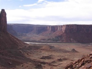
We were in the middle of our third day on White Rim when we finished it at the intersection with Mineral Bottom. We turned left to check out the end of the trail, and we hoped to make some progress into both Hell Roaring Canyon and Mineral Canyon. The road at this intersection is easy and well maintained.

We didn't drive far before we had the Green River in our sights, and then we were at the boat ramp. It was hot, and we spotted shade under big cottonwood trees near the water's edge. We parked in the lot and walked over to set up lunch under the trees.

It was a fantastic lunch, of course. We were in desert shade, our favorite kind. The water was nearby but the bugs behaved themselves for the most part. We snacked on a light lunch and enjoyed each other's company for a while before packing up.

We got to the intersection of the end trails and decided to explore Hell Roaring Canyon first. It was right along the water, and as we got farther in the trail got more narrow and less well used. We came to a secluded and cozy camp spot along the river, and the trail got much more narrow past it. The campsite allowed us to make a small loop to turn around, and we headed back.

We checked out the landing strip on the way back to the intersection. It wasn't big or fancy, but it would be a quick and relatively easy way to get to the water here.

We went into Mineral Canyon next and it was much wider. We could see evidence of old roads leading up the sides to old mining areas on both sides of the canyon. The trail was fairly easy until suddenly it wasn't. We weren't up for getting stuck on a narrow trail so we turned around about halfway to the end and headed back.

The Mineral Bottom Switchbacks are awesome! They're steep and smooth like the Shafer Switchbacks, though they are usually wide enough for someone else to pass. It was fun and very scenic to climb out of the canyon to the parking area at the top.

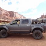
After that fun the trail was very straight and very smooth all the way out. It was a long drive but it was scenic. When we got to the end we aired up before heading into Moab. We'd been camping in the hot desert for two nights and we all looked forward to a shower and a bed. We had dinner but no one stayed out very late. We were the best kind of exhausted.

ben_in_mineral_canyon
ben_on_the_trail
big_sky
bighorn_sheep_sign
boat_ramp_kiosk_part_1
boat_ramp_kiosk_part_2
boat_ramp_kiosk_part_3
boat_ramp_kiosk_part_4
boat_ramp_sign
boat_ramp
brush
buttes
close_to_the_river
curve
getting_narrow
graded
green_river_overlook
headlight_cairn
landing_strip_sign
les_in_scenery
matt_in_scenery
matt_up_the_switchbacks
mellow_mineral_canyon
mineral_canyon
near_white_rim
out_of_a_wash
parking_area_sign
pipe_cloud
pit_toilets
reds_and_greens
straight_and_easy
to_hell_roaring_canyon
to_the_water
trail_with_a_view
up_the_switchbacks_part_1
up_the_switchbacks_part_2
up_the_switchbacks_part_3
up_the_switchbacks_part_4
up_the_switchbacks_part_5
up_the_switchbacks_part_6
up_the_switchbacks_part_7
walt_on_the_trail

Report from a Different Day

March 29, 2006

Led by Ladd G.
We hit Mineral Bottom after running White Rim, and it was our trail back to Moab. It had rained earlier in the day and we read that the switchbacks can be dangerous if wet. It looked like the trail was dry enough so we started climbing the switchbacks. The trail…
Join Us!
If you aren’t a Member or Subscriber, you can’t see all of the content on this site. Get membership information to see why this site is best when you join and log in

Information for Subscribers

When you log in you’ll see more information here:

  • Recent Community Forum posts
  • Recent polls
  • Upcoming Events you can attend
  • Links to online users

© 2000-2022 · TrailDamage.com · Terms and Conditions · About · Contact
Trail information is only accurate on the date posted. Trails may have changed or closed since that date. Use this information for historical purposes only.
Contact the Forest Service or Bureau of Land Management for up-to-date trail information.

/* ----------------------------------------- */ /* View slug: reports-other-reports-for-same-trail-slider - start */ /* ----------------------------------------- */ /* place the prev/next controls on the sides */ .td-transition-controls .wpv-filter-next-link, .td-transition-controls .wpv-filter-previous-link { border: none; font-size: 300%; position: absolute; top: 70px; } .td-transition-controls .wpv-filter-previous-link { left: 0; } .td-transition-controls .wpv-filter-next-link { right: 0; } /* center the page selector horizonatally */ .td-transition-controls ul.wpv_pagination_dots { text-align: center; margin-top: 10px; } /* center the page selector horizonatally */ .td-transition-controls ul.wpv_pagination_dots li.wpv_pagination_dots_item, .td-transition-controls .wpv_pagination_dots li a { display: inline-block; float: none; } /* remove the default styles */ .td-transition-controls .wpv_pagination_dots li a { text-decoration: none; border-bottom: none; } .td-slider-container { padding: 0 25px; margin-bottom: 20px; position: relative; width:100%; display:table; } .td-slides { position: relative; } .td-slides-image { float:left; display:table-cell; } .td-slides-image img { border:1px solid #c0c0c0; } .td-slides-content { padding:4px 4px 4px 10px; border-top:1px solid #c0c0c0; border-right:1px solid #c0c0c0; border-bottom:1px solid #c0c0c0; display:table-cell; height:227px; overflow:hidden; } .td-slides-content h3 { margin-top:8px; } .td-slides-leader { font-size:smaller; margin-top:4px; } /* ----------------------------------------- */ /* View slug: reports-other-reports-for-same-trail-slider - end */ /* ----------------------------------------- */
/* ----------------------------------------- */ /* Content Template: Template for a Single Report - start */ /* ----------------------------------------- */ .entry-header { display:none; } .entry-content h1 { margin-top:16px; padding-top:0; } h1 a { color:#222; } h1 a:hover { color:#666; } p.entry-meta { font-size:small; } #report-body-spacer { clear:both; width:100%; height:20px; } #addtoany-bar { margin-bottom:2em; text-align:center; } .category-reports .post-info .author, .post-info .date { display: none; } .addthis_recommended_horizontal { text-align:center !important; } /* ----------------------------------------- */ /* Content Template: Template for a Single Report - end */ /* ----------------------------------------- */ /* ----------------------------------------- */ /* Content Template: Loop item in REPORTS Runners - start */ /* ----------------------------------------- */ #runners-container { width:100%; clear:both; } .runner { border:1px solid #c0c0c0; margin:0 6px 6px 0; float:left; width:49%; height:81px; } .runner-image { float: left; } .runner-image img { margin:2px 10px 0 2px; height:75px; width:75px; } .runner-name { text-transform:uppercase; } .runner-name a { color:#222; } .runner-name a:hover { color:#666; } .runner-vehicle { font-size:small; } @media only screen and (max-width: 768px) { .runner { width:100%; } } /* ----------------------------------------- */ /* Content Template: Loop item in REPORTS Runners - end */ /* ----------------------------------------- */