TrailDamage.com

Photos, videos and information about 4x4 trails in Colorado and Utah

  • Trails
    • Colorado
    • Utah
  • Reports
    • Featured Photos
    • Featured Videos
    • Reports Calendar
  • Members
  • Search
  • Trail Damage Winners
  • FAQ
  • Community
  • Upcoming Events
  • Membership
  • Log In
  • Facebook
  • Instagram
  • RSS
  • Twitter
  • YouTube

Metberry Gulch 091025

October 25, 2009 by Matt Kuczborski

Metberry Gulch

Trail Run on October 25, 2009
Report and photos by Matt K., Trail Leader
View trail information for Metberry Gulch

Walt S.
Gray 2018 Jeep Wrangler Unlimited Rubicon
Matt K.
White 2016 Jeep Wrangler Unlimited Rubicon
Mike S.
Silver 2004 Jeep Wrangler Rubicon
Roger R.
White 2005 Jeep Wrangler Unlimited Rubicon

Sunday was the second day of our marathon weekend of wheeling. We had run seven trails on Saturday, all in the Rampart Range area. The trails the day before were covered in snow, and we were expecting fresh snow during the day on Sunday. That fact coupled with the fact that Sunday's trails were more difficult made us unsure of what to expect.

We met at the general store in Deckers at 10:00AM and aired down there. Since there was just four of us, we were on the road soon after the meeting time. With the threat of snow we wasted no time getting to the trailhead off of Cedar Mountain Road.

The first part of the trail presented no real challenges. The snow already on the trail added a little difficulty but generally not enough to dictate use of 4-wheel drive. The climbs, descents and rocky sections were all handled easily. Matt got some good flex on the rocks, taking the most difficult line through.

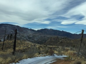
Further down the trail we were close to the layer of the clouds above us and the trees were covered in a light layer of ice. We were in part of the area devastated by the Hayman Fire in 2002. The stark contrast between the fire-blackened tree trunks and the sparkling ice was dramatic. It didn't help that the lowering clouds meant this same ice could affect the trail as well. This fear turned out to be unfounded, however, as the steepest slopes of the trail were all south-facing and relatively clear of snow.

We all made it down the Rock Slab without incident and were pleased to see it free of snow as well, although the wet sand could cause some traction problems on the way up. After the steep descents, we were soon down to the river and our lunch spot. It was cold and it was starting to snow, so we ate standing up and didn't linger.

The climb back out to the trailhead was uneventful, with Roger even taking the steepest hills in 2-wheel drive. The rest of us opted for the gearing provided by 4-low, though traction never seemed to be an issue, even on the Rock Slab.

We soon were back at the trailhead ready for the challenge of Longwater Gulch and Hackett Gulch, trails new to most of us as they had been closed since the Hayman Fire.

airing_down
first_repaired_section
ice_in_the_trees
jeeps_down_the_hill_part_1
jeeps_down_the_hill_part_2
jeeps_down_the_hill_part_3
jeeps_on_the_trail
lunch_at_the_river
matt_down_the_rock_slab_part_1
matt_down_the_rock_slab_part_2
matt_down_the_rock_slab_part_3
matt_on_the_rocks_part_1
matt_on_the_rocks_part_2
matt_on_the_rocks_part_3
matt_through_the_trees
on_the_way_to_the_trailhead
roger_down_the_rock_slab_part_1
roger_down_the_rock_slab_part_2
roger_down_the_rock_slab_part_3
roger_on_cedar_mountain_road
roger_on_the_rocks_part_1
roger_on_the_rocks_part_2
second_repaired_section
south_platte_river_part_1
south_platte_river_part_2
start_of_the_trail
walt_down_the_rock_slab_part_1
walt_down_the_rock_slab_part_2
walt_down_the_rock_slab_part_3
walt_on_cedar_mountain_road
walt_on_the_rocks_part_1
walt_on_the_rocks_part_2
walt_on_the_rocks_part_3
walt_through_the_trees

Reports from Other Days: 4

Use the arrows or dots to flip through the previews of the other reports for Metberry Gulch. Click one of them to read more and see all of the photos from that day.

May 23, 2010

Led by Matt K.
This was the last trail of the day off of Cedar Mountain Road. At the gate for Metberry Gulch there was a sign warning about a big mud hole. We drove down the trail for some time and eventually came to the big mud hole that the sign warned us…
« »
  • 1
  • 2
  • 3
  • 4
Join Us!
If you aren’t a Member or Subscriber, you can’t see all of the content on this site. Get membership information to see why this site is best when you join and log in

Information for Subscribers

When you log in you’ll see more information here:

  • Recent Community Forum posts
  • Recent polls
  • Upcoming Events you can attend
  • Links to online users

© 2000-2021 · TrailDamage.com · Terms and Conditions · About · Contact
Trail information is only accurate on the date posted. Trails may have changed or closed since that date. Use this information for historical purposes only.
Contact the Forest Service or Bureau of Land Management for up-to-date trail information.

/* ----------------------------------------- */ /* View slug: reports-other-reports-for-same-trail-slider - start */ /* ----------------------------------------- */ /* place the prev/next controls on the sides */ .td-transition-controls .wpv-filter-next-link, .td-transition-controls .wpv-filter-previous-link { border: none; font-size: 300%; position: absolute; top: 70px; } .td-transition-controls .wpv-filter-previous-link { left: 0; } .td-transition-controls .wpv-filter-next-link { right: 0; } /* center the page selector horizonatally */ .td-transition-controls ul.wpv_pagination_dots { text-align: center; margin-top: 10px; } /* center the page selector horizonatally */ .td-transition-controls ul.wpv_pagination_dots li.wpv_pagination_dots_item, .td-transition-controls .wpv_pagination_dots li a { display: inline-block; float: none; } /* remove the default styles */ .td-transition-controls .wpv_pagination_dots li a { text-decoration: none; border-bottom: none; } .td-slider-container { padding: 0 25px; margin-bottom: 20px; position: relative; width:100%; display:table; } .td-slides { position: relative; } .td-slides-image { float:left; display:table-cell; } .td-slides-image img { border:1px solid #c0c0c0; } .td-slides-content { padding:4px 4px 4px 10px; border-top:1px solid #c0c0c0; border-right:1px solid #c0c0c0; border-bottom:1px solid #c0c0c0; display:table-cell; height:227px; overflow:hidden; } .td-slides-content h3 { margin-top:8px; } .td-slides-leader { font-size:smaller; margin-top:4px; } /* ----------------------------------------- */ /* View slug: reports-other-reports-for-same-trail-slider - end */ /* ----------------------------------------- */
/* ----------------------------------------- */ /* Content Template: Template for a Single Report - start */ /* ----------------------------------------- */ .entry-header { display:none; } .entry-content h1 { margin-top:16px; padding-top:0; } h1 a { color:#222; } h1 a:hover { color:#666; } p.entry-meta { font-size:small; } #report-body-spacer { clear:both; width:100%; height:20px; } #addtoany-bar { margin-bottom:2em; text-align:center; } .category-reports .post-info .author, .post-info .date { display: none; } .addthis_recommended_horizontal { text-align:center !important; } /* ----------------------------------------- */ /* Content Template: Template for a Single Report - end */ /* ----------------------------------------- */ /* ----------------------------------------- */ /* Content Template: Loop item in REPORTS Runners - start */ /* ----------------------------------------- */ #runners-container { width:100%; clear:both; } .runner { border:1px solid #c0c0c0; margin:0 6px 6px 0; float:left; width:49%; height:81px; } .runner-image { float: left; } .runner-image img { margin:2px 10px 0 2px; height:75px; width:75px; } .runner-name { text-transform:uppercase; } .runner-name a { color:#222; } .runner-name a:hover { color:#666; } .runner-vehicle { font-size:small; } @media only screen and (max-width: 768px) { .runner { width:100%; } } /* ----------------------------------------- */ /* Content Template: Loop item in REPORTS Runners - end */ /* ----------------------------------------- */