TrailDamage.com

Photos, videos and information about 4x4 trails in Colorado and Utah

  • Trails
    • Colorado
    • Utah
  • Reports
    • Featured Photos
    • Featured Videos
    • Reports Calendar
  • Members
  • Search
  • Trail Damage Winners
  • FAQ
  • Community
  • Upcoming Events
  • Membership
  • Log In
  • Facebook
  • Instagram
  • RSS
  • Twitter
  • YouTube

Metal Masher 051006

October 6, 2005 by Monica

Metal Masher

Trail Run on October 6, 2005
Report and photos by Monica I., Trail Leader
View trail information for Metal Masher

Mike S.
Silver 2004 Jeep Wrangler Rubicon
Ladd G.
Green 2003 Jeep Wrangler Rubicon
Monica I.
Red 2010 Jeep Wrangler Rubicon
Cheryl W.
Orange 2006 Jeep Wrangler Unlimited Rubicon
Bob S.
Green 1997 Jeep Wrangler
Eric B.
Green 2000 Jeep Wrangler

We were at the Metal Masher trailhead sign at 5PM when we decided that we still wanted to do the trail. Bob was on a mission to conquer Widowmaker, and no one was ready to quit wheeling for the day.

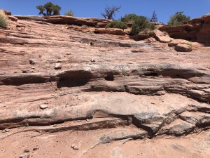
The trail was marked by painted white lizards this time, making it even easier to find. This has never really been a difficult trail to find, though.

It was pretty mellow until we got to the place where Wayne bent back his tailpipe last year. Monica tried it and failed miserably again, so she backed back down. Bob got in it and spun some tires, but it wasn't happening for him either. We all just kept going, so no one made it up that hill again.

We didn't see any other vehicles on the trail, and we got to Rock Chucker in about an hour from when we were at the trailhead. Bob was excited to do it again, so he got right on it. He popped right over the top with no issues at all.

Monica decided to try it next, and everyone decided that if she made it they'd all have to try it. She made it right up, so then it was everyone's turn.

While Bob was spotting Monica up the obstacle he did some crazy hand movements that were caught on video. This "dance" is now called "The Bob" and one we did regularly during the following day on Pritchett Canyon as well as on the trip home to Denver in a blizzard.

Eric went up Rock Chucker next, like he was on a paved road. It went so fast that some people even missed seeing it.

Mike and Cheryl went up next and didn't have any troubles with their silver Rubicons. Ladd brought up the rear and did a bunch of sliding around at the top, but he kept on it and popped right up. We all did Rock Chucker and we were feeling pretty good!

The little bit of trail that takes you from the top of Rock Chucker back down to the main trail is more challenging than you would think. There are a few cool sections, then you have a very steep downhill part followed by another downhill section that is tippy. It was even fun coming down from that, so we had a blast getting back to the trail.

The sun was starting to set as we got to Mirror Gulch. There were a few tires spinning on the way into the obstacle, but otherwise everyone just drove right through it. It's a fun section.

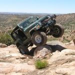
The fun hill came next, and everyone took the optional way through it at the top, where it is steep. When we ran this trail last time we all went around it, and that proved to be an interesting section when Ladd and Eric both got a pretty crazy wheelstand. This time it was just a challenging obstacle and no one got into any weird positions.

We got to the cliff edge as the light was finally leaving us, and the highway looked really cool with all of the headlights from the cars below. It was a gorgeous sunset.

Naturally we decided to go try Widowmaker in the dark. Monica went up first and forgot about the left turn as you got to the pole at the top of the hill before the obstacle, dropping her front tire off the edge. She backed out of it, but it was close.

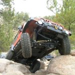
After we all got to the top, Bob was ready to try Widowmaker. We found a wimpy winch point in the rocks, so he got his Jeep ready to winch, just in case.

Bob got up on it and started giving it some gas, spinning tires and making some progress. Then he slid off to the right like so many have, but he kept on it. Finally, his front tires started sliding off to the left, putting him a little sideways on the hill so he stopped. He ended up on the rock on the right, unable to back down.

Bob's plan was to winch himself high enough to get off the rock, then back down to try again. It was working just fine until the flimsy winch point broke and Bob came back down on the rock. He couldn't go forward and he couldn't go back, so he was stuck.

Mike and Monica started down the hill to take the bypass and get over to the top of Widowmaker so Bob could winch off of their Jeeps. Even though they hurried and only lost about two minutes lost on some slickrock, it still took about 30 minutes to come around. Bob was stuck in his seatbelt the entire time, and was ready to get off the obstacle by the time they got there.

While they were waiting, Cheryl was playing with Cole and moving some rocks around, hurting her back in the process. Everyone helped her crawl up Widowmaker and get in her Jeep, and Don drove the rest of the trail. No one wanted to be winched up Widowmaker after Bob, so everyone else went around to the bypass.

Eventually we all caught up and were all together again at the top of Widowmaker. We slowly worked our way to the end of the trail, then decided to go out to Highway 313 instead of back by Gooney Bird Rock. It ended up being a nice, smooth ride to the highway, which was good for Cheryl.

It was far back to town and the next day's trail was far south of town so we aired up before going back to Moab. It was a chilly ride but we finally got home to dinner in the condo. It was a great day, even though no one made it up Widowmaker. Next time!

bob_on_rock_chucker_part_1
bob_on_rock_chucker_part_2
bob_on_rock_chucker_part_3
bob_on_rock_chucker_part_4
bob_on_rock_chucker_part_5
bob_on_tailpipe_hill
bob_playing
bob_up_the_fun_hill
cheryl_and_cole
cheryl_and_rocks
cheryl_down_a_steep_part_part_1
cheryl_down_a_steep_part_part_2
cheryl_down_a_steep_part_part_3
cheryl_mandatory_picture
cheryl_on_rock_chucker_part_1
cheryl_on_rock_chucker_part_2
cheryl_on_rock_chucker_part_3
cheryl_on_rock_chucker_part_4
cheryl_on_rock_chucker_part_5
cheryl_over_a_crack
cheryl_playing
cheryl_up_the_fun_hill
dusk
early_trail
eric_down_a_steep_part_part_1
eric_down_a_steep_part_part_2
eric_on_rock_chucker
eric_up_the_fun_hill
fun_hill
going_by_gooney_bird_rock
highway
ladd_down_a_steep_part
ladd_on_rock_chucker_part_1
ladd_on_rock_chucker_part_2
ladd_on_rock_chucker_part_3
ladd_on_rock_chucker_part_4
ladd_on_rock_chucker_part_5
ladd_on_rock_chucker_part_6
ladd_playing
ladd_up_the_fun_hill
lizard_marker
mike_down_a_steep_part
mike_on_rock_chucker_part_1
mike_on_rock_chucker_part_2
mike_on_rock_chucker_part_3
mike_on_rock_chucker_part_4
mike_on_rock_chucker_part_5
mike_playing
mike_up_the_fun_hill
moab_part_1
moab_part_2
monica_on_rock_chucker_part_1
monica_on_rock_chucker_part_2
monica_on_rock_chucker_part_3
moon
rock_chucker
sunset_part_1
sunset_part_2
trailhead_sign
yay

Reports from Other Days: 4

Use the arrows or dots to flip through the previews of the other reports for Metal Masher. Click one of them to read more and see all of the photos from that day.

May 24, 2020

Led by Matt K.
The weather forecast for the day was great and we met and aired down at the parking area just off the main Highway 191. The sun was out and we were warm but not too hot. The start of Metal Masher was easy going with some sand. The first ledges…
»
  • 1
  • 2
  • 3
  • 4
Join Us!
If you aren’t a Member or Subscriber, you can’t see all of the content on this site. Get membership information to see why this site is best when you join and log in

Information for Subscribers

When you log in you’ll see more information here:

  • Recent Community Forum posts
  • Recent polls
  • Upcoming Events you can attend
  • Links to online users

© 2000-2023 · TrailDamage.com · Terms and Conditions · About · Contact
Trail information is only accurate on the date posted. Trails may have changed or closed since that date. Use this information for historical purposes only.
Contact the Forest Service or Bureau of Land Management for up-to-date trail information.

/* ----------------------------------------- */ /* View slug: reports-other-reports-for-same-trail-slider - start */ /* ----------------------------------------- */ /* place the prev/next controls on the sides */ .td-transition-controls .wpv-filter-next-link, .td-transition-controls .wpv-filter-previous-link { border: none; font-size: 300%; position: absolute; top: 70px; } .td-transition-controls .wpv-filter-previous-link { left: 0; } .td-transition-controls .wpv-filter-next-link { right: 0; } /* center the page selector horizonatally */ .td-transition-controls ul.wpv_pagination_dots { text-align: center; margin-top: 10px; } /* center the page selector horizonatally */ .td-transition-controls ul.wpv_pagination_dots li.wpv_pagination_dots_item, .td-transition-controls .wpv_pagination_dots li a { display: inline-block; float: none; } /* remove the default styles */ .td-transition-controls .wpv_pagination_dots li a { text-decoration: none; border-bottom: none; } .td-slider-container { padding: 0 25px; margin-bottom: 20px; position: relative; width:100%; display:table; } .td-slides { position: relative; } .td-slides-image { float:left; display:table-cell; } .td-slides-image img { border:1px solid #c0c0c0; } .td-slides-content { padding:4px 4px 4px 10px; border-top:1px solid #c0c0c0; border-right:1px solid #c0c0c0; border-bottom:1px solid #c0c0c0; display:table-cell; height:227px; overflow:hidden; } .td-slides-content h3 { margin-top:8px; } .td-slides-leader { font-size:smaller; margin-top:4px; } /* ----------------------------------------- */ /* View slug: reports-other-reports-for-same-trail-slider - end */ /* ----------------------------------------- */
/* ----------------------------------------- */ /* Content Template: Template for a Single Report - start */ /* ----------------------------------------- */ .entry-header { display:none; } .entry-content h1 { margin-top:16px; padding-top:0; } h1 a { color:#222; } h1 a:hover { color:#666; } p.entry-meta { font-size:small; } #report-body-spacer { clear:both; width:100%; height:20px; } #addtoany-bar { margin-bottom:2em; text-align:center; } .category-reports .post-info .author, .post-info .date { display: none; } .addthis_recommended_horizontal { text-align:center !important; } /* ----------------------------------------- */ /* Content Template: Template for a Single Report - end */ /* ----------------------------------------- */ /* ----------------------------------------- */ /* Content Template: Loop item in REPORTS Runners - start */ /* ----------------------------------------- */ #runners-container { width:100%; clear:both; } .runner { border:1px solid #c0c0c0; margin:0 6px 6px 0; float:left; width:49%; height:81px; } .runner-image { float: left; } .runner-image img { margin:2px 10px 0 2px; height:75px; width:75px; } .runner-name { text-transform:uppercase; } .runner-name a { color:#222; } .runner-name a:hover { color:#666; } .runner-vehicle { font-size:small; } @media only screen and (max-width: 768px) { .runner { width:100%; } } /* ----------------------------------------- */ /* Content Template: Loop item in REPORTS Runners - end */ /* ----------------------------------------- */