TrailDamage.com

Photos, videos and information about 4x4 trails in Colorado and Utah

  • Trails
    • Colorado
    • Utah
  • Reports
    • Featured Photos
    • Featured Videos
    • Reports Calendar
  • Members
  • Search
  • Trail Damage Winners
  • FAQ
  • Community
  • Upcoming Events
  • Membership
  • Log In
  • Facebook
  • Instagram
  • RSS
  • Twitter
  • YouTube

Longwater Gulch 091025

October 25, 2009 by Matt Kuczborski

Longwater Gulch

Trail Run on October 25, 2009
Report and photos by Matt K., Trail Leader
View trail information for Longwater Gulch

Matt K.
White 2016 Jeep Wrangler Unlimited Rubicon
Walt S.
Gray 2022 Jeep Wrangler Unlimited Rubicon 392
Mike S.
Silver 2004 Jeep Wrangler Rubicon
Roger R.
Gray 2021 Jeep Wrangler Rubicon 4xe

Our second trail of the day was Longwater Gulch. Walt had been down this trail before the 2002 Hayman Fire devastated the area, but because the trail had only recently been partially reopened this year, it was a new trail for most of us. We weren't sure quite what to expect. It was generally thought that this trail would be a lot like Metberry Gulch and that proved to be the case.

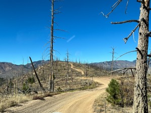
Longwater Gulch is remarkably like Metberry Gulch, right down to the trail profile, the transition from live forest to the burned area, the relative location of the Rock Slab obstacle and the steep descents and ascents. The big difference, of course, is that the trail does not currently extend to the South Platte River like Metberry Gulch does. Instead, it ends at the Park County line.

The first issue we faced was two blow-downs completely blocking the trail. They were too big to go over and we weren't ready to turn around and call it quits. Mike hooked up a snatch block and winched the first tree to the side. The second blow-down was also easily winched out of the way and we were soon heading down the rest of the trail.

We all had a semi-controlled slide down the Rock Slab as there wasn't enough traction to hold our Jeeps on the slope. We knew this could be difficult to get back up, but we were already committed. We continued down the rest of the steep slopes and were soon at the end of the trail. Even though we knew ahead of time that the trail was closed at the county line, we were still disappointed when we saw the signs and gate. Perhaps Park County will someday open the rest of the trail.

We turned around and headed back up, soon reaching the Rock Slab. Mike was first and tentatively approached the right-hand side of the slab. With all four tires on the sandy, muddy slab, he just spun all of them. Lockers weren't even enough to crawl up this obstacle. However, when he backed up and then hit the obstacle in second gear he had enough momentum to pop right up to the top. Breathing a sigh of relief, he parked and went back for photos of Matt making the climb.

Matt had no trouble, trying the right-hand line, until he hit the stump on the right with his passenger-side front tire. The Jeep simply climbed up the stump, getting two feet of air under the driver-side front tire. Awesome! However, when he came back down off the stump, the Jeep was sitting at an angle on the steep slope. Any attempt to go forward was met with the front sliding further down the slope. Any attempt to go back placed his Jeep in an even more precarious position. Matt assessed his position and opted to take a strap from Mike and he drove up the slope with the strap providing support to keep him from sliding.

After Matt, Walt tried a line up the center of the slab, but this was off-camber and steep so he backed down and tried the right-most line. He missed the stump with the help of some spotting and was quickly up the rock after hitting it with some momentum. Roger quickly followed with no theatrics.

After the Rock Slab, the trip back to the trailhead was uneventful. We were soon back on Cedar Mountain Road and headed for Hackett Gulch. Matt left us at that point, however, as it was getting late and he had his father-in-law from Germany with him.

clearing_a_blowdown_part_1
clearing_a_blowdown_part_2
clearing_a_blowdown_part_3
clearing_a_blowdown_part_4
early_trail
little_half_dome
matt_down_the_rock_slab_part_1
matt_down_the_rock_slab_part_2
matt_down_the_rock_slab_part_3
matt_down_the_rock_slab_part_4
matt_on_the_trail
matt_up_the_rock_slab_part_1
matt_up_the_rock_slab_part_2
matt_up_the_rock_slab_part_3
mike_up_the_rock_slab_part_1
mike_up_the_rock_slab_part_2
mike_up_the_rock_slab_part_3
roger_down_the_rock_slab_part_1
roger_down_the_rock_slab_part_2
roger_down_the_rock_slab_part_3
roger_up_the_rock_slab_part_1
roger_up_the_rock_slab_part_2
roger_up_the_rock_slab_part_3
snowy_trail
trail_closed_signs_part_1
trail_closed_signs_part_2
trail_closed_signs_part_3
trail_closed_signs_part_4
trail_through_the_dead_trees_part_1
trail_through_the_dead_trees_part_2
walt_down_the_rock_slab_part_1
walt_down_the_rock_slab_part_2
walt_down_the_rock_slab_part_3
walt_on_the_trail
walt_up_the_rock_slab_part_1
walt_up_the_rock_slab_part_2
walt_up_the_rock_slab_part_3
walt_up_the_rock_slab_part_4
walt_up_the_rock_slab_part_5

Reports from Other Days: 4

Use the arrows or dots to flip through the previews of the other reports for Longwater Gulch. Click one of them to read more and see all of the photos from that day.

October 16, 2021

Led by Matt K.
Longwater Gulch was the second trail for the day after Hackett Gulch. We did see a lot more wet Jeeps and side-by-sides going up Longwater Gulch as we made our way down Longwater Gulch. It was fun going up and down the hill on Longwater. At times near the top…
»
  • 1
  • 2
  • 3
  • 4
Join Us!
If you aren’t a Member or Subscriber, you can’t see all of the content on this site. Get membership information to see why this site is best when you join and log in

Information for Subscribers

When you log in you’ll see more information here:

  • Recent Community Forum posts
  • Recent polls
  • Upcoming Events you can attend
  • Links to online users

© 2000-2023 · TrailDamage.com · Terms and Conditions · About · Contact
Trail information is only accurate on the date posted. Trails may have changed or closed since that date. Use this information for historical purposes only.
Contact the Forest Service or Bureau of Land Management for up-to-date trail information.

/* ----------------------------------------- */ /* View slug: reports-other-reports-for-same-trail-slider - start */ /* ----------------------------------------- */ /* place the prev/next controls on the sides */ .td-transition-controls .wpv-filter-next-link, .td-transition-controls .wpv-filter-previous-link { border: none; font-size: 300%; position: absolute; top: 70px; } .td-transition-controls .wpv-filter-previous-link { left: 0; } .td-transition-controls .wpv-filter-next-link { right: 0; } /* center the page selector horizonatally */ .td-transition-controls ul.wpv_pagination_dots { text-align: center; margin-top: 10px; } /* center the page selector horizonatally */ .td-transition-controls ul.wpv_pagination_dots li.wpv_pagination_dots_item, .td-transition-controls .wpv_pagination_dots li a { display: inline-block; float: none; } /* remove the default styles */ .td-transition-controls .wpv_pagination_dots li a { text-decoration: none; border-bottom: none; } .td-slider-container { padding: 0 25px; margin-bottom: 20px; position: relative; width:100%; display:table; } .td-slides { position: relative; } .td-slides-image { float:left; display:table-cell; } .td-slides-image img { border:1px solid #c0c0c0; } .td-slides-content { padding:4px 4px 4px 10px; border-top:1px solid #c0c0c0; border-right:1px solid #c0c0c0; border-bottom:1px solid #c0c0c0; display:table-cell; height:227px; overflow:hidden; } .td-slides-content h3 { margin-top:8px; } .td-slides-leader { font-size:smaller; margin-top:4px; } /* ----------------------------------------- */ /* View slug: reports-other-reports-for-same-trail-slider - end */ /* ----------------------------------------- */
/* ----------------------------------------- */ /* Content Template: Template for a Single Report - start */ /* ----------------------------------------- */ .entry-header { display:none; } .entry-content h1 { margin-top:16px; padding-top:0; } h1 a { color:#222; } h1 a:hover { color:#666; } p.entry-meta { font-size:small; } #report-body-spacer { clear:both; width:100%; height:20px; } #addtoany-bar { margin-bottom:2em; text-align:center; } .category-reports .post-info .author, .post-info .date { display: none; } .addthis_recommended_horizontal { text-align:center !important; } /* ----------------------------------------- */ /* Content Template: Template for a Single Report - end */ /* ----------------------------------------- */ /* ----------------------------------------- */ /* Content Template: Loop item in REPORTS Runners - start */ /* ----------------------------------------- */ #runners-container { width:100%; clear:both; } .runner { border:1px solid #c0c0c0; margin:0 6px 6px 0; float:left; width:49%; height:81px; } .runner-image { float: left; } .runner-image img { margin:2px 10px 0 2px; height:75px; width:75px; } .runner-name { text-transform:uppercase; } .runner-name a { color:#222; } .runner-name a:hover { color:#666; } .runner-vehicle { font-size:small; } @media only screen and (max-width: 768px) { .runner { width:100%; } } /* ----------------------------------------- */ /* Content Template: Loop item in REPORTS Runners - end */ /* ----------------------------------------- */