TrailDamage.com

Photos, videos and information about 4x4 trails in Colorado and Utah

  • Trails
    • Colorado
    • Utah
  • Reports
    • Featured Photos
    • Featured Videos
    • Reports Calendar
  • Members
  • Search
  • Trail Damage Winners
  • FAQ
  • Community
  • Upcoming Events
  • Membership
  • Log In
  • Facebook
  • Instagram
  • RSS
  • Twitter
  • YouTube

Lime Creek 100911

September 11, 2010 by Monica

Lime Creek

Trail Run on September 11, 2010
Report and photos by Monica I., Trail Leader
View trail information for Lime Creek

Matt K.
White 2016 Jeep Wrangler Unlimited Rubicon
Dave E.
Blue 1999 Jeep Cherokee
Austin C.
Khaki 2004 Jeep Wrangler Unlimited Rubicon
Randy J.
Purple 1999 Jeep Cherokee
Monica I.
Red 2010 Jeep Wrangler Rubicon

Even though we had already done a lot of trail miles and it was late in the afternoon, most of our group decided we could still fit Lime Creek in before we headed for home. It's a favorite trail for the group, and we didn't want to miss it.

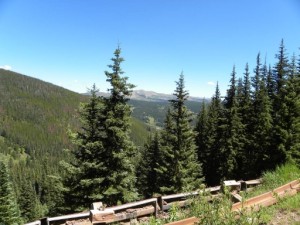
We saw a guy on a dirt bike at the trailhead, but then we didn't see anyone else until we were nearly at the end of the trail. That made for a relaxing time watching the shadows get longer as we watched the gorgeous scenery go by.

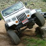
The first section of the trail is a fun climb, and everyone enjoyed it. The main obstacle was dry and not too difficult. We had already played in the rocks on Ptarmigan Pass, so this section of rocks wasn't too difficult, but it was still really fun.

We climbed for a bit until we came to the flat section, driving through meadows and patches of trees. The trail was fairly mellow, and everyone was on the CB talking about how gorgeous everyone was. You could see the greens starting to turn to fall colors, and it was very scenic.

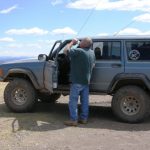
We pulled over at the first wide spot, though that was quite a way into the trail. We hung out for quite awhile, enjoying the perfect weather and everyone's company. Dave and Randy were visiting from Minnesota and we all talked about the former Jeeps we had owned. It was a really nice spot and we had it all to ourselves.

Reluctantly, we got back in our Jeeps and continued on. We were at the muddy spot just before the last hill climb when Dave needed to stop because of a rear leaf spring hitting something. He had done some work on his springs before leaving Minnesota, and they were giving him issues. He got it all fixed, though, and we were soon on our way again.

The last hill climb was a fun and rocky one, with many lines on the way up. Everyone enjoyed it, and it ended too soon. At the top, we found ourselves on the easy road.

The rest of the trail was mellow and we stayed far from each other to keep out of the dust. When we got back to Shrine Pass, we headed back to I-70. It was a fantastic day!

aspens
break_time_part_1
break_time_part_2
bridge
bumpy
climbing
creek_crossing
curve
dave_trail_fix
easier_trail
embedded_rocks
green
last_bumpy_climb
matt_on_the_trail
meadow
obstacle_ahead
on_the_way_out
rocks_in_trees
rocky_start
rough_trail
scenic
shade
sign_at_the_end
slanted
steep_drop_off
trail_ahead
trailhead
wet_trail

Reports from Other Days: 2

Use the arrows or dots to flip through the previews of the other reports for Lime Creek. Click one of them to read more and see all of the photos from that day.

August 1, 2009

Led by Dave B.
After running about half of Shrine Pass we reached the Lime Creek trailhead. For the first time of the day everyone put their Jeeps in 4-Low. The beginning of the trail is a rocky, uphill climb. Before long we came to the first obstacle, a large rock in the middle…
»
  • 1
  • 2
Join Us!
If you aren’t a Member or Subscriber, you can’t see all of the content on this site. Get membership information to see why this site is best when you join and log in

Information for Subscribers

When you log in you’ll see more information here:

  • Recent Community Forum posts
  • Recent polls
  • Upcoming Events you can attend
  • Links to online users

© 2000-2022 · TrailDamage.com · Terms and Conditions · About · Contact
Trail information is only accurate on the date posted. Trails may have changed or closed since that date. Use this information for historical purposes only.
Contact the Forest Service or Bureau of Land Management for up-to-date trail information.

/* ----------------------------------------- */ /* View slug: reports-other-reports-for-same-trail-slider - start */ /* ----------------------------------------- */ /* place the prev/next controls on the sides */ .td-transition-controls .wpv-filter-next-link, .td-transition-controls .wpv-filter-previous-link { border: none; font-size: 300%; position: absolute; top: 70px; } .td-transition-controls .wpv-filter-previous-link { left: 0; } .td-transition-controls .wpv-filter-next-link { right: 0; } /* center the page selector horizonatally */ .td-transition-controls ul.wpv_pagination_dots { text-align: center; margin-top: 10px; } /* center the page selector horizonatally */ .td-transition-controls ul.wpv_pagination_dots li.wpv_pagination_dots_item, .td-transition-controls .wpv_pagination_dots li a { display: inline-block; float: none; } /* remove the default styles */ .td-transition-controls .wpv_pagination_dots li a { text-decoration: none; border-bottom: none; } .td-slider-container { padding: 0 25px; margin-bottom: 20px; position: relative; width:100%; display:table; } .td-slides { position: relative; } .td-slides-image { float:left; display:table-cell; } .td-slides-image img { border:1px solid #c0c0c0; } .td-slides-content { padding:4px 4px 4px 10px; border-top:1px solid #c0c0c0; border-right:1px solid #c0c0c0; border-bottom:1px solid #c0c0c0; display:table-cell; height:227px; overflow:hidden; } .td-slides-content h3 { margin-top:8px; } .td-slides-leader { font-size:smaller; margin-top:4px; } /* ----------------------------------------- */ /* View slug: reports-other-reports-for-same-trail-slider - end */ /* ----------------------------------------- */
/* ----------------------------------------- */ /* Content Template: Template for a Single Report - start */ /* ----------------------------------------- */ .entry-header { display:none; } .entry-content h1 { margin-top:16px; padding-top:0; } h1 a { color:#222; } h1 a:hover { color:#666; } p.entry-meta { font-size:small; } #report-body-spacer { clear:both; width:100%; height:20px; } #addtoany-bar { margin-bottom:2em; text-align:center; } .category-reports .post-info .author, .post-info .date { display: none; } .addthis_recommended_horizontal { text-align:center !important; } /* ----------------------------------------- */ /* Content Template: Template for a Single Report - end */ /* ----------------------------------------- */ /* ----------------------------------------- */ /* Content Template: Loop item in REPORTS Runners - start */ /* ----------------------------------------- */ #runners-container { width:100%; clear:both; } .runner { border:1px solid #c0c0c0; margin:0 6px 6px 0; float:left; width:49%; height:81px; } .runner-image { float: left; } .runner-image img { margin:2px 10px 0 2px; height:75px; width:75px; } .runner-name { text-transform:uppercase; } .runner-name a { color:#222; } .runner-name a:hover { color:#666; } .runner-vehicle { font-size:small; } @media only screen and (max-width: 768px) { .runner { width:100%; } } /* ----------------------------------------- */ /* Content Template: Loop item in REPORTS Runners - end */ /* ----------------------------------------- */