TrailDamage.com

Photos, videos and information about 4x4 trails in Colorado and Utah

  • Trails
    • Colorado
    • Utah
  • Reports
    • Featured Photos
    • Featured Videos
    • Reports Calendar
  • Members
  • Search
  • Trail Damage Winners
  • FAQ
  • Community
  • Upcoming Events
  • Membership
  • Log In
  • Facebook
  • Instagram
  • RSS
  • Twitter
  • YouTube

Left Hand Canyon 110618

June 18, 2011 by Monica

Left Hand Canyon

Trail Run on June 18, 2011
Report and photos by Monica I., Trail Leader
View trail information for Left Hand Canyon

Mark C.
Green 1993 Jeep Cherokee
Mark U.
Red 1989 Jeep Wrangler
Monica I.
Red 2010 Jeep Wrangler Rubicon
Steve G.
Gold 1999 Chevrolet Blazer
Katie L.
Blue 2004 Nissan Xterra
Walt S.
Gray 2022 Jeep Wrangler Unlimited Rubicon 392
Bill S.
Yellow 2020 Jeep Wrangler Rubicon
Matt K.
White 2016 Jeep Wrangler Unlimited Rubicon
Chris B.
Blue 2004 Jeep Wrangler Unlimited
Jim D.
Silver 2003 Jeep Wrangler
Gary R.
Yellow 1978 Jeep CJ-7

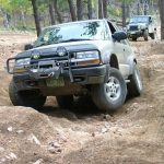
A lot of the trails in the Left Hand Canyon network had changed since we were there last so it was time to re-map the whole thing. We planned on weaving our way through Left Hand Canyon, Fireman Hill and Castle Gulch before the day was out, hitting all of the trails we found on the Motor Vehicle Use Map. We were a big group and we aired down at the trailhead where we could find the room.

We started the trail and soon parked at the intersection with the old Carnage Canyon trail. It's closed now, and just inside the posts and cable were a bunch of shooters. There were lots of empty shells underfoot as we walked a little way in.

It was nice to see that the land reclaims a trail so quickly, because the old trail was very overgrown. You couldn't even tell it used to be a road. We hiked up the hill on a new hiking trail for a little bit but then we were itching to get back to wheeling so we headed back. It was a bit of a bummer to see Carnage gone forever.

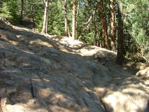
Our plan was to run up Big Momma Hill and then down the Old Playground. Big Momma Hill now has only one path to the top marked with posts and cable. Another bummer, but it is what it is. Still, we had a blast on the challenging hill.

Monica almost made it through all of the obstacles on the hill but she got high centered on the last one. Jim helped her get her winch going and she pulled herself through it. Steve would need a bit of winching help here and there too, but everyone else made it through under their own power. Big Momma Hill proved to be the most challenging part of the day, and we had a great time.

When we got to the top of the Old Playground it was a bummer to find that we couldn't drive over the rocks to continue up the hill anymore. That was always a nice obstacle, but it looks like it's permanently closed. We followed another group down the Old Playground. It had some cracks in it that could be bad if approached the wrong way but no one had any issues.

The other group got ahead of us when we stopped at Five Points for lunch. We found yet another trail closed but it was nice to see that Upper Carnage was still open. We had a nice lunch sitting in the shade of a big tree and we definitely hung out longer than we needed to. It was a gorgeous day.

After packing up our camp chairs we headed up to The Squeeze. We had heard the rumors that it had been leveled with dynamite but when we got there we found the rocks still there and still the same. Someone had cut down the tree that made it "The Squeeze" so the obstacle wasn't really risky anymore. Everyone drove right up it without any problems at all, which was definitely a change.

We soon found ourselves at the Upper Kiosk and we did both Castle Gulch and Fireman Hill. After those two trails we did Upper Carnage. That ended up being a lot of fun for a few people, especially Katie who found the rocky wash to be quite challenging. We were all smiles when we got back to the main trail just south of The Squeeze.

We turned downhill and went past Five Points again, this time taking the main trail back out. When we got to the trailhead we split the group in half, with half of us heading for the Nugget Hill trail (we didn't finish it because we ran out of daylight) and the other half heading for home. The later bunch went out for burgers in Boulder and it was a fantastic end to a fabulous day.

airing_down
big_momma_hill_part_1
big_momma_hill_part_2
big_momma_hill_part_3
big_momma_hill_part_4
big_momma_hill_part_5
bill_at_the_squeeze_part_1
bill_at_the_squeeze_part_2
bill_on_the_trail
chris_at_the_squeeze_part_1
chris_at_the_squeeze_part_2
chris_at_the_squeeze_part_3
chris_at_the_squeeze_part_4
chris_up_big_momma_hill_part_1
chris_up_big_momma_hill_part_2
chris_up_big_momma_hill_part_3
chris_up_big_momma_hill_part_4
chris_up_big_momma_hill_part_5
chris_up_big_momma_hill_part_6
curve
early_climb
five_points_part_1
five_points_part_2
fs842
fs843
gary_at_the_squeeze_part_1
gary_at_the_squeeze_part_2
gary_at_the_squeeze_part_3
gary_at_the_squeeze_part_4
gary_up_big_momma_hill_part_1
gary_up_big_momma_hill_part_2
gary_up_big_momma_hill_part_3
gary_up_big_momma_hill_part_4
gary_up_big_momma_hill_part_5
getting_to_the_squeeze
gorgeous_view
hiking_fs842_part_1
hiking_fs842_part_2
hiking_fs842_part_3
jim_at_the_squeeze_part_1
jim_at_the_squeeze_part_2
jim_on_the_trail
katie_at_the_squeeze_part_1
katie_at_the_squeeze_part_2
katie_at_the_squeeze_part_3
katie_at_the_squeeze_part_4
katie_hiking
katie_up_big_momma_hill_part_1
katie_up_big_momma_hill_part_2
katie_up_big_momma_hill_part_3
katie_up_big_momma_hill_part_4
katie_up_big_momma_hill_part_5
katie_up_big_momma_hill_part_6
katie_up_big_momma_hill_part_7
katie_up_big_momma_hill_part_8
les_as_peanut_gallery
lower_carnage_fenced_off
mark_and_his_new_tires
mark_c_at_the_squeeze_part_1
mark_c_at_the_squeeze_part_2
mark_c_at_the_squeeze_part_3
mark_c_at_the_squeeze_part_4
mark_c_at_the_squeeze_part_5
mark_c_at_the_squeeze_part_6
mark_c_at_the_squeeze_part_7
mark_c_at_the_squeeze_part_8
mark_c_at_the_squeeze_part_9
mark_c_on_the_trail
mark_c_up_big_momma_hill_part_1
mark_c_up_big_momma_hill_part_2
mark_c_up_big_momma_hill_part_3
mark_c_up_big_momma_hill_part_4
mark_c_up_big_momma_hill_part_5
mark_c_up_big_momma_hill_part_6
mark_u_at_the_squeeze_part_1
mark_u_at_the_squeeze_part_2
mark_u_at_the_squeeze_part_3
mark_u_at_the_squeeze_part_4
mark_u_at_the_squeeze_part_5
mark_u_at_the_squeeze_part_6
mark_u_is_a_big_help
mark_u_up_big_momma_hill_part_1
mark_u_up_big_momma_hill_part_2
mark_u_up_big_momma_hill_part_3
mark_u_up_big_momma_hill_part_4
mark_u_up_big_momma_hill_part_5
mark_u_up_big_momma_hill_part_6
matt_and_steve
matt_at_the_squeeze_part_1
matt_at_the_squeeze_part_2
matt_at_the_squeeze_part_3
matt_at_the_squeeze_part_4
matt_at_the_squeeze_part_5
matt_at_the_squeeze_part_6
matt_up_big_momma_hill_part_1
matt_up_big_momma_hill_part_2
matt_up_big_momma_hill_part_3
mellow_trail
near_the_top
no_shooting
parked_at_old_carnage_canyon
shooter_mess
slope
start_of_the_trail
steve_up_big_momma_hill_part_1
steve_up_big_momma_hill_part_2
steve_up_big_momma_hill_part_3
steve_up_big_momma_hill_part_4
steve_up_big_momma_hill_part_5
steve_up_big_momma_hill_part_6
steve_up_big_momma_hill_part_7
steve_up_big_momma_hill_part_8
sticker_sign
the_squeeze_part_1
the_squeeze_part_2
the_squeeze_part_3
trailhead_kiosk_part_1
trailhead_kiosk_part_2
trailhead_kiosk_part_3
trailhead_kiosk_part_4
trailhead
view
walt_at_the_squeeze_part_1
walt_at_the_squeeze_part_2
walt_at_the_squeeze_part_3
walt_at_the_squeeze_part_4
walt_at_the_squeeze_part_5
walt_at_the_squeeze_part_6
walt_up_big_momma_hill_part_1
walt_up_big_momma_hill_part_2
walt_up_big_momma_hill_part_3

Reports from Other Days: 8

Use the arrows or dots to flip through the previews of the other reports for Left Hand Canyon. Click one of them to read more and see all of the photos from that day.

September 30, 2007

Led by Monica I.
We had already finished Carnage Canyon and Fireman Hill, and now we were ready to explore the upper section of Left Hand Canyon (we would be skipping the lower section this time). We chatted with some people at Five Points, and then we started exploring. Right before we were going…
»
  • 1
  • 2
  • 3
  • 4
  • 5
  • 6
  • 7
  • 8
Join Us!
If you aren’t a Member or Subscriber, you can’t see all of the content on this site. Get membership information to see why this site is best when you join and log in

Information for Subscribers

When you log in you’ll see more information here:

  • Recent Community Forum posts
  • Recent polls
  • Upcoming Events you can attend
  • Links to online users

© 2000-2023 · TrailDamage.com · Terms and Conditions · About · Contact
Trail information is only accurate on the date posted. Trails may have changed or closed since that date. Use this information for historical purposes only.
Contact the Forest Service or Bureau of Land Management for up-to-date trail information.

/* ----------------------------------------- */ /* View slug: reports-other-reports-for-same-trail-slider - start */ /* ----------------------------------------- */ /* place the prev/next controls on the sides */ .td-transition-controls .wpv-filter-next-link, .td-transition-controls .wpv-filter-previous-link { border: none; font-size: 300%; position: absolute; top: 70px; } .td-transition-controls .wpv-filter-previous-link { left: 0; } .td-transition-controls .wpv-filter-next-link { right: 0; } /* center the page selector horizonatally */ .td-transition-controls ul.wpv_pagination_dots { text-align: center; margin-top: 10px; } /* center the page selector horizonatally */ .td-transition-controls ul.wpv_pagination_dots li.wpv_pagination_dots_item, .td-transition-controls .wpv_pagination_dots li a { display: inline-block; float: none; } /* remove the default styles */ .td-transition-controls .wpv_pagination_dots li a { text-decoration: none; border-bottom: none; } .td-slider-container { padding: 0 25px; margin-bottom: 20px; position: relative; width:100%; display:table; } .td-slides { position: relative; } .td-slides-image { float:left; display:table-cell; } .td-slides-image img { border:1px solid #c0c0c0; } .td-slides-content { padding:4px 4px 4px 10px; border-top:1px solid #c0c0c0; border-right:1px solid #c0c0c0; border-bottom:1px solid #c0c0c0; display:table-cell; height:227px; overflow:hidden; } .td-slides-content h3 { margin-top:8px; } .td-slides-leader { font-size:smaller; margin-top:4px; } /* ----------------------------------------- */ /* View slug: reports-other-reports-for-same-trail-slider - end */ /* ----------------------------------------- */
/* ----------------------------------------- */ /* Content Template: Template for a Single Report - start */ /* ----------------------------------------- */ .entry-header { display:none; } .entry-content h1 { margin-top:16px; padding-top:0; } h1 a { color:#222; } h1 a:hover { color:#666; } p.entry-meta { font-size:small; } #report-body-spacer { clear:both; width:100%; height:20px; } #addtoany-bar { margin-bottom:2em; text-align:center; } .category-reports .post-info .author, .post-info .date { display: none; } .addthis_recommended_horizontal { text-align:center !important; } /* ----------------------------------------- */ /* Content Template: Template for a Single Report - end */ /* ----------------------------------------- */ /* ----------------------------------------- */ /* Content Template: Loop item in REPORTS Runners - start */ /* ----------------------------------------- */ #runners-container { width:100%; clear:both; } .runner { border:1px solid #c0c0c0; margin:0 6px 6px 0; float:left; width:49%; height:81px; } .runner-image { float: left; } .runner-image img { margin:2px 10px 0 2px; height:75px; width:75px; } .runner-name { text-transform:uppercase; } .runner-name a { color:#222; } .runner-name a:hover { color:#666; } .runner-vehicle { font-size:small; } @media only screen and (max-width: 768px) { .runner { width:100%; } } /* ----------------------------------------- */ /* Content Template: Loop item in REPORTS Runners - end */ /* ----------------------------------------- */