TrailDamage.com

Photos, videos and information about 4x4 trails in Colorado and Utah

  • Trails
    • Colorado
    • Utah
  • Reports
    • Featured Photos
    • Featured Videos
    • Reports Calendar
  • Members
  • Search
  • Trail Damage Winners
  • FAQ
  • Community
  • Upcoming Events
  • Membership
  • Log In
  • Facebook
  • Instagram
  • RSS
  • Twitter
  • YouTube

La Sal Pass 130902

September 2, 2013 by Monica

La Sal Pass

Trail Run on September 2, 2013
Report and photos by Monica I., Trail Leader
View trail information for La Sal Pass

Matt K.
White 2016 Jeep Wrangler Unlimited Rubicon
Monica I.
Red 2010 Jeep Wrangler Rubicon
Julie M.
Green 2012 Jeep Wrangler Unlimited Rubicon
Les L.
Gray 2006 Nissan Frontier

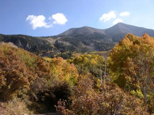
We don't usually spend time in the Moab desert in August and early September. We will wait until October, usually, so the temperatures are cooler. 2013 saw us baking in the Utah sun late in August on White Rim and in Canyonlands National Park, and we contemplated another day of wheeling in the heat. We thought about doing a boat ride instead, but the times didn't work out. Then we had the bright idea to head up to the La Sal Mountains and it worked perfectly.

We wanted to do the loop of La Sal Pass and Geyser Pass, and we randomly chose to do La Sal Pass first. That ended up being the best choice. The climb up the pass was fun and rocky in spots. We started out on the fence about airing down, but then we were glad we did. It was definitely bumpy on the way up.

We crossed the creek without incident, even though we had a minor run-in with a cow. When we got to a wide spot, we all parked and got out to stretch our legs and the scenery was fantastic. Everything was very green, and there were even flowers in places. The temperatures were perfect, too, and it was such a nice break from the heat. We hung out for a while just enjoying the area.

We got up to the pass and we slowed down for some pictures but no one got out. Then we took the spur to Medicine Lakes and that was the highlight of the trail. We parked in the parking area and walked to the nearest lake, and it was so very perfect. The water was calm, with a duck enjoying the cool water. The mountains reflected off of the lake and it was very picturesque. We talked about how we could camp near the lake, but it was a long distance to haul our large amount of stuff. We were happy to settle for a day hike.

After the lakes the trail seemed to go by very quickly. Even though it's a big distance, it didn't seem to take long to get to the intersection with Geyser Pass. We all headed to the Geyser Pass trailhead and the parking area there to discuss plans. Matt had to head for home, and Les was done wheeling for the day. We said our goodbyes, and Julie and Monica headed off to do some more trails. It was a great trip through the mountains.

adopted
aspens_part_1
aspens_part_2
aspens_part_3
aspens_part_4
aspens_part_5
aspens_part_6
big_view
blue_sky
break_time
bumpy
carsonite
chunky
climbing
cloud_shadows
colors
cows
creek
curve
down_the_other_side
exposed
flowers
green
happy_boys
julie_on_the_trail
jungle-like
les_on_the_trail
loose_rock
matt_on_the_trail
medicine_lakes_part_1
medicine_lakes_part_2
medicine_lakes_part_3
medicine_lakes_part_4
medicine_lakes_part_5
medicine_lakes_pit_toilet
medicine_lakes_sign
monica_loaded_up
monica_on_the_trail
moss
mount_tukuhnikivatz_part_1
mount_tukuhnikivatz_part_2
mountain_scenery
near_timberline
on_the_way
open_space
parked_at_medicine_lakes
pass_panorama
pass
pond
pretty
puddle
red_and_green
rocky
scenic
see_for_miles
shaded
shelf
side_of_a_hill
start_of_the_trail
sun_and_shadows
the_end
thick
through_brush
tippy
to_beaver_lake
to_the_top
trail_ahead
warning_sign
waves
yellow

Report from a Different Day

October 8, 2005

Led by Mike S.
The majority of the TrailDamage members were going to run Pritchett Canyon, but others opted for something a little less daunting. We met at the McDonald’s at the designated time and discussed our options. The original plan had been to run Fins & Things, followed by Hell’s Revenge. We changed…
Join Us!
If you aren’t a Member or Subscriber, you can’t see all of the content on this site. Get membership information to see why this site is best when you join and log in

Information for Subscribers

When you log in you’ll see more information here:

  • Recent Community Forum posts
  • Recent polls
  • Upcoming Events you can attend
  • Links to online users

© 2000-2022 · TrailDamage.com · Terms and Conditions · About · Contact
Trail information is only accurate on the date posted. Trails may have changed or closed since that date. Use this information for historical purposes only.
Contact the Forest Service or Bureau of Land Management for up-to-date trail information.

/* ----------------------------------------- */ /* View slug: reports-other-reports-for-same-trail-slider - start */ /* ----------------------------------------- */ /* place the prev/next controls on the sides */ .td-transition-controls .wpv-filter-next-link, .td-transition-controls .wpv-filter-previous-link { border: none; font-size: 300%; position: absolute; top: 70px; } .td-transition-controls .wpv-filter-previous-link { left: 0; } .td-transition-controls .wpv-filter-next-link { right: 0; } /* center the page selector horizonatally */ .td-transition-controls ul.wpv_pagination_dots { text-align: center; margin-top: 10px; } /* center the page selector horizonatally */ .td-transition-controls ul.wpv_pagination_dots li.wpv_pagination_dots_item, .td-transition-controls .wpv_pagination_dots li a { display: inline-block; float: none; } /* remove the default styles */ .td-transition-controls .wpv_pagination_dots li a { text-decoration: none; border-bottom: none; } .td-slider-container { padding: 0 25px; margin-bottom: 20px; position: relative; width:100%; display:table; } .td-slides { position: relative; } .td-slides-image { float:left; display:table-cell; } .td-slides-image img { border:1px solid #c0c0c0; } .td-slides-content { padding:4px 4px 4px 10px; border-top:1px solid #c0c0c0; border-right:1px solid #c0c0c0; border-bottom:1px solid #c0c0c0; display:table-cell; height:227px; overflow:hidden; } .td-slides-content h3 { margin-top:8px; } .td-slides-leader { font-size:smaller; margin-top:4px; } /* ----------------------------------------- */ /* View slug: reports-other-reports-for-same-trail-slider - end */ /* ----------------------------------------- */
/* ----------------------------------------- */ /* Content Template: Template for a Single Report - start */ /* ----------------------------------------- */ .entry-header { display:none; } .entry-content h1 { margin-top:16px; padding-top:0; } h1 a { color:#222; } h1 a:hover { color:#666; } p.entry-meta { font-size:small; } #report-body-spacer { clear:both; width:100%; height:20px; } #addtoany-bar { margin-bottom:2em; text-align:center; } .category-reports .post-info .author, .post-info .date { display: none; } .addthis_recommended_horizontal { text-align:center !important; } /* ----------------------------------------- */ /* Content Template: Template for a Single Report - end */ /* ----------------------------------------- */ /* ----------------------------------------- */ /* Content Template: Loop item in REPORTS Runners - start */ /* ----------------------------------------- */ #runners-container { width:100%; clear:both; } .runner { border:1px solid #c0c0c0; margin:0 6px 6px 0; float:left; width:49%; height:81px; } .runner-image { float: left; } .runner-image img { margin:2px 10px 0 2px; height:75px; width:75px; } .runner-name { text-transform:uppercase; } .runner-name a { color:#222; } .runner-name a:hover { color:#666; } .runner-vehicle { font-size:small; } @media only screen and (max-width: 768px) { .runner { width:100%; } } /* ----------------------------------------- */ /* Content Template: Loop item in REPORTS Runners - end */ /* ----------------------------------------- */