TrailDamage.com

Photos, videos and information about 4x4 trails in Colorado and Utah

  • Trails
    • Colorado
    • Utah
  • Reports
    • Featured Photos
    • Featured Videos
    • Reports Calendar
  • Members
  • Search
  • Trail Damage Winners
  • FAQ
  • Community
  • Upcoming Events
  • Membership
  • Log In
  • Facebook
  • Instagram
  • RSS
  • Twitter
  • YouTube

Kingston Peak 040717

July 17, 2004 by Monica

Kingston Peak

Trail Run on July 17, 2004
Report and photos by Monica I., Trail Leader
View trail information for Kingston Peak

Bob S.
Green 1997 Jeep Wrangler
Jon G.
Khaki 2003 Jeep Wrangler
Monica I.
Red 2010 Jeep Wrangler Rubicon
Gary R.
Yellow 1978 Jeep CJ-7
Dave B.
Black 2004 Jeep Wrangler Rubicon

We ran this trail after Jenny Creek without planning it in advance -- we ended up with extra time. Bob was leading the second group on Jenny Creek and we waited for him so he could run Kingston Peak with us. When we started the trail outside of Rollinsville it was already raining pretty hard.

As we worked our way up the trail it really started pouring. The muddy water was running down the middle of the trail and it was almost hard to see at times. It was a lot of rain, but luckily it didn't hail. There were a couple lightening strikes nearby but we kept going.

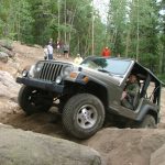
The rain had died down a little bit when we got to the mud puddles. The puddles are usually pretty big anyway, but with all the rain they were really wet and deep. They were better than usual because this mud is usually very thick and greasy, but this time it was pretty watery.

Dave, Bob, Jon and Gary went around and around, splashing through all of the puddles. Bob got enough water and mud in his system to actually start smoking and sputtering, but his Jeep hung in there.

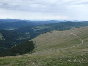
We came around to the long part of the trail on the side of the mountain, and saw some vehicles parked way up ahead at the overlook. There wasn't anyone coming so we started across. The clouds came in and it got really foggy, making the trip over to the switchback a little creepy.

We passed the vehicles (no people) and started up the hill to the peak. What used to be lots of whoopdeedoos and a little bit of a challenge ended up being a flat hill with some loose rocks and no real challenge (not like before). It was extremely foggy on the way up, though.

When we got to the valley Dave was running really late so he got ahead of us and went on his own. We all got to the big hill to the next peak and made it to the top without any issues.

We stopped to put rocks on the rock walls for luck, taking pictures of Loch Lomond. The weather was still cold but it stopped raining (only a little drizzle).

We warmed up at Beau Jo's in Idaho Springs with some pizza, which is always good. It was a wet and foggy trail but it was a good run.

bob_in_the_mud_part_1
bob_in_the_mud_part_2
bob_in_the_mud_part_3
bob_in_the_mud_part_4
bob_in_the_mud_part_5
bob_in_the_mud_part_6
bob_mike_and_gary
bob_posing
cars_at_the_overlook
clouds
cloudy
dave_in_the_mud_part_1
dave_in_the_mud_part_2
dave_in_the_mud_part_3
everyone_on_the_trail
gary_in_the_mud_part_1
gary_in_the_mud_part_2
gary_in_the_mud_part_3
gary_in_the_mud_part_4
gary_on_the_trail
jon_in_the_mud_part_1
jon_in_the_mud_part_2
jon_in_the_mud_part_3
jon_in_the_mud_part_4
jon_on_the_trail
loch_lomond_part_1
loch_lomond_part_2
snow
thick_fog
wildflowers

Reports from Other Days: 10

Use the arrows or dots to flip through the previews of the other reports for Kingston Peak. Click one of them to read more and see all of the photos from that day.

July 16, 2016

Led by Monica I.
We knew better than to run Kingston Peak from south to north. The trail is just fine in that direction, but finding the southern end is always way too difficult. To make matters worse, we came off of Yankee Hill and went farther north into Alice, getting us turned around…
« »
  • 1
  • 2
  • 3
  • 4
  • 5
  • 6
  • 7
  • 8
  • 9
  • 10
Join Us!
If you aren’t a Member or Subscriber, you can’t see all of the content on this site. Get membership information to see why this site is best when you join and log in

Information for Subscribers

When you log in you’ll see more information here:

  • Recent Community Forum posts
  • Recent polls
  • Upcoming Events you can attend
  • Links to online users

© 2000-2023 · TrailDamage.com · Terms and Conditions · About · Contact
Trail information is only accurate on the date posted. Trails may have changed or closed since that date. Use this information for historical purposes only.
Contact the Forest Service or Bureau of Land Management for up-to-date trail information.

/* ----------------------------------------- */ /* View slug: reports-other-reports-for-same-trail-slider - start */ /* ----------------------------------------- */ /* place the prev/next controls on the sides */ .td-transition-controls .wpv-filter-next-link, .td-transition-controls .wpv-filter-previous-link { border: none; font-size: 300%; position: absolute; top: 70px; } .td-transition-controls .wpv-filter-previous-link { left: 0; } .td-transition-controls .wpv-filter-next-link { right: 0; } /* center the page selector horizonatally */ .td-transition-controls ul.wpv_pagination_dots { text-align: center; margin-top: 10px; } /* center the page selector horizonatally */ .td-transition-controls ul.wpv_pagination_dots li.wpv_pagination_dots_item, .td-transition-controls .wpv_pagination_dots li a { display: inline-block; float: none; } /* remove the default styles */ .td-transition-controls .wpv_pagination_dots li a { text-decoration: none; border-bottom: none; } .td-slider-container { padding: 0 25px; margin-bottom: 20px; position: relative; width:100%; display:table; } .td-slides { position: relative; } .td-slides-image { float:left; display:table-cell; } .td-slides-image img { border:1px solid #c0c0c0; } .td-slides-content { padding:4px 4px 4px 10px; border-top:1px solid #c0c0c0; border-right:1px solid #c0c0c0; border-bottom:1px solid #c0c0c0; display:table-cell; height:227px; overflow:hidden; } .td-slides-content h3 { margin-top:8px; } .td-slides-leader { font-size:smaller; margin-top:4px; } /* ----------------------------------------- */ /* View slug: reports-other-reports-for-same-trail-slider - end */ /* ----------------------------------------- */
/* ----------------------------------------- */ /* Content Template: Template for a Single Report - start */ /* ----------------------------------------- */ .entry-header { display:none; } .entry-content h1 { margin-top:16px; padding-top:0; } h1 a { color:#222; } h1 a:hover { color:#666; } p.entry-meta { font-size:small; } #report-body-spacer { clear:both; width:100%; height:20px; } #addtoany-bar { margin-bottom:2em; text-align:center; } .category-reports .post-info .author, .post-info .date { display: none; } .addthis_recommended_horizontal { text-align:center !important; } /* ----------------------------------------- */ /* Content Template: Template for a Single Report - end */ /* ----------------------------------------- */ /* ----------------------------------------- */ /* Content Template: Loop item in REPORTS Runners - start */ /* ----------------------------------------- */ #runners-container { width:100%; clear:both; } .runner { border:1px solid #c0c0c0; margin:0 6px 6px 0; float:left; width:49%; height:81px; } .runner-image { float: left; } .runner-image img { margin:2px 10px 0 2px; height:75px; width:75px; } .runner-name { text-transform:uppercase; } .runner-name a { color:#222; } .runner-name a:hover { color:#666; } .runner-vehicle { font-size:small; } @media only screen and (max-width: 768px) { .runner { width:100%; } } /* ----------------------------------------- */ /* Content Template: Loop item in REPORTS Runners - end */ /* ----------------------------------------- */