TrailDamage.com

Photos, videos and information about 4x4 trails in Colorado and Utah

  • Trails
    • Colorado
    • Utah
  • Reports
    • Featured Photos
    • Featured Videos
    • Reports Calendar
  • Members
  • Search
  • Trail Damage Winners
  • FAQ
  • Community
  • Upcoming Events
  • Membership
  • Log In
  • Facebook
  • Instagram
  • RSS
  • Twitter
  • YouTube

Italian Creek 120811

August 11, 2012 by Monica

Italian Creek

Trail Run on August 11, 2012
Report and photos by Monica I., Trail Leader
View trail information for Italian Creek

Walt S.
Gray 2022 Jeep Wrangler Unlimited Rubicon 392
Monica I.
Red 2010 Jeep Wrangler Rubicon
Bob S.
Green 1997 Jeep Wrangler
Ben P.
Green 2012 Jeep Wrangler Unlimited Rubicon

Our last trip to Italian Creek found us on Reno Divide but skipping American Flag Mountain, so we planned on reversing that this trip. We had spent a wonderful morning on Cement Creek, and we turned onto Italian Creek already smiling. The place was packed with bicycles, ATVs, hikers, dirtbikes, and other 4x4 vehicles. A truck full of bicycles and passengers even went by, taking them to the top so they could have an easier ride down. Even with the constant parade we had a great time.

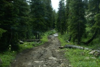
The first section of the trail is mostly in the trees, and it was cool and shady. We worked our way through groups of bicycles and kept climbing. It was noon and we found a wide, flat spot for a nice lunch. Then we kept going.

It was a quick trip to the fence and gate at the intersection with Reno Divide. When we got there, a parade of dirtbikes and ATVs were there. A nice guy opened the gate for us, and we stayed on the Italian Creek trail. We'll do Reno Divide again but it won't be until the next time.

The section of Italian Creek between the Reno Divide intersections is almost always narrow. There were very few places to pass. Luckily, it seemed that the parade was up on Reno Divide because we didn't see anyone. We stopped at the overlook for a bit to take pictures and stretch our legs, and we had it to ourselves.

After the overlook we started out again and it started raining. Then the lightning and thunder started, and the storm was close. It got chilly, but luckily it didn't last for too long. We all spent time putting our Jeep tops up and then down and then up again.

The intersection with Reno Divide meant that the trail was going to open up, and it did. We were out of the trees for a while, and back with the parade of other people enjoying the trail. We passed by the Stewart Mine and talked about the last time we stopped there for lunch. It's definitely a nice spot.

And finally we were at American Flag Mountain. We headed up and managed not to find any traffic coming down. It kept getting chillier and windier, and by the time we got to the top it was really windy, 55 degrees, and raining. It really felt like summer was ending. We enjoyed the scenery anyway, and watched people come up to join us.

But then the weather changed. It stopped raining, the wind mellowed out a bit, and the sun came out. Perfect! We stayed even longer taking more pictures of the scenery. There is another wide, flat spot halfway down and we stopped there too for more pictures and hanging out. Monica's sway bar link had come undone so Walt loaned her a cotter pin.

It was really nice on the mountain but we finally agreed it was time to head back down. We made it back to the main trail without having to dodge uphill traffic, and soon we were on our way.

We were following the forest service's motor vehicle use maps, so we took a spur to Star Mine that they had mapped. We didn't make it far, though, because it was closed halfway up by someone other than the forest service. It was very difficult to turn around, and we discovered barbed wire in the brush in the process. Luckily, no one got tangled up in it and no one was hurt. We worked our way back to the main trail.

At that intersection there was a nice, deep puddle of muddy water. We normally avoid those, but something was weird that day. We went back and forth through it multiple times like we didn't know any better. Each of us ended up with muddy water related issues by the time we were done. Lesson learned (again)!

After the mud puddle we headed out around the private property and out to the main road. It seemed to take forever. Three of us mapped the way back to Crested Butte on our GPS units. Bob's said it was 20 minutes, Monica's said three hours, and Ben's was in between the two others. We talked at length about different routes back to town, but in the end we just took the easiest way.

At county road 742 we turned right to head back. We discussed wandering around on the trail that goes by Boston Peak, but we were really out of time. We went by Taylor Park Reservoir and out, and we got back to Crested Butte in time for dinner before the restaurants closed. It was a great day!

alpine_view
aspens_in_rocks
aspens
ben_and_bob
ben_at_lunch
ben_down_american_flag_mountain_part_1
ben_down_american_flag_mountain_part_2
ben_down_american_flag_mountain_part_3
ben_in_scenery
ben_in_the_mud_part_1
ben_in_the_mud_part_2
ben_in_the_mud_part_3
ben_in_the_mud_part_4
ben_in_the_mud_part_5
ben_in_the_mud_part_6
ben_in_the_mud_part_7
ben_in_the_mud_part_8
bob_and_ben
bob_at_lunch
bob_at_the_overlook
bob_on_amercan_flag_mountain
bumpy
chunky
climbing_rocks
climbing
collegiate_peaks
curious_deer
dead_trees
deer
down_american_flag_mountain
early_climb
eastern_intersection_with_reno_divide
easy_trail
exposed
forest_service_sign
friendly_sign
georgeous
good_rocks
group_shot_at_the_overlook
happy_rock
hillside
italian_connector_trail
italian_creek_sign
italian_creek
jeeps
lily_pond_trail
long_and_mellow
long_view
look_over_there
loose_climb
lunch
mining_buildings
monica_at_lunch
monica_at_the_overlook
monica_in_scenery
monica_in_the_mud_part_1
monica_in_the_mud_part_2
monica_in_the_mud_part_3
monica_in_the_mud_part_4
monica_in_the_mud_part_5
monica_in_the_mud_part_6
monica_in_the_mud_part_7
monica_in_the_mud_part_8
monica_on_american_flag_mountain
muddy_and_bumpy
old_cabin
old_machinery
on_american_flag_mountain_part_1
on_american_flag_mountain_part_2
parked_at_the_edge
patches_of_blue_sky
pond_near_the_overlook
private_property
rain_clouds
rocks_in_the_trail
rocky_trail
side_of_a_hill
sign_at_the_end
sunshine
tailings
tall_trees
trail_with_a_view
trailhead_sign
up_american_flag_mountain
view_from_american_flag_mountain_part_1
view_from_american_flag_mountain_part_2
view_from_american_flag_mountain_part_3
view_from_american_flag_mountain_part_4
view_from_american_flag_mountain_part_5
view_from_american_flag_mountain_part_6
view_from_american_flag_mountain_part_7
view_from_american_flag_mountain_part_8
view_from_american_flag_mountain_part_9
view_from_the_overlook
view_in_trees
walt_and_ben
walt_at_lunch
walt_down_american_flag_mountain_part_1
walt_down_american_flag_mountain_part_2
walt_in_the_mud_part_1
walt_in_the_mud_part_2
walt_in_the_mud_part_3
walt_in_the_mud_part_4
walt_in_the_mud_part_5
walt_in_the_mud_part_6
walt_in_the_mud_part_7
walt_in_the_mud_part_8
walt_in_the_mud_part_9
walt_muddy_part_1
walt_muddy_part_2
walt_muddy_part_3
walt_on_the_trail

Reports from Other Days: 2

Use the arrows or dots to flip through the previews of the other reports for Italian Creek. Click one of them to read more and see all of the photos from that day.

July 26, 2009

Led by Mike S.
Italian Creek had a lot of puddles and mud on the trail due to the rain from the night before. Travel was nice and easy, though, and we passed some ATVs along the way. We enjoyed reading the private property signs up in the basin below American Flag Mountain. At…
»
  • 1
  • 2
Join Us!
If you aren’t a Member or Subscriber, you can’t see all of the content on this site. Get membership information to see why this site is best when you join and log in

Information for Subscribers

When you log in you’ll see more information here:

  • Recent Community Forum posts
  • Recent polls
  • Upcoming Events you can attend
  • Links to online users

© 2000-2023 · TrailDamage.com · Terms and Conditions · About · Contact
Trail information is only accurate on the date posted. Trails may have changed or closed since that date. Use this information for historical purposes only.
Contact the Forest Service or Bureau of Land Management for up-to-date trail information.

/* ----------------------------------------- */ /* View slug: reports-other-reports-for-same-trail-slider - start */ /* ----------------------------------------- */ /* place the prev/next controls on the sides */ .td-transition-controls .wpv-filter-next-link, .td-transition-controls .wpv-filter-previous-link { border: none; font-size: 300%; position: absolute; top: 70px; } .td-transition-controls .wpv-filter-previous-link { left: 0; } .td-transition-controls .wpv-filter-next-link { right: 0; } /* center the page selector horizonatally */ .td-transition-controls ul.wpv_pagination_dots { text-align: center; margin-top: 10px; } /* center the page selector horizonatally */ .td-transition-controls ul.wpv_pagination_dots li.wpv_pagination_dots_item, .td-transition-controls .wpv_pagination_dots li a { display: inline-block; float: none; } /* remove the default styles */ .td-transition-controls .wpv_pagination_dots li a { text-decoration: none; border-bottom: none; } .td-slider-container { padding: 0 25px; margin-bottom: 20px; position: relative; width:100%; display:table; } .td-slides { position: relative; } .td-slides-image { float:left; display:table-cell; } .td-slides-image img { border:1px solid #c0c0c0; } .td-slides-content { padding:4px 4px 4px 10px; border-top:1px solid #c0c0c0; border-right:1px solid #c0c0c0; border-bottom:1px solid #c0c0c0; display:table-cell; height:227px; overflow:hidden; } .td-slides-content h3 { margin-top:8px; } .td-slides-leader { font-size:smaller; margin-top:4px; } /* ----------------------------------------- */ /* View slug: reports-other-reports-for-same-trail-slider - end */ /* ----------------------------------------- */
/* ----------------------------------------- */ /* Content Template: Template for a Single Report - start */ /* ----------------------------------------- */ .entry-header { display:none; } .entry-content h1 { margin-top:16px; padding-top:0; } h1 a { color:#222; } h1 a:hover { color:#666; } p.entry-meta { font-size:small; } #report-body-spacer { clear:both; width:100%; height:20px; } #addtoany-bar { margin-bottom:2em; text-align:center; } .category-reports .post-info .author, .post-info .date { display: none; } .addthis_recommended_horizontal { text-align:center !important; } /* ----------------------------------------- */ /* Content Template: Template for a Single Report - end */ /* ----------------------------------------- */ /* ----------------------------------------- */ /* Content Template: Loop item in REPORTS Runners - start */ /* ----------------------------------------- */ #runners-container { width:100%; clear:both; } .runner { border:1px solid #c0c0c0; margin:0 6px 6px 0; float:left; width:49%; height:81px; } .runner-image { float: left; } .runner-image img { margin:2px 10px 0 2px; height:75px; width:75px; } .runner-name { text-transform:uppercase; } .runner-name a { color:#222; } .runner-name a:hover { color:#666; } .runner-vehicle { font-size:small; } @media only screen and (max-width: 768px) { .runner { width:100%; } } /* ----------------------------------------- */ /* Content Template: Loop item in REPORTS Runners - end */ /* ----------------------------------------- */