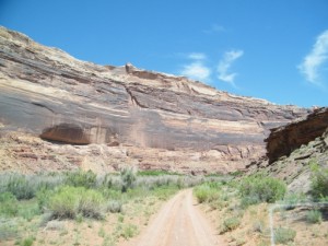
TrailDamage.com

Photos, videos and information about 4x4 trails in Colorado and Utah

  • Trails
    • Colorado
    • Utah
  • Reports
    • Featured Photos
    • Featured Videos
    • Reports Calendar
  • Members
  • Search
  • Trail Damage Winners
  • FAQ
  • Community
  • Upcoming Events
  • Membership
  • Log In
  • Facebook
  • Instagram
  • RSS
  • Twitter
  • YouTube

Hey Joe Canyon 041014

October 14, 2004 by Monica

Hey Joe Canyon

Trail Run on October 14, 2004
Report and photos by Monica I., Trail Leader
View trail information for Hey Joe Canyon

Steve G.
Gold 1999 Chevrolet Blazer
Ladd G.
Green 2003 Jeep Wrangler Rubicon
Monica I.
Red 2010 Jeep Wrangler Rubicon
Bob S.
Green 1997 Jeep Wrangler

The Wells book describes this as a difficult trail so we wanted to check it out. It didn't turn out to be difficult at all. Instead, it ended up being quite a nightmare of trees and bushes and we all ended up with scratched paint on the outside with trees and bugs on the inside. We're all undecided about whether or not the mine at the end made it all worth it.

Spring Canyon Bottom was mellow but gorgeous. It was cool how close the Green River was when we started the Hey Joe Canyon trail, but you couldn't always see it. Most of the time you were entirely surrounded by trees and bushes. Some of the trees were actually pretty big.

Steve slammed into a hole pretty hard, starting a weekend of scooping up sand with his winch every chance he got. Some of the rocks were pretty cool, making for some decent obstacles. Nothing was difficult, however.

We were all about over it by the time we got to the mine. People either had scratched Jeep windows or a mountain of greenery in their vehicles. Steve was lucky with glass windows, though his Blazer was larger and made for more scratches.

We went into the mine for a little bit, then came back out to get the rest of the group and some more flashlights. We explored quite a bit of the mine, finding actual uranium (redish-colored rock) and sulfur (yellowish-colored rock). We took some pictures at the very end. It was cool in temperature but also very humid, and we were all winded and coughing when we came out due to the dust inside.

We groaned about having to go back out as we ate lunch outside the mine. We made it back out, with more bugs in the afternoon. It was a cool trail with the mine at the end, though I doubt we'll be doing this trail again.

barrel
bob_and_steve
bob_in_the_mine_part_1
bob_in_the_mine_part_2
bob_in_the_mine_part_3
climb_up_hey_joe_canyon
collapsed_section
disintegrated_tire
early_view_of_the_river
end_of_the_trail
ladder
lucky_wood_plank
lunch_part_1
lunch_part_2
lunch_part_3
lunch_part_4
mine_entrance
mine_holes
mine_shaft_part_1
mine_shaft_part_10
mine_shaft_part_11
mine_shaft_part_12
mine_shaft_part_13
mine_shaft_part_14
mine_shaft_part_2
mine_shaft_part_3
mine_shaft_part_4
mine_shaft_part_5
mine_shaft_part_6
mine_shaft_part_7
mine_shaft_part_8
mine_shaft_part_9
mine_wall
mining_equipment
monica_on_the_trail
monica_with_trees
old_equipment
old_truck
pick_axe_handle
rocky_trail
steve_in_the_mine
steve_looking_up_a_ladder
strip_of_sulfur
sulfur
uranium

Report from a Different Day

May 20, 2010

Led by Monica I.
We still talk about our last trip to Hey Joe Canyon. We all said we’d never do it again. The tamerisk was all over the place and trees hit our vehicles. It was difficult to drive through and bugs were everywhere. But we’d heard that the tamerisk was under a…
Join Us!
If you aren’t a Member or Subscriber, you can’t see all of the content on this site. Get membership information to see why this site is best when you join and log in

Information for Subscribers

When you log in you’ll see more information here:

  • Recent Community Forum posts
  • Recent polls
  • Upcoming Events you can attend
  • Links to online users

© 2000-2021 · TrailDamage.com · Terms and Conditions · About · Contact
Trail information is only accurate on the date posted. Trails may have changed or closed since that date. Use this information for historical purposes only.
Contact the Forest Service or Bureau of Land Management for up-to-date trail information.

/* ----------------------------------------- */ /* View slug: reports-other-reports-for-same-trail-slider - start */ /* ----------------------------------------- */ /* place the prev/next controls on the sides */ .td-transition-controls .wpv-filter-next-link, .td-transition-controls .wpv-filter-previous-link { border: none; font-size: 300%; position: absolute; top: 70px; } .td-transition-controls .wpv-filter-previous-link { left: 0; } .td-transition-controls .wpv-filter-next-link { right: 0; } /* center the page selector horizonatally */ .td-transition-controls ul.wpv_pagination_dots { text-align: center; margin-top: 10px; } /* center the page selector horizonatally */ .td-transition-controls ul.wpv_pagination_dots li.wpv_pagination_dots_item, .td-transition-controls .wpv_pagination_dots li a { display: inline-block; float: none; } /* remove the default styles */ .td-transition-controls .wpv_pagination_dots li a { text-decoration: none; border-bottom: none; } .td-slider-container { padding: 0 25px; margin-bottom: 20px; position: relative; width:100%; display:table; } .td-slides { position: relative; } .td-slides-image { float:left; display:table-cell; } .td-slides-image img { border:1px solid #c0c0c0; } .td-slides-content { padding:4px 4px 4px 10px; border-top:1px solid #c0c0c0; border-right:1px solid #c0c0c0; border-bottom:1px solid #c0c0c0; display:table-cell; height:227px; overflow:hidden; } .td-slides-content h3 { margin-top:8px; } .td-slides-leader { font-size:smaller; margin-top:4px; } /* ----------------------------------------- */ /* View slug: reports-other-reports-for-same-trail-slider - end */ /* ----------------------------------------- */
/* ----------------------------------------- */ /* Content Template: Template for a Single Report - start */ /* ----------------------------------------- */ .entry-header { display:none; } .entry-content h1 { margin-top:16px; padding-top:0; } h1 a { color:#222; } h1 a:hover { color:#666; } p.entry-meta { font-size:small; } #report-body-spacer { clear:both; width:100%; height:20px; } #addtoany-bar { margin-bottom:2em; text-align:center; } .category-reports .post-info .author, .post-info .date { display: none; } .addthis_recommended_horizontal { text-align:center !important; } /* ----------------------------------------- */ /* Content Template: Template for a Single Report - end */ /* ----------------------------------------- */ /* ----------------------------------------- */ /* Content Template: Loop item in REPORTS Runners - start */ /* ----------------------------------------- */ #runners-container { width:100%; clear:both; } .runner { border:1px solid #c0c0c0; margin:0 6px 6px 0; float:left; width:49%; height:81px; } .runner-image { float: left; } .runner-image img { margin:2px 10px 0 2px; height:75px; width:75px; } .runner-name { text-transform:uppercase; } .runner-name a { color:#222; } .runner-name a:hover { color:#666; } .runner-vehicle { font-size:small; } @media only screen and (max-width: 768px) { .runner { width:100%; } } /* ----------------------------------------- */ /* Content Template: Loop item in REPORTS Runners - end */ /* ----------------------------------------- */