TrailDamage.com

Photos, videos and information about 4x4 trails in Colorado and Utah

  • Trails
    • Colorado
    • Utah
  • Reports
    • Featured Photos
    • Featured Videos
    • Reports Calendar
  • Members
  • Search
  • Trail Damage Winners
  • FAQ
  • Community
  • Upcoming Events
  • Membership
  • Log In
  • Facebook
  • Instagram
  • RSS
  • Twitter
  • YouTube

Hermit Pass 050807

August 7, 2005 by Monica

Hermit Pass

Trail Run on August 7, 2005
Report and photos by Monica I., Trail Leader
View trail information for Hermit Pass

Bob S.
Green 1997 Jeep Wrangler
Monica I.
Red 2010 Jeep Wrangler Rubicon

We ran this trail last on our way back to Denver from an exciting weekend trip in the Alamosa area. We started with Hayden Pass, did Blanca Peak the next day, then started our morning with Medano Pass. Monica and Bob S. were the only ones to do Hermit Pass and we were welcomed with a gorgeous trail and an awesome finish to our trip.

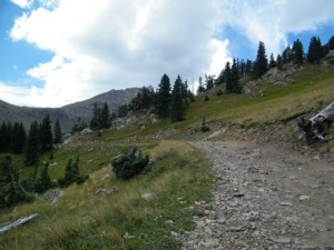
We aired down for the bumpy, rocky trail and enjoyed the rocks on the way up. We talked about how much fun the trail would be for someone new to wheeling and how this kind of trail would have been scary at one point not too long ago. It has some good-sized rocks here and there that you need to go over or around. Luckily the trail is usually wide while you're still below timberline.

We saw a few ATVs and a few stock SUVs coming up and down. This trail would be quite challenging for a stock SUV.

We popped out of the trees and were surprised to find a big, open area with our trail stretching into the distance. The views of the mountains were amazing and we took lots of pictures. It would continue getting better and better.

We went around the corner and pulled off to the side to walk over to the edge. The views were breathtaking here.

It wasn't long before we saw Horseshoe Lake and we stopped to stare at the lake with the sunlight shimmering off of it. It was greenish in color and absolutely gorgeous.

We kept climbing and eventually we could see some of Eureka Lake too up in the mountain. Every turn brought something even more beautiful, and even though it looked like we were at the end when we came over the top the trail actually kept going. We could see Rio Alto Peak now in front of us.

There was a large patch of snow on the last switchback but the trail cut over just before it and we didn't need to drive in snow. We finally got to the top and a wide area for parking and got out to enjoy the views.

We spent quite awhile up there, checking out the views from each edge and taking pictures. We walked a little way down the other side that is now closed to vehicles. It would be an awesome hike and we'd like to try it someday.

This trail is definitely on our list of trails to do as often as possible. The views were outstanding and the altitude took your breath away. This is an amazing trail!

airing_down
big_mountains
birds
blue_sky
bob_and_horseshoe_lake
bob_at_the_top
bob_climbing
bob_near_the_snow
bob_on_a_shelf_road
bob_on_the_trail
bob_way_back_on_the_trail
climbing
closure_sign
colorful
conquistador_ski_area
creek
crescent_moon
drive_to_the_sky
early_trail
eureka_mountain
gorgeous_views
hermit_lake_part_1
hermit_lake_part_2
hermit_peak
hiking_trail_at_the_top
hiking_trail
horseshoe_lake_part_1
horseshoe_lake_part_2
horseshoe_lake_part_3
layers
long_hiking_trail
long_trail
mellow_trail
middle_taylor_creek_sign
monica_and_horseshoe_lake
monica_at_the_top
mountains
rito_alto_peak
rocky_edges
rocky_trail
sangre_de_cristo_mountains
shadow_of_hermit_peak
sharp_rocks
shelf_road
snow_in_august
snow_on_a_switchback
steep_climb
switchback
switchbacks
toward_alamosa
trail
trailhead
valley_on_the_other_side
view_back_towards_westcliffe
view
weird_plant

Reports from Other Days: 2

Use the arrows or dots to flip through the previews of the other reports for Hermit Pass. Click one of them to read more and see all of the photos from that day.

August 26, 2011

Led by Monica I.
What would a trip to Alamosa be without Hermit Pass on the way? It’s one of our favorites so we had to visit it again. We had a nice trip to Westcliffe where we found a gas station and a big lot where Mark could leave his truck and trailer….
»
  • 1
  • 2
Join Us!
If you aren’t a Member or Subscriber, you can’t see all of the content on this site. Get membership information to see why this site is best when you join and log in

Information for Subscribers

When you log in you’ll see more information here:

  • Recent Community Forum posts
  • Recent polls
  • Upcoming Events you can attend
  • Links to online users

© 2000-2022 · TrailDamage.com · Terms and Conditions · About · Contact
Trail information is only accurate on the date posted. Trails may have changed or closed since that date. Use this information for historical purposes only.
Contact the Forest Service or Bureau of Land Management for up-to-date trail information.

/* ----------------------------------------- */ /* View slug: reports-other-reports-for-same-trail-slider - start */ /* ----------------------------------------- */ /* place the prev/next controls on the sides */ .td-transition-controls .wpv-filter-next-link, .td-transition-controls .wpv-filter-previous-link { border: none; font-size: 300%; position: absolute; top: 70px; } .td-transition-controls .wpv-filter-previous-link { left: 0; } .td-transition-controls .wpv-filter-next-link { right: 0; } /* center the page selector horizonatally */ .td-transition-controls ul.wpv_pagination_dots { text-align: center; margin-top: 10px; } /* center the page selector horizonatally */ .td-transition-controls ul.wpv_pagination_dots li.wpv_pagination_dots_item, .td-transition-controls .wpv_pagination_dots li a { display: inline-block; float: none; } /* remove the default styles */ .td-transition-controls .wpv_pagination_dots li a { text-decoration: none; border-bottom: none; } .td-slider-container { padding: 0 25px; margin-bottom: 20px; position: relative; width:100%; display:table; } .td-slides { position: relative; } .td-slides-image { float:left; display:table-cell; } .td-slides-image img { border:1px solid #c0c0c0; } .td-slides-content { padding:4px 4px 4px 10px; border-top:1px solid #c0c0c0; border-right:1px solid #c0c0c0; border-bottom:1px solid #c0c0c0; display:table-cell; height:227px; overflow:hidden; } .td-slides-content h3 { margin-top:8px; } .td-slides-leader { font-size:smaller; margin-top:4px; } /* ----------------------------------------- */ /* View slug: reports-other-reports-for-same-trail-slider - end */ /* ----------------------------------------- */
/* ----------------------------------------- */ /* Content Template: Template for a Single Report - start */ /* ----------------------------------------- */ .entry-header { display:none; } .entry-content h1 { margin-top:16px; padding-top:0; } h1 a { color:#222; } h1 a:hover { color:#666; } p.entry-meta { font-size:small; } #report-body-spacer { clear:both; width:100%; height:20px; } #addtoany-bar { margin-bottom:2em; text-align:center; } .category-reports .post-info .author, .post-info .date { display: none; } .addthis_recommended_horizontal { text-align:center !important; } /* ----------------------------------------- */ /* Content Template: Template for a Single Report - end */ /* ----------------------------------------- */ /* ----------------------------------------- */ /* Content Template: Loop item in REPORTS Runners - start */ /* ----------------------------------------- */ #runners-container { width:100%; clear:both; } .runner { border:1px solid #c0c0c0; margin:0 6px 6px 0; float:left; width:49%; height:81px; } .runner-image { float: left; } .runner-image img { margin:2px 10px 0 2px; height:75px; width:75px; } .runner-name { text-transform:uppercase; } .runner-name a { color:#222; } .runner-name a:hover { color:#666; } .runner-vehicle { font-size:small; } @media only screen and (max-width: 768px) { .runner { width:100%; } } /* ----------------------------------------- */ /* Content Template: Loop item in REPORTS Runners - end */ /* ----------------------------------------- */