TrailDamage.com

Photos, videos and information about 4x4 trails in Colorado and Utah

  • Trails
    • Colorado
    • Utah
  • Reports
    • Featured Videos
    • Reports Calendar
  • Members
  • Search
  • Trail Damage Winners
  • FAQ
  • Community
  • Upcoming Events
  • Membership
  • Log In
  • Facebook
  • Instagram
  • RSS
  • Twitter
  • YouTube

Hayden Pass 050805

August 5, 2005 by Monica

Hayden Pass

Trail Run on August 5, 2005
Report and photos by Monica I., Trail Leader
View trail information for Hayden Pass

Bob R.
Green 2003 Jeep Wrangler Rubicon
Bob S.
Green 1997 Jeep Wrangler
Monica I.
Red 2010 Jeep Wrangler Rubicon

This trail ended up being a nice surprise for everyone. We expected nothing more than a dirt road shortcut on our way from Denver to Alamosa but instead we found a nice trail with gorgeous views and fun rocky sections. It was a great start to our weekend.

We met in Castle Rock early so we could get to Alamosa in time to relax for Saturday's trip to Blanca Peak. Though we had a group of six vehicles on Blanca Peak we only had three vehicles on Hayden Pass. Ladd's Jeep filled up with water during recent rains and it was still drying out, so he was hours behind us and decided to stay on the pavement. Robert and Eric met us the next morning, instead.

We got to Cotopaxi around lunch time so we decided to stop there instead of eating on the trail. We had a great lunch in a small cafe. The whole trip through the canyon was gorgeous and fun as we watched a lot of rafters go down the river. It was pretty chilly, though, so it was probably better just to watch.

We aired down at the campground which was very nice. It was a little hazy, with the clouds very low between the mountains. We started the trail and it was a little damp but not wet or particularly muddy.

The climb up the hill was fun though not particularly challenging. The scenery was amazing, though. We stopped and took lots of pictures of the low-hanging clouds as we drove up into them.

It was close to the top when we actually drove up to above the clouds on the pass. It was sunny and nice as we got out to stretch our legs.

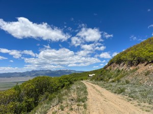
The trip down was sunny and much different than the trip up. The hill was very long and very steep. It was wide, which meant even though it was loose it wasn't too intimidating.

The western side of the Sangre de Cristo mountains is very sloped, so it takes awhile to come down to the valley floor though you can see your trail for at least a mile, stretching out in front of you. It was beautiful as we came down to the floor and aired up at a turnout on the side of the road.

It was a great start to a great weekend as we headed off to Alamosa with plenty of time to check into hotels and get to dinner and a relaxing evening of playing pool. Ladd met us later and we got ourselves mentally prepared for Blanca Peak in the morning.

above_the_clouds
airing_down_part_1
airing_down_part_2
airing_down_part_3
big_view
blue_sky
bob_r_at_the_pass
bob_r_at_the_top
bob_s_and_monica
bob_s_at_the_pass
bob_s_on_the_trail
bumpy
colors
down_the_steep_hill
early_dirt_road
first_climb
forest
great_sand_dunes_and_blanca_peak
hayden_pass
hiking_trail
into_the_clouds
jeeps_at_the_top
low_clouds
misty
monica_at_the_pass
narrow_trail
parked
pavement_start
pose
puffy
rocky
sangre_de_cristo_mountains
shelf_road
sign_at_the_top
steep_hill
thinning_trees
trail_of_rocks
trailhead
trees_and_clouds
valley
view_of_the_other_side
Join Us!
If you aren’t a Member or Subscriber, you can’t see all of the content on this site. Get membership information to see why this site is best when you join and log in

Information for Subscribers

When you log in you’ll see more information here:

  • Recent Community Forum posts
  • Recent polls
  • Upcoming Events you can attend
  • Links to online users

© 2000-2019 · TrailDamage.com · Terms and Conditions · About · Contact
Trail information is only accurate on the date posted. Trails may have changed or closed since that date. Use this information for historical purposes only.
Contact the Forest Service or Bureau of Land Management for up-to-date trail information.

/* ----------------------------------------- */ /* View slug: reports-other-reports-for-same-trail-slider - start */ /* ----------------------------------------- */ /* place the prev/next controls on the sides */ .td-transition-controls .wpv-filter-next-link, .td-transition-controls .wpv-filter-previous-link { border: none; font-size: 300%; position: absolute; top: 70px; } .td-transition-controls .wpv-filter-previous-link { left: 0; } .td-transition-controls .wpv-filter-next-link { right: 0; } /* center the page selector horizonatally */ .td-transition-controls ul.wpv_pagination_dots { text-align: center; margin-top: 10px; } /* center the page selector horizonatally */ .td-transition-controls ul.wpv_pagination_dots li.wpv_pagination_dots_item, .td-transition-controls .wpv_pagination_dots li a { display: inline-block; float: none; } /* remove the default styles */ .td-transition-controls .wpv_pagination_dots li a { text-decoration: none; border-bottom: none; } .td-slider-container { padding: 0 25px; margin-bottom: 20px; position: relative; width:100%; display:table; } .td-slides { position: relative; } .td-slides-image { float:left; display:table-cell; } .td-slides-image img { border:1px solid #c0c0c0; } .td-slides-content { padding:4px 4px 4px 10px; border-top:1px solid #c0c0c0; border-right:1px solid #c0c0c0; border-bottom:1px solid #c0c0c0; display:table-cell; height:227px; overflow:hidden; } .td-slides-content h3 { margin-top:8px; } .td-slides-leader { font-size:smaller; margin-top:4px; } /* ----------------------------------------- */ /* View slug: reports-other-reports-for-same-trail-slider - end */ /* ----------------------------------------- */
/* ----------------------------------------- */ /* Content Template: Template for a Single Report - start */ /* ----------------------------------------- */ .entry-header { display:none; } .entry-content h1 { margin-top:16px; padding-top:0; } h1 a { color:#222; } h1 a:hover { color:#666; } p.entry-meta { font-size:small; } #report-body-spacer { clear:both; width:100%; height:20px; } #addtoany-bar { margin-bottom:2em; text-align:center; } .category-reports .post-info .author, .post-info .date { display: none; } .addthis_recommended_horizontal { text-align:center !important; } /* ----------------------------------------- */ /* Content Template: Template for a Single Report - end */ /* ----------------------------------------- */ /* ----------------------------------------- */ /* Content Template: Loop item in REPORTS Runners - start */ /* ----------------------------------------- */ #runners-container { width:100%; clear:both; } .runner { border:1px solid #c0c0c0; margin:0 6px 6px 0; float:left; width:49%; height:81px; } .runner-image { float: left; } .runner-image img { margin:2px 10px 0 2px; height:75px; width:75px; } .runner-name { text-transform:uppercase; } .runner-name a { color:#222; } .runner-name a:hover { color:#666; } .runner-vehicle { font-size:small; } @media only screen and (max-width: 768px) { .runner { width:100%; } } /* ----------------------------------------- */ /* Content Template: Loop item in REPORTS Runners - end */ /* ----------------------------------------- */