TrailDamage.com

Photos, videos and information about 4x4 trails in Colorado and Utah

  • Trails
    • Colorado
    • Utah
  • Reports
    • Featured Photos
    • Featured Videos
    • Reports Calendar
  • Members
  • Search
  • Trail Damage Winners
  • FAQ
  • Community
  • Upcoming Events
  • Membership
  • Log In
  • Facebook
  • Instagram
  • RSS
  • Twitter
  • YouTube

Hahns Peak 120831

August 31, 2012 by Monica

Hahns Peak

Trail Run on August 31, 2012
Report and photos by Monica I., Trail Leader
View trail information for Hahns Peak

Mike S.
Silver 2004 Jeep Wrangler Rubicon
Monica I.
Red 2010 Jeep Wrangler Rubicon
Walt S.
Gray 2022 Jeep Wrangler Unlimited Rubicon 392
Roger R.
Gray 2021 Jeep Wrangler Rubicon 4xe

Monica, Mike, and Walt had been on the Hahns Peak trail back in 2006, but it was covered in snow during that time. We didn't get a chance to go to the top of Hahns Peak during that trip because the snow stopped us, so we were motivated to get to the high point this time. We came off of the Farwell Mountain trail and headed for Hahns Peak.

We had hoped to find the time to do many more of the trails that spur off of Hahns Peak, but we had to pass by them this time. It was a bummer to keep driving by new trails. There's always a "next time" so we just had to wait for that.

We had stopped by the forest service office in Steamboat Springs on the way to our cabins on Seedhouse Road, and they told us there was no sinkhole on the trail. That section was open, they said. So we weren't worried about it. When we got there, we found the sinkhole filled with rocks and logs, but not completely repaired. It seemed like something worth mentioning, though, and we were a little surprised. We would try to remember to call them and wish them a "happy sinkhole denial" on May 5th next year.

We took our time going over the sinkhole but it ended up not being a big deal. It was really filled in well, and our Jeeps are not very wide. A wider truck might have issues, though, and it could really derail a dirtbike if the rider wasn't paying close attention.

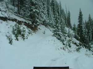
Just up from the sinkhole was the spur up Hahns Peak. Walt remembered driving much higher up the mountain, so he must have gone up the other spur while it was open to the public. The spur that went around the north side of the mountain to the Royal Flush Mine was private property now, leaving only the spur that took us halfway up.

There was enough room for our four Jeeps and our seats for a dinner break. It was a new twist, eating lunch at a restaurant and dinner on the trail. It was a nice change of pace. We sat on the edge and enjoyed the views below us as we had a nice dinner on the trail.

After dinner we headed down and did some wandering around to catch the rest of the trail. It was nice in the trees though it wasn't as scenic. Still, it's a nice trail that covers a lot of area, and we enjoyed seeing it not covered in snow.

approaching_hahns_peak
big_view
bumpy
dinner_part_1
dinner_part_2
dinner_part_3
little_bumps
mike_over_the_sinkhole_part_1
mike_over_the_sinkhole_part_2
monica_over_the_sinkhole_part_1
monica_over_the_sinkhole_part_2
mountain_views
panorama_1
panorama_2
roger_over_the_sinkhole_part_1
roger_over_the_sinkhole_part_2
sinkhole_part_1
sinkhole_part_2
sun_at_the_top
sun_through_clouds
top_of_the_trail
unknown_thing
walt_over_the_sinkhole_part_1
walt_over_the_sinkhole_part_2

Report from a Different Day

September 24, 2006

Led by Monica I.
Hahns Peak was going to be the first trail of our last day in the Steamboat Springs area. We were hoping that there wouldn’t be too much snow for our climb over the side of Hahns Peak, or at least not so much snow that we’d have to turn back….
Join Us!
If you aren’t a Member or Subscriber, you can’t see all of the content on this site. Get membership information to see why this site is best when you join and log in

Information for Subscribers

When you log in you’ll see more information here:

  • Recent Community Forum posts
  • Recent polls
  • Upcoming Events you can attend
  • Links to online users

© 2000-2022 · TrailDamage.com · Terms and Conditions · About · Contact
Trail information is only accurate on the date posted. Trails may have changed or closed since that date. Use this information for historical purposes only.
Contact the Forest Service or Bureau of Land Management for up-to-date trail information.

/* ----------------------------------------- */ /* View slug: reports-other-reports-for-same-trail-slider - start */ /* ----------------------------------------- */ /* place the prev/next controls on the sides */ .td-transition-controls .wpv-filter-next-link, .td-transition-controls .wpv-filter-previous-link { border: none; font-size: 300%; position: absolute; top: 70px; } .td-transition-controls .wpv-filter-previous-link { left: 0; } .td-transition-controls .wpv-filter-next-link { right: 0; } /* center the page selector horizonatally */ .td-transition-controls ul.wpv_pagination_dots { text-align: center; margin-top: 10px; } /* center the page selector horizonatally */ .td-transition-controls ul.wpv_pagination_dots li.wpv_pagination_dots_item, .td-transition-controls .wpv_pagination_dots li a { display: inline-block; float: none; } /* remove the default styles */ .td-transition-controls .wpv_pagination_dots li a { text-decoration: none; border-bottom: none; } .td-slider-container { padding: 0 25px; margin-bottom: 20px; position: relative; width:100%; display:table; } .td-slides { position: relative; } .td-slides-image { float:left; display:table-cell; } .td-slides-image img { border:1px solid #c0c0c0; } .td-slides-content { padding:4px 4px 4px 10px; border-top:1px solid #c0c0c0; border-right:1px solid #c0c0c0; border-bottom:1px solid #c0c0c0; display:table-cell; height:227px; overflow:hidden; } .td-slides-content h3 { margin-top:8px; } .td-slides-leader { font-size:smaller; margin-top:4px; } /* ----------------------------------------- */ /* View slug: reports-other-reports-for-same-trail-slider - end */ /* ----------------------------------------- */
/* ----------------------------------------- */ /* Content Template: Template for a Single Report - start */ /* ----------------------------------------- */ .entry-header { display:none; } .entry-content h1 { margin-top:16px; padding-top:0; } h1 a { color:#222; } h1 a:hover { color:#666; } p.entry-meta { font-size:small; } #report-body-spacer { clear:both; width:100%; height:20px; } #addtoany-bar { margin-bottom:2em; text-align:center; } .category-reports .post-info .author, .post-info .date { display: none; } .addthis_recommended_horizontal { text-align:center !important; } /* ----------------------------------------- */ /* Content Template: Template for a Single Report - end */ /* ----------------------------------------- */ /* ----------------------------------------- */ /* Content Template: Loop item in REPORTS Runners - start */ /* ----------------------------------------- */ #runners-container { width:100%; clear:both; } .runner { border:1px solid #c0c0c0; margin:0 6px 6px 0; float:left; width:49%; height:81px; } .runner-image { float: left; } .runner-image img { margin:2px 10px 0 2px; height:75px; width:75px; } .runner-name { text-transform:uppercase; } .runner-name a { color:#222; } .runner-name a:hover { color:#666; } .runner-vehicle { font-size:small; } @media only screen and (max-width: 768px) { .runner { width:100%; } } /* ----------------------------------------- */ /* Content Template: Loop item in REPORTS Runners - end */ /* ----------------------------------------- */