TrailDamage.com

Photos, videos and information about 4x4 trails in Colorado and Utah

  • Trails
    • Colorado
    • Utah
  • Reports
    • Featured Photos
    • Featured Videos
    • Reports Calendar
  • Members
  • Search
  • Trail Damage Winners
  • FAQ
  • Community
  • Upcoming Events
  • Membership
  • Log In
  • Facebook
  • Instagram
  • RSS
  • Twitter
  • YouTube

Hahns Peak 060924

September 24, 2006 by Monica

Hahns Peak

Trail Run on September 24, 2006
Report and photos by Monica I., Trail Leader
View trail information for Hahns Peak

Walt S.
Gray 2022 Jeep Wrangler Unlimited Rubicon 392
Mike S.
Silver 2004 Jeep Wrangler Rubicon
Monica I.
Red 2010 Jeep Wrangler Rubicon

Hahns Peak was going to be the first trail of our last day in the Steamboat Springs area. We were hoping that there wouldn't be too much snow for our climb over the side of Hahns Peak, or at least not so much snow that we'd have to turn back. We had a great breakfast at the Steamboat Lake Outfitters (SLO) before heading out to the trail just a few miles north.

We got a good start and right away we were having to verify that we were on the right road seemingly every few hundred yards. There were lots of spur roads, and many of them weren't marked. We only chose one wrong road, though, and luckily that ended at a gate right away. We just kept picking the spur that went uphill and we did fine.

The climb up was pretty snowy but we did okay. We got to the first wide spot on the climb, discussed it, and decided to keep going. Some of the sections were near the cliff's edge but we felt pretty safe. The snow wasn't too icy or deep.

We made it all the way to the top and found the final spur that got the closest to the top. It was really steep and narrow, and we knew it would be really stupid to even try it. We kept going.

We worked our way down and to the next wide, flat spot. Then someone showed up and asked if we had a shovel. Some people were out in a late model Suburban on street tires, and they were in trouble.

They borrowed a couple shovels and some of them started digging down to the dirt in a long strip. The driver brought the Suburban down to where we were so he could get turned around so they could get back out.

It took Mike and his winch a lot of time to get the Suburban turned around. It was just too slick for its tires, and the driver was new. He finally got turned around and we wished him luck. Mike went up to the flat spot at the top ahead of them, just in case they needed winching.

It didn't start out too well, but then someone else got behind the wheel and the Suburban powered its way to the top. Mike watched them go down the other side, then returned to us. We continued on.

The last downhill bit had really deep snow (maybe a foot or a bit more) and it was very packed. It made the descent a little bit better, and soon we were in the open area. We were surprised to find bare trail here.

We worked our way back into the trees and found more snow as we went over part of Twin Mountain. The descent was snowy but we took our time and it went just fine. Luckily the snow was melted in some of the places where it would have been pretty bad otherwise.

We were considering doing the Farwell Mountain spur, but then when we got there we thought the better of it and skipped it. It was just too snowy to be up there.

We checked out the Farwell Mine (a trough and a hose, basically) and continued on. The mud in the meadow was really slick, and we all worked our way through it, sliding all over the place. No one got stuck or anything, though, and it was pretty fun.

We had a nice lunch at the top of the last muddy hill. The sun was out and we were enjoying some blue sky for the first time since leaving Denver. Some ATVs went by, but other than that we didn't see anyone else. We also saw horse tracks in the mud but didn't see the horses.

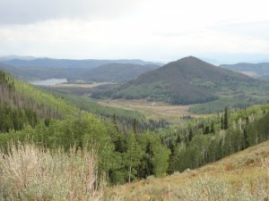
We passed through the forest service gate and continued on until we were in town. The views were spectacular and we were a little sad to leave. We went down the road a bit to check out Seedhouse Road on our way home. It was a great day of all different weather.

airing_down
around_a_bend
aspen_colors
aspens
big_mud_puddle
big_puddle
bumpy
climb_to_hahns_peak_on_the_left
climbing
close_trees
colorado_colors
crown_of_aspens
curve
curving_road
dirt_trail
early_trail
farwell_mine_part_1
farwell_mine_part_2
first_crossroads
forest_service_gate
georgina_walking
greens
hahns_peak_descent
hahns_peak_part_1
hahns_peak_part_2
hahns_peak_part_3
hahns_peak_part_4
hahns_peak_part_5
hahns_peak_part_6
hahns_peak_part_7
hahns_peak_part_8
icicles
looks_like_fall
lunch_view
lunch
mike_at_lunch
mike_on_the_trail
mike_up_a_muddy_hill
monica_at_lunch
monica_muddy_tire
monica_tonneau_collection
mountain_range
mountain_view
mud_bog_part_1
mud_bog_part_2
mud_bog_part_3
mud_bog_part_4
on_the_trail
open_area
puddle
quiet
really_muddy
road_improvements
road_not_really_closed
rocky_climb
sign_at_forest_service_gate
signs_next_to_climb_to_hahns_peak
sloppy
slow_descent
snow_melting
snowier
snowy_descent
sparse_aspens
start_of_the_trail
steamboat_lake_outfitters
steamboat_lake
straight_trail
suburban_part_1
suburban_part_2
suburban_part_3
suburban_part_4
suburban_part_5
sunshine_coming
sunshine
trail_ahead
trees_above
trees_in_close
trench
valley_view
walt_and_mike_in_mud
walt_at_lunch
walt_on_the_trail
walt_up_a_muddy_hill
winter

Report from a Different Day

August 31, 2012

Led by Monica I.
Monica, Mike, and Walt had been on the Hahns Peak trail back in 2006, but it was covered in snow during that time. We didn’t get a chance to go to the top of Hahns Peak during that trip because the snow stopped us, so we were motivated to get…
Join Us!
If you aren’t a Member or Subscriber, you can’t see all of the content on this site. Get membership information to see why this site is best when you join and log in

Information for Subscribers

When you log in you’ll see more information here:

  • Recent Community Forum posts
  • Recent polls
  • Upcoming Events you can attend
  • Links to online users

© 2000-2022 · TrailDamage.com · Terms and Conditions · About · Contact
Trail information is only accurate on the date posted. Trails may have changed or closed since that date. Use this information for historical purposes only.
Contact the Forest Service or Bureau of Land Management for up-to-date trail information.

/* ----------------------------------------- */ /* View slug: reports-other-reports-for-same-trail-slider - start */ /* ----------------------------------------- */ /* place the prev/next controls on the sides */ .td-transition-controls .wpv-filter-next-link, .td-transition-controls .wpv-filter-previous-link { border: none; font-size: 300%; position: absolute; top: 70px; } .td-transition-controls .wpv-filter-previous-link { left: 0; } .td-transition-controls .wpv-filter-next-link { right: 0; } /* center the page selector horizonatally */ .td-transition-controls ul.wpv_pagination_dots { text-align: center; margin-top: 10px; } /* center the page selector horizonatally */ .td-transition-controls ul.wpv_pagination_dots li.wpv_pagination_dots_item, .td-transition-controls .wpv_pagination_dots li a { display: inline-block; float: none; } /* remove the default styles */ .td-transition-controls .wpv_pagination_dots li a { text-decoration: none; border-bottom: none; } .td-slider-container { padding: 0 25px; margin-bottom: 20px; position: relative; width:100%; display:table; } .td-slides { position: relative; } .td-slides-image { float:left; display:table-cell; } .td-slides-image img { border:1px solid #c0c0c0; } .td-slides-content { padding:4px 4px 4px 10px; border-top:1px solid #c0c0c0; border-right:1px solid #c0c0c0; border-bottom:1px solid #c0c0c0; display:table-cell; height:227px; overflow:hidden; } .td-slides-content h3 { margin-top:8px; } .td-slides-leader { font-size:smaller; margin-top:4px; } /* ----------------------------------------- */ /* View slug: reports-other-reports-for-same-trail-slider - end */ /* ----------------------------------------- */
/* ----------------------------------------- */ /* Content Template: Template for a Single Report - start */ /* ----------------------------------------- */ .entry-header { display:none; } .entry-content h1 { margin-top:16px; padding-top:0; } h1 a { color:#222; } h1 a:hover { color:#666; } p.entry-meta { font-size:small; } #report-body-spacer { clear:both; width:100%; height:20px; } #addtoany-bar { margin-bottom:2em; text-align:center; } .category-reports .post-info .author, .post-info .date { display: none; } .addthis_recommended_horizontal { text-align:center !important; } /* ----------------------------------------- */ /* Content Template: Template for a Single Report - end */ /* ----------------------------------------- */ /* ----------------------------------------- */ /* Content Template: Loop item in REPORTS Runners - start */ /* ----------------------------------------- */ #runners-container { width:100%; clear:both; } .runner { border:1px solid #c0c0c0; margin:0 6px 6px 0; float:left; width:49%; height:81px; } .runner-image { float: left; } .runner-image img { margin:2px 10px 0 2px; height:75px; width:75px; } .runner-name { text-transform:uppercase; } .runner-name a { color:#222; } .runner-name a:hover { color:#666; } .runner-vehicle { font-size:small; } @media only screen and (max-width: 768px) { .runner { width:100%; } } /* ----------------------------------------- */ /* Content Template: Loop item in REPORTS Runners - end */ /* ----------------------------------------- */