TrailDamage.com

Photos, videos and information about 4x4 trails in Colorado and Utah

  • Trails
    • Colorado
    • Utah
  • Reports
    • Featured Photos
    • Featured Videos
    • Reports Calendar
  • Members
  • Search
  • Trail Damage Winners
  • FAQ
  • Community
  • Upcoming Events
  • Membership
  • Log In
  • Facebook
  • Instagram
  • RSS
  • Twitter
  • YouTube

Green Ridge 081004

October 4, 2008 by Monica

Green Ridge

Trail Run on October 4, 2008
Report and photos by Monica I., Trail Leader
View trail information for Green Ridge

Don W.
Silver 2005 Jeep Wrangler Rubicon
Bill S.
Yellow 2020 Jeep Wrangler Rubicon
Mike S.
Silver 2004 Jeep Wrangler Rubicon

We'd been trying to do Green Ridge for a few years, but weather kept getting in the way. In fact, we already had it scheduled as a spring run but the trail didn't open in time due to a particularly snowy winter. We rescheduled it, and we were finally going to see it.

Unfortunately, the weather wasn't going to cooperate. It was fairly overcast, and it would stay that way all day. We wouldn't see the sun, and it would start drizzling just after lunch. Still, the extra water kept things muddy.

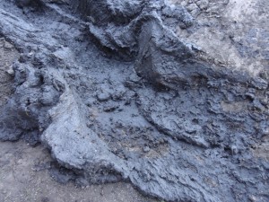
There were lots of mud puddles, and we could definitely see how it would get a little crazy in the spring. You could see how the mud once made it all the way to the edges in places, but for us it was usually just in the middle of the trail.

We were sad to see that ATVs had made so many illegal bypasses around the muddy sections. There were well-used trails through the trees at every puddle, between trees far too close together for even a small 4x4 vehicle to fit through. Why do a trail like Green Ridge if you want to avoid the mud? It doesn't make sense.

Though there was a lot of mud, it never stopped us. We were there during the time of year when it was the least muddy, and it just made things messy. It would be a blast if you wanted to get your rig covered in mud.

It was also pretty rocky in most places. Some rocks were challenging with slick tires, too. That was a nice surprise.

The sad part was the scenery. We stayed in the trees the entire time, with one fleeting glimpse of mountains. The trail opened up into a couple of big meadows at the north end, but otherwise it was all pine trees with a small handful of aspen trees here and there.

We followed the signs provided for snowmobilers, pointing us left and right around trees in the trail. Route finding was very easy.

When we got to the intersection with 319 we took it, continuing north. We turned into the network of trails north of the Bald Mountain trail, doing some exploring. Then we decided we wanted to see all of Green Ridge so we did the north section when we came to the wooden sign on Bald Mountain. After seeing the end of Green Ridge, we took 319 yet again to the end of Bald Mountain. It took some time to do the exploring, but everyone was content.

Green Ridge was a good time, and we'll definitely head back that way to check it out in the spring. It would be a blast with a lot of mud!

airing_down
aspen_leaves
bumpy_trail
cabin
climb
fall_colors
first_water_crossing
follow_arrows
forest_service_sign
former_long_trench
fun_climb
intersection_with_319
intersection_with_bald_mountain_part_1
intersection_with_bald_mountain_part_2
lost_lake_part_1
lost_lake_part_2
meadow
mountain_view
muddy_1
muddy_2
muddy_3
muddy_4
muddy_5
muddy_6
muddy_7
muddy_8
muddy_9
nice_view
optional_mud
rocky
seasonal_gate
start_of_the_trail
trailhead_sign_1
trailhead_sign_2
trailhead_sign_3
trailhead

Report from a Different Day

September 12, 2015

Led by Monica I.
Mud on Green Ridge? No way! It was September, and we weren’t too far into the northern end of the trail before we found a nice, big mud puddle. It was tough to say for sure, but we guessed we were in for a muddy trip back to the highway….
Join Us!
If you aren’t a Member or Subscriber, you can’t see all of the content on this site. Get membership information to see why this site is best when you join and log in

Information for Subscribers

When you log in you’ll see more information here:

  • Recent Community Forum posts
  • Recent polls
  • Upcoming Events you can attend
  • Links to online users

© 2000-2023 · TrailDamage.com · Terms and Conditions · About · Contact
Trail information is only accurate on the date posted. Trails may have changed or closed since that date. Use this information for historical purposes only.
Contact the Forest Service or Bureau of Land Management for up-to-date trail information.

/* ----------------------------------------- */ /* View slug: reports-other-reports-for-same-trail-slider - start */ /* ----------------------------------------- */ /* place the prev/next controls on the sides */ .td-transition-controls .wpv-filter-next-link, .td-transition-controls .wpv-filter-previous-link { border: none; font-size: 300%; position: absolute; top: 70px; } .td-transition-controls .wpv-filter-previous-link { left: 0; } .td-transition-controls .wpv-filter-next-link { right: 0; } /* center the page selector horizonatally */ .td-transition-controls ul.wpv_pagination_dots { text-align: center; margin-top: 10px; } /* center the page selector horizonatally */ .td-transition-controls ul.wpv_pagination_dots li.wpv_pagination_dots_item, .td-transition-controls .wpv_pagination_dots li a { display: inline-block; float: none; } /* remove the default styles */ .td-transition-controls .wpv_pagination_dots li a { text-decoration: none; border-bottom: none; } .td-slider-container { padding: 0 25px; margin-bottom: 20px; position: relative; width:100%; display:table; } .td-slides { position: relative; } .td-slides-image { float:left; display:table-cell; } .td-slides-image img { border:1px solid #c0c0c0; } .td-slides-content { padding:4px 4px 4px 10px; border-top:1px solid #c0c0c0; border-right:1px solid #c0c0c0; border-bottom:1px solid #c0c0c0; display:table-cell; height:227px; overflow:hidden; } .td-slides-content h3 { margin-top:8px; } .td-slides-leader { font-size:smaller; margin-top:4px; } /* ----------------------------------------- */ /* View slug: reports-other-reports-for-same-trail-slider - end */ /* ----------------------------------------- */
/* ----------------------------------------- */ /* Content Template: Template for a Single Report - start */ /* ----------------------------------------- */ .entry-header { display:none; } .entry-content h1 { margin-top:16px; padding-top:0; } h1 a { color:#222; } h1 a:hover { color:#666; } p.entry-meta { font-size:small; } #report-body-spacer { clear:both; width:100%; height:20px; } #addtoany-bar { margin-bottom:2em; text-align:center; } .category-reports .post-info .author, .post-info .date { display: none; } .addthis_recommended_horizontal { text-align:center !important; } /* ----------------------------------------- */ /* Content Template: Template for a Single Report - end */ /* ----------------------------------------- */ /* ----------------------------------------- */ /* Content Template: Loop item in REPORTS Runners - start */ /* ----------------------------------------- */ #runners-container { width:100%; clear:both; } .runner { border:1px solid #c0c0c0; margin:0 6px 6px 0; float:left; width:49%; height:81px; } .runner-image { float: left; } .runner-image img { margin:2px 10px 0 2px; height:75px; width:75px; } .runner-name { text-transform:uppercase; } .runner-name a { color:#222; } .runner-name a:hover { color:#666; } .runner-vehicle { font-size:small; } @media only screen and (max-width: 768px) { .runner { width:100%; } } /* ----------------------------------------- */ /* Content Template: Loop item in REPORTS Runners - end */ /* ----------------------------------------- */