TrailDamage.com

Photos, videos and information about 4x4 trails in Colorado and Utah

  • Trails
    • Colorado
    • Utah
  • Reports
    • Featured Photos
    • Featured Videos
    • Reports Calendar
  • Members
  • Search
  • Trail Damage Winners
  • FAQ
  • Community
  • Upcoming Events
  • Membership
  • Log In
  • Facebook
  • Instagram
  • RSS
  • Twitter
  • YouTube

Geneva Creek 160924

September 24, 2016 by Monica

Geneva Creek

Trail Run on September 24, 2016
Report and photos by Monica I., Trail Leader
View trail information for Geneva Creek

Joe C.
Silver 2012 Jeep Wrangler Unlimited Rubicon
Monica I.
Red 2010 Jeep Wrangler Rubicon
Mike S.
Silver 2004 Jeep Wrangler Rubicon
Matt K.
White 2016 Jeep Wrangler Unlimited Rubicon
Eric S.
Yellow 2004 Nissan Xterra

The official TrailDamage.com camera finally kicked the bucket after being filled with dirt and sand for years. We asked our followers for donations and they responded right away, funding a new camera for the group. We did what we could to repay the favor, sponsoring them with membership. Joe joined the group first, and we took some great photos with the new camera. We met in Bailey for a change of pace and then headed off to Geneva Creek.

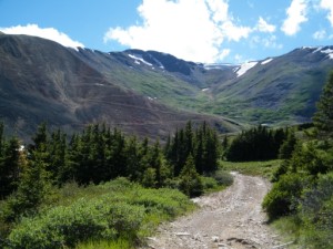
It was the big weekend for changing aspens in Colorado, and the trees had leaves that changed from green to yellow. It's a narrow window of time as the wind soon blows the yellow leaves to the ground. That meant that everyone left Denver and headed for the hills, and Guanella Pass is a popular spot to take pictures of the leaves. We had to do a bit of Guanella Pass to get to Geneva Creek, and it was a parade of cars and people wandering all over the place. Still, everyone was smiling and it was a happy experience.

When we got to our little patch of dirt around a few trees where we used to air up and down at the trailhead we were surprised to find it paved with parking spaces, a kiosk, and a sign for Duck Creek. It was really weird but pretty nice. It promised to be a chilly day while we got ready for trails.

People were waking up from a cold night of camping, with snow on the sides of their tents. Not many campers looked like they were prepared for the night, wearing thin pajamas and pained expressions. We hoped they got their fires started soon to warm up.

As we climbed, there was more snow at the sides of the trail. It kept getting colder, too. We crossed our fingers and hoped we wouldn't run into anyone on their way down as passing is so difficult. We did find someone, but it was right at one of the few wide spots so it worked out just fine.

We climbed up without incident and stopped at the big cabin ruins at the "Y" intersection. It was definitely cold and windy, and the boys had a snowball fight with the small amount of snow in spots. We looked up at the basin between the mountains and decided to head up there first. It looked very chilly.

The climb up to the top had some snow on it but it wasn't slick yet. When we got to the top it was very windy and very cold. But it was the first exposure to the 2016-2017 winter and we enjoyed it in a weird way. Everyone took lots of pictures, and Matt's Exchange Student hiked up the side of Revenue Mountain for a ways to check out the views and take a picture of us from high above. Even though the weather was wintery, we stayed for a while before heading down.

We could see Santa Fe Peak was in the middle of a snow storm, but we headed over there anyway. Luckily, it wasn't a blizzard when we got there. The scenery was gorgeous, and we took lots of pictures as we explored the old mining site. It was windy, though, and we decided to have lunch there in our vehicles. It takes a lot to drive us to that.

We stayed for a while but then headed back down. We saw other vehicles on their way up the big hill, but we got lucky again and passed them in wide spots. Many of the campers we saw earlier were gone when we passed that area again, hopefully to go warm up in town.

The trail was fabulous and scenic, as always, and we had a great time. There was still a lot of daylight left, though, so we headed over to Slaughterhouse Gulch.

airing_down
aspens
at_the_top
autumn_colors
bare_aspens
basin
bumpy_trail
checking_things_out
chilly_night_camping
climbing
clouds_clearing
colorful
creek_near_the_source
duck_creek_parking
duck_creek_sign
early_trail
eric_and_mike_near_the_mine
eric_and_mike
eric_at_the_top
eric_earlier_damage
eric_in_scenery
eric_parked
eric_to_the_top_part_1
eric_to_the_top_part_2
exploring
fence
geneva_creek_part_1
geneva_creek_part_2
geneva_creek_part_3
geneva_creek_part_4
go_slow
grasses
green_valley
guanella_pass
hardy
heading_down
healthy_pines
history
ice_sheet
iron_fens_gate
iron_fens_sign
joe_at_the_edge
joe_at_the_top
joe_heading_down
joe_in_scenery
joe_near_the_mine
joe_on_the_trail
joe_parked_part_1
joe_parked_part_2
joe_to_the_top_part_1
joe_to_the_top_part_2
kiosk_part_1
kiosk_part_2
kiosk_part_3
kiosk_part_4
kiosk_part_5
layers
less_snow
looks_chilly
lunch
matt_at_the_bucksnort_saloon
matt_heading_down
matt_parked
matt_to_the_top_part_1
matt_to_the_top_part_2
meeting_in_bailey
mike_at_the_top
mike_ditching_windows
mike_flexing
mike_in_scenery
mike_parked
mike_to_the_top_part_1
mike_to_the_top_part_2
mike_to_the_top_part_3
monica_at_the_top
monica_in_aspens
monica_in_the_sun
monica_on_the_trail
monica_parked
monica_taking_pictures
monica_through_the_creek
monica_uphill
nyree_at_the_top
nyree_in_aspens
old_building
old_structure
patch_of_blue
private_cabin
puddle_and_hill
ridge
rocky_climb
rocky
santa_fe_peak
shelf_road
silver_mountain
snow_at_the_cabin
snowing_on_santa_fe_peak
snowy_ahead
snowy_hill
source
start_of_the_trail
steep_climb
to_the_mine
up_the_basin
valley_view
view_from_above
view_from_the_top
water_crossing
wavy
white_sky
winter_is_coming
yellow_and_green

Reports from Other Days: 2

Use the arrows or dots to flip through the previews of the other reports for Geneva Creek. Click one of them to read more and see all of the photos from that day.

July 10, 2010

Led by Monica I.
We finished Slaughterhouse Gulch in record time, so we had plans to continue exploring. We had hoped to find a trail that circled Derringer Peak, but when we went around to the trailhead it turned out to be private property. We wandered around a little bit, but all of our…
»
  • 1
  • 2
Join Us!
If you aren’t a Member or Subscriber, you can’t see all of the content on this site. Get membership information to see why this site is best when you join and log in

Information for Subscribers

When you log in you’ll see more information here:

  • Recent Community Forum posts
  • Recent polls
  • Upcoming Events you can attend
  • Links to online users

© 2000-2023 · TrailDamage.com · Terms and Conditions · About · Contact
Trail information is only accurate on the date posted. Trails may have changed or closed since that date. Use this information for historical purposes only.
Contact the Forest Service or Bureau of Land Management for up-to-date trail information.

/* ----------------------------------------- */ /* View slug: reports-other-reports-for-same-trail-slider - start */ /* ----------------------------------------- */ /* place the prev/next controls on the sides */ .td-transition-controls .wpv-filter-next-link, .td-transition-controls .wpv-filter-previous-link { border: none; font-size: 300%; position: absolute; top: 70px; } .td-transition-controls .wpv-filter-previous-link { left: 0; } .td-transition-controls .wpv-filter-next-link { right: 0; } /* center the page selector horizonatally */ .td-transition-controls ul.wpv_pagination_dots { text-align: center; margin-top: 10px; } /* center the page selector horizonatally */ .td-transition-controls ul.wpv_pagination_dots li.wpv_pagination_dots_item, .td-transition-controls .wpv_pagination_dots li a { display: inline-block; float: none; } /* remove the default styles */ .td-transition-controls .wpv_pagination_dots li a { text-decoration: none; border-bottom: none; } .td-slider-container { padding: 0 25px; margin-bottom: 20px; position: relative; width:100%; display:table; } .td-slides { position: relative; } .td-slides-image { float:left; display:table-cell; } .td-slides-image img { border:1px solid #c0c0c0; } .td-slides-content { padding:4px 4px 4px 10px; border-top:1px solid #c0c0c0; border-right:1px solid #c0c0c0; border-bottom:1px solid #c0c0c0; display:table-cell; height:227px; overflow:hidden; } .td-slides-content h3 { margin-top:8px; } .td-slides-leader { font-size:smaller; margin-top:4px; } /* ----------------------------------------- */ /* View slug: reports-other-reports-for-same-trail-slider - end */ /* ----------------------------------------- */
/* ----------------------------------------- */ /* Content Template: Template for a Single Report - start */ /* ----------------------------------------- */ .entry-header { display:none; } .entry-content h1 { margin-top:16px; padding-top:0; } h1 a { color:#222; } h1 a:hover { color:#666; } p.entry-meta { font-size:small; } #report-body-spacer { clear:both; width:100%; height:20px; } #addtoany-bar { margin-bottom:2em; text-align:center; } .category-reports .post-info .author, .post-info .date { display: none; } .addthis_recommended_horizontal { text-align:center !important; } /* ----------------------------------------- */ /* Content Template: Template for a Single Report - end */ /* ----------------------------------------- */ /* ----------------------------------------- */ /* Content Template: Loop item in REPORTS Runners - start */ /* ----------------------------------------- */ #runners-container { width:100%; clear:both; } .runner { border:1px solid #c0c0c0; margin:0 6px 6px 0; float:left; width:49%; height:81px; } .runner-image { float: left; } .runner-image img { margin:2px 10px 0 2px; height:75px; width:75px; } .runner-name { text-transform:uppercase; } .runner-name a { color:#222; } .runner-name a:hover { color:#666; } .runner-vehicle { font-size:small; } @media only screen and (max-width: 768px) { .runner { width:100%; } } /* ----------------------------------------- */ /* Content Template: Loop item in REPORTS Runners - end */ /* ----------------------------------------- */