TrailDamage.com

Photos, videos and information about 4x4 trails in Colorado and Utah

  • Trails
    • Colorado
    • Utah
  • Reports
    • Featured Photos
    • Featured Videos
    • Reports Calendar
  • Members
  • Search
  • Trail Damage Winners
  • FAQ
  • Community
  • Upcoming Events
  • Membership
  • Log In
  • Facebook
  • Instagram
  • RSS
  • Twitter
  • YouTube

Geneva Creek 100710

July 10, 2010 by Monica

Geneva Creek

Trail Run on July 10, 2010
Report and photos by Monica I., Trail Leader
View trail information for Geneva Creek

Matt K.
White 2016 Jeep Wrangler Unlimited Rubicon
Walt S.
Gray 2022 Jeep Wrangler Unlimited Rubicon 392
Monica I.
Red 2010 Jeep Wrangler Rubicon

We finished Slaughterhouse Gulch in record time, so we had plans to continue exploring. We had hoped to find a trail that circled Derringer Peak, but when we went around to the trailhead it turned out to be private property. We wandered around a little bit, but all of our options didn't pan out. In the end, we decided to check out Geneva Creek because it wasn't too far up the highway from Slaughterhouse Gulch.

Just like last time, it was packed with people camping in just about every available space. That meant for lots of traffic on the road. We waved at everyone as we worked our way to the intersection where we hoped to leave most of the crowd behind.

The rain clouds were threatening as we climbed up the narrow trail. We were about halfway to the top when we came to a large truck headed down in the other direction. It started to rain as we tried to figure out a way to pass each other.

It became clear that the driver of the truck was in over his head as he refused to get out of the truck and he refused to back up. We had figured out a way for all of us to get by each other, but he refused to do anything other than continue forward. Fear can make anyone act strangely, especially if you have your family in the vehicle. In the end, it became apparent that we would have to back our three vehicles down the trail to get around him.

We ended up having to back up quite a long distance with him practically pushing us down the hill with his truck. His son had mentioned that he wasn't an experienced driver in the mountains, so he probably didn't understand how difficult it is to get vehicles around each other in the mountains sometimes. He didn't thank anyone as he passed by us.

We didn't let it upset us, though, as we still had the best part of the trail ahead of us. The rain stopped as we got to the "Y" intersection. There were some people camping in that area, but everyone we ran into up there was happy and having a great time enjoying the mountain air.

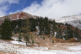
We went up to the top of the mountain first. The sun came out and it made for some amazing pictures. We took advantage of the scenery, getting lots of good pictures of our vehicles in the sun.

We spent a lot of time up at the top, but eventually we went back down and headed over to the mines. It started to get a little chilly, but we all still wandered around to check everything out. Everything metal was littered in bullet holes, and we wondered how long ago that happened.

The scenery was gorgeous and we had the place to ourselves. We hung out for awhile, but we eventually went back down. The road by all of the campers had lots of people cruising around on ATVs but the traffic wasn't too bad.

We aired up at the picnic area near the trailhead, which was convenient. We had dinner in Bailey and the sun wasn't even down yet. It seemed like we got a lot accomplished in a short amount of time, which was pretty cool. It was a great day!

at_the_top
basin
cabin_at_the_crossroads
cabin
cows_part_1
cows_part_2
downed_tree
early_trail
gate
geneva_creek
gorgeous
little_waterfall
low_clouds
marmot
marsh
matt_and_walt_to_the_top
matt_at_the_crossroads
matt_at_the_mines
matt_at_the_top_part_1
matt_at_the_top_part_2
matt_at_the_top_part_3
matt_at_the_top_part_4
matt_at_the_top_part_5
matt_at_the_top_part_6
matt_coming_down
matt_crazy_parking
matt_in_the_basin
matt_near_the_old_truck
matt_to_the_top_part_1
matt_to_the_top_part_2
matt_to_the_top_part_3
matt_to_the_top_part_4
monica_and_matt
monica_at_the_crossroads
monica_at_the_mines
monica_at_the_top_part_1
monica_at_the_top_part_2
monica_at_the_top_part_3
monica_at_the_top_part_4
monica_at_the_top_part_5
monica_parked
mountain_home
mountain_view
nice_view
old_building
old_mill
on_the_way_down
over_to_the_mines
pond_at_the_crossroads
shack
shadows
shallow_water
snow
stream_crossing
switchbacks_to_climb
through_a_building
trail_to_the_mines
up_to_the_top_part_1
up_to_the_top_part_2
up_to_the_top_part_3
uphill_climb
view_from_the_top_part_1
view_from_the_top_part_2
view_from_the_top_part_3
walt_and_monica_at_the_top
walt_at_the_crossroads
walt_at_the_mines
walt_at_the_top_part_1
walt_at_the_top_part_2
walt_to_the_top_part_1
walt_to_the_top_part_2
walt_to_the_top_part_3
walt_to_the_top_part_4
walt_to_the_top_part_5
water_crossing
waterfall

Reports from Other Days: 2

Use the arrows or dots to flip through the previews of the other reports for Geneva Creek. Click one of them to read more and see all of the photos from that day.

September 24, 2016

Led by Monica I.
The official TrailDamage.com camera finally kicked the bucket after being filled with dirt and sand for years. We asked our followers for donations and they responded right away, funding a new camera for the group. We did what we could to repay the favor, sponsoring them with membership. Joe joined…
»
  • 1
  • 2
Join Us!
If you aren’t a Member or Subscriber, you can’t see all of the content on this site. Get membership information to see why this site is best when you join and log in

Information for Subscribers

When you log in you’ll see more information here:

  • Recent Community Forum posts
  • Recent polls
  • Upcoming Events you can attend
  • Links to online users

© 2000-2022 · TrailDamage.com · Terms and Conditions · About · Contact
Trail information is only accurate on the date posted. Trails may have changed or closed since that date. Use this information for historical purposes only.
Contact the Forest Service or Bureau of Land Management for up-to-date trail information.

/* ----------------------------------------- */ /* View slug: reports-other-reports-for-same-trail-slider - start */ /* ----------------------------------------- */ /* place the prev/next controls on the sides */ .td-transition-controls .wpv-filter-next-link, .td-transition-controls .wpv-filter-previous-link { border: none; font-size: 300%; position: absolute; top: 70px; } .td-transition-controls .wpv-filter-previous-link { left: 0; } .td-transition-controls .wpv-filter-next-link { right: 0; } /* center the page selector horizonatally */ .td-transition-controls ul.wpv_pagination_dots { text-align: center; margin-top: 10px; } /* center the page selector horizonatally */ .td-transition-controls ul.wpv_pagination_dots li.wpv_pagination_dots_item, .td-transition-controls .wpv_pagination_dots li a { display: inline-block; float: none; } /* remove the default styles */ .td-transition-controls .wpv_pagination_dots li a { text-decoration: none; border-bottom: none; } .td-slider-container { padding: 0 25px; margin-bottom: 20px; position: relative; width:100%; display:table; } .td-slides { position: relative; } .td-slides-image { float:left; display:table-cell; } .td-slides-image img { border:1px solid #c0c0c0; } .td-slides-content { padding:4px 4px 4px 10px; border-top:1px solid #c0c0c0; border-right:1px solid #c0c0c0; border-bottom:1px solid #c0c0c0; display:table-cell; height:227px; overflow:hidden; } .td-slides-content h3 { margin-top:8px; } .td-slides-leader { font-size:smaller; margin-top:4px; } /* ----------------------------------------- */ /* View slug: reports-other-reports-for-same-trail-slider - end */ /* ----------------------------------------- */
/* ----------------------------------------- */ /* Content Template: Template for a Single Report - start */ /* ----------------------------------------- */ .entry-header { display:none; } .entry-content h1 { margin-top:16px; padding-top:0; } h1 a { color:#222; } h1 a:hover { color:#666; } p.entry-meta { font-size:small; } #report-body-spacer { clear:both; width:100%; height:20px; } #addtoany-bar { margin-bottom:2em; text-align:center; } .category-reports .post-info .author, .post-info .date { display: none; } .addthis_recommended_horizontal { text-align:center !important; } /* ----------------------------------------- */ /* Content Template: Template for a Single Report - end */ /* ----------------------------------------- */ /* ----------------------------------------- */ /* Content Template: Loop item in REPORTS Runners - start */ /* ----------------------------------------- */ #runners-container { width:100%; clear:both; } .runner { border:1px solid #c0c0c0; margin:0 6px 6px 0; float:left; width:49%; height:81px; } .runner-image { float: left; } .runner-image img { margin:2px 10px 0 2px; height:75px; width:75px; } .runner-name { text-transform:uppercase; } .runner-name a { color:#222; } .runner-name a:hover { color:#666; } .runner-vehicle { font-size:small; } @media only screen and (max-width: 768px) { .runner { width:100%; } } /* ----------------------------------------- */ /* Content Template: Loop item in REPORTS Runners - end */ /* ----------------------------------------- */