TrailDamage.com

Photos, videos and information about 4x4 trails in Colorado and Utah

  • Trails
    • Colorado
    • Utah
  • Reports
    • Featured Photos
    • Featured Videos
    • Reports Calendar
  • Members
  • Search
  • Trail Damage Winners
  • FAQ
  • Community
  • Upcoming Events
  • Membership
  • Log In
  • Facebook
  • Instagram
  • RSS
  • Twitter
  • YouTube

Fix It Pass 170513

May 13, 2017 by Monica

Fix It Pass

Trail Run on May 13, 2017
Report and photos by Monica I., Trail Leader
View trail information for Fix It Pass

Mike S.
Silver 2004 Jeep Wrangler Rubicon
Matt K.
White 2016 Jeep Wrangler Unlimited Rubicon
Walt S.
Gray 2022 Jeep Wrangler Unlimited Rubicon 392

Fix It Pass was our destination because of the chunky, challenging hill up to the pass. We did the trail in the other direction the last time, but this time we were planning on climbing it. We did the easy stretch at the beginning to go under I-70 and get to Devil's Racetrack, did that trail, and then we started heading back to I-70 from the far end of the Fix It Pass trail.

That end of the trail is easy and in a wide wash, but it's washboarded the entire way. We stopped at Swazey's Arch for a break from the bumpiness and to enjoy the scenery. It's a big arch.

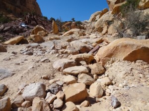
We cruised along, and we happily found Fix It Pass and the climb with no one on it. It was rocky, and the middle of it looked challenging. Mike went first, slowly working his way up it. He made the corner, and found a great line over the big rock where it was finally flat before heading uphill again. He stopped there to spot the others through it if they needed it.

It was Matt's first trip to Utah with his new Jeep, and the four-door JK had a much different wheelbase than his old, two-door TJ. It was going well until he ended up sliding off of a rock and got his differential caught on the big rock. He backed out and tried a few different lines, but nothing was working. He ended up getting really close to the edge of the cliff to get around it, but then he was through.

Walt watched all of this and chose his line. He got a little hung up on the big rock, but made it through pretty quickly. What a blast!

The rest of the climb was fun, but no one had any issues. Then we had a lot of awesome scenery as we worked our way to the next big hill. That hill was loose and fun, and everyone had a good time scrambling up it.

Once we were past that obstacle, the rest was easy. We went by the trailhead for Devil's Racetrack again, making a full loop. After we were under the highway we looped back around to the I-70 exit and wide spot where we aired up. This is such a good loop and a great day, making it one of our favorites.

P1040096
P1040097
P1040100
P1040103
P1040104
P1040105
P1040308
P1040310
P1040311
P1040312
P1040314
P1040315
P1040316
P1040319
P1040320
P1040322
P1040323
P1040325
P1040326
P1040327
P1040328
P1040329
P1040332
P1040333
P1040334
P1040335
P1040336
P1040337-1
P1040337-3
P1040337-4
P1040337
P1040338
P1040339
P1040340
P1040341
P1040343
P1040347
P1040348
P1040350
P1040351
P1040352
P1040353
P1040355
P1040356
P1040358
P1040359
P1040360
P1040361
P1040362
P1040364
P1040368
P1040369
P1040371
P1040372
P1040373
P1040374
P1040375
P1040376
P1040377
P1040378
P1040379
P1040381
P1040383
P1040384
P1040385
P1040387
P1040388
P1040393
P1040394
P1040395
P1040396
P1040397
P1040398
P1040399
P1040400
P1040401
P1040403
P1040404
P1040405
P1040407

Report from a Different Day

May 26, 2013

Led by Monica I.
There were so many trails in the San Rafael Swell and so little time. We stopped at the kiosk at the I-70 exit to Temple Mountain Road and contemplated the map. We soon found the two trails marked the most difficult for 4×4 vehicles, a loop made by Fix It…
Join Us!
If you aren’t a Member or Subscriber, you can’t see all of the content on this site. Get membership information to see why this site is best when you join and log in

Information for Subscribers

When you log in you’ll see more information here:

  • Recent Community Forum posts
  • Recent polls
  • Upcoming Events you can attend
  • Links to online users

© 2000-2022 · TrailDamage.com · Terms and Conditions · About · Contact
Trail information is only accurate on the date posted. Trails may have changed or closed since that date. Use this information for historical purposes only.
Contact the Forest Service or Bureau of Land Management for up-to-date trail information.

/* ----------------------------------------- */ /* View slug: reports-other-reports-for-same-trail-slider - start */ /* ----------------------------------------- */ /* place the prev/next controls on the sides */ .td-transition-controls .wpv-filter-next-link, .td-transition-controls .wpv-filter-previous-link { border: none; font-size: 300%; position: absolute; top: 70px; } .td-transition-controls .wpv-filter-previous-link { left: 0; } .td-transition-controls .wpv-filter-next-link { right: 0; } /* center the page selector horizonatally */ .td-transition-controls ul.wpv_pagination_dots { text-align: center; margin-top: 10px; } /* center the page selector horizonatally */ .td-transition-controls ul.wpv_pagination_dots li.wpv_pagination_dots_item, .td-transition-controls .wpv_pagination_dots li a { display: inline-block; float: none; } /* remove the default styles */ .td-transition-controls .wpv_pagination_dots li a { text-decoration: none; border-bottom: none; } .td-slider-container { padding: 0 25px; margin-bottom: 20px; position: relative; width:100%; display:table; } .td-slides { position: relative; } .td-slides-image { float:left; display:table-cell; } .td-slides-image img { border:1px solid #c0c0c0; } .td-slides-content { padding:4px 4px 4px 10px; border-top:1px solid #c0c0c0; border-right:1px solid #c0c0c0; border-bottom:1px solid #c0c0c0; display:table-cell; height:227px; overflow:hidden; } .td-slides-content h3 { margin-top:8px; } .td-slides-leader { font-size:smaller; margin-top:4px; } /* ----------------------------------------- */ /* View slug: reports-other-reports-for-same-trail-slider - end */ /* ----------------------------------------- */
/* ----------------------------------------- */ /* Content Template: Template for a Single Report - start */ /* ----------------------------------------- */ .entry-header { display:none; } .entry-content h1 { margin-top:16px; padding-top:0; } h1 a { color:#222; } h1 a:hover { color:#666; } p.entry-meta { font-size:small; } #report-body-spacer { clear:both; width:100%; height:20px; } #addtoany-bar { margin-bottom:2em; text-align:center; } .category-reports .post-info .author, .post-info .date { display: none; } .addthis_recommended_horizontal { text-align:center !important; } /* ----------------------------------------- */ /* Content Template: Template for a Single Report - end */ /* ----------------------------------------- */ /* ----------------------------------------- */ /* Content Template: Loop item in REPORTS Runners - start */ /* ----------------------------------------- */ #runners-container { width:100%; clear:both; } .runner { border:1px solid #c0c0c0; margin:0 6px 6px 0; float:left; width:49%; height:81px; } .runner-image { float: left; } .runner-image img { margin:2px 10px 0 2px; height:75px; width:75px; } .runner-name { text-transform:uppercase; } .runner-name a { color:#222; } .runner-name a:hover { color:#666; } .runner-vehicle { font-size:small; } @media only screen and (max-width: 768px) { .runner { width:100%; } } /* ----------------------------------------- */ /* Content Template: Loop item in REPORTS Runners - end */ /* ----------------------------------------- */