TrailDamage.com

Photos, videos and information about 4x4 trails in Colorado and Utah

  • Trails
    • Colorado
    • Utah
  • Reports
    • Featured Photos
    • Featured Videos
    • Reports Calendar
  • Members
  • Search
  • Trail Damage Winners
  • FAQ
  • Community
  • Upcoming Events
  • Membership
  • Log In
  • Facebook
  • Instagram
  • RSS
  • Twitter
  • YouTube

Engineer Pass 090825

August 25, 2009 by Monica

Engineer Pass

Trail Run on August 25, 2009
Report and photos by Monica I., Trail Leader
View trail information for Engineer Pass

Gary R.
Yellow 1978 Jeep CJ-7
Walt S.
Gray 2022 Jeep Wrangler Unlimited Rubicon 392
Mike S.
Silver 2004 Jeep Wrangler Rubicon
Monica I.
Red 2010 Jeep Wrangler Rubicon
Bob R.
Green 2003 Jeep Wrangler Rubicon
Dave E.
Blue 1999 Jeep Cherokee

Engineer Pass marked the second half of the "Alpine Loop" and we did it right after finishing Cinnamon Pass. Monica quickly ran down to the Engineer Pass trailhead at Animas Forks and then back up to the intersection with Cinnamon Pass, just to get it on the GPS. Then we were off, in a parade of other vehicles.

We saw ATVs in both directions and vehicles ahead of us as well as behind us. It was busy for a Tuesday! The initial climb up the switchbacks to Oh Point were dramatic and gorgeous. This is definitely not a fun place for someone afraid of shelf roads. It was like we were driving off the edge of the Earth.

We made it through "rush hour" and parked at Oh Point with a couple of other Jeeps. Monica and Bob had both been in this area before but they hadn't completed the trail. It was very, very foggy that year and you couldn't see very far. We remembered how intimidating that made everything, and we appreciated the sunny weather we had this time.

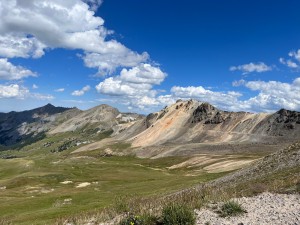
The stop at Oh Point is definitely worth it. The views are amazing, providing some great photo opportunities. We stayed for just a bit, watching the traffic on the main trail. We got in our Jeeps to leave just as a Suburban worked its way over to us, so we waited for a bit until they made it to Oh Point so we could leave. It was such a busy area.

It felt very "Alpine" as we traveled to Engineer Pass and started heading down the mountain. There were no trees, and everything was very barren. It was beautiful. Unfortunately, it wasn't long before we were heading into the trees.

We found the Hurricane Basin trail soon after Oh Point, which we ran up and back down, enjoying it thoroughly. Once we were back on Engineer Pass, it was pretty easy going. We didn't see as much traffic anymore, and the trail went by pretty quickly.

We stopped at the Whitmore Falls overlook, and almost everyone walked to the overlook spot to check it out. No one was motivated enough to hike all the way down, but we all enjoyed the views from the man-made viewing area. The waterfalls are one of the best things about the San Juan Mountains, and we were happy to be snapping pictures of one of the big ones.

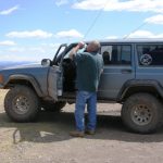
Gary had noticed earlier that one of his rear hubs was getting really hot. He was worried that one of his bearings was shot, and that seemed to be the case. He kept an eye on it, but things weren't looking good.

We continued on, enjoying a short diversion along the North Herman Road trail before heading back to Lake City. We had a good dinner and managed to turn in before it got too late. We didn't even need to air up because the next morning's trails were nearby. We finally finished the Alpine Loop and things were good!

around_a_bend
big_view
bob_at_oh_point
bonanza_empire_chief_mine_part_1
bonanza_empire_chief_mine_part_2
bonanza_empire_chief_mine_part_3
bonanza_empire_chief_mine_signs
bridge
climbing_away_from_animas_forks
dave_at_oh_point
descent
down_from_the_pass
early_view
engineer_pass_signs
gary_at_oh_point
into_trees
mike_at_oh_point
monica_at_oh_point
mountain_stream
old_cabin
old_switchbacks
on_the_trail
open_road
parked_at_oh_point
rose_lime_kiln_sign
rose_lime_kiln
serious_mountains
shelf_road
steep_climb
stream
walt_at_oh_point
walt_on_the_whitmore_falls_hike
water_flow
whitmore_falls_part_1
whitmore_falls_part_2
whitmore_falls_part_3
whitmore_falls_part_4
whitmore_falls_sign
wildhorse_peak
Join Us!
If you aren’t a Member or Subscriber, you can’t see all of the content on this site. Get membership information to see why this site is best when you join and log in

Information for Subscribers

When you log in you’ll see more information here:

  • Recent Community Forum posts
  • Recent polls
  • Upcoming Events you can attend
  • Links to online users

© 2000-2022 · TrailDamage.com · Terms and Conditions · About · Contact
Trail information is only accurate on the date posted. Trails may have changed or closed since that date. Use this information for historical purposes only.
Contact the Forest Service or Bureau of Land Management for up-to-date trail information.

/* ----------------------------------------- */ /* View slug: reports-other-reports-for-same-trail-slider - start */ /* ----------------------------------------- */ /* place the prev/next controls on the sides */ .td-transition-controls .wpv-filter-next-link, .td-transition-controls .wpv-filter-previous-link { border: none; font-size: 300%; position: absolute; top: 70px; } .td-transition-controls .wpv-filter-previous-link { left: 0; } .td-transition-controls .wpv-filter-next-link { right: 0; } /* center the page selector horizonatally */ .td-transition-controls ul.wpv_pagination_dots { text-align: center; margin-top: 10px; } /* center the page selector horizonatally */ .td-transition-controls ul.wpv_pagination_dots li.wpv_pagination_dots_item, .td-transition-controls .wpv_pagination_dots li a { display: inline-block; float: none; } /* remove the default styles */ .td-transition-controls .wpv_pagination_dots li a { text-decoration: none; border-bottom: none; } .td-slider-container { padding: 0 25px; margin-bottom: 20px; position: relative; width:100%; display:table; } .td-slides { position: relative; } .td-slides-image { float:left; display:table-cell; } .td-slides-image img { border:1px solid #c0c0c0; } .td-slides-content { padding:4px 4px 4px 10px; border-top:1px solid #c0c0c0; border-right:1px solid #c0c0c0; border-bottom:1px solid #c0c0c0; display:table-cell; height:227px; overflow:hidden; } .td-slides-content h3 { margin-top:8px; } .td-slides-leader { font-size:smaller; margin-top:4px; } /* ----------------------------------------- */ /* View slug: reports-other-reports-for-same-trail-slider - end */ /* ----------------------------------------- */
/* ----------------------------------------- */ /* Content Template: Template for a Single Report - start */ /* ----------------------------------------- */ .entry-header { display:none; } .entry-content h1 { margin-top:16px; padding-top:0; } h1 a { color:#222; } h1 a:hover { color:#666; } p.entry-meta { font-size:small; } #report-body-spacer { clear:both; width:100%; height:20px; } #addtoany-bar { margin-bottom:2em; text-align:center; } .category-reports .post-info .author, .post-info .date { display: none; } .addthis_recommended_horizontal { text-align:center !important; } /* ----------------------------------------- */ /* Content Template: Template for a Single Report - end */ /* ----------------------------------------- */ /* ----------------------------------------- */ /* Content Template: Loop item in REPORTS Runners - start */ /* ----------------------------------------- */ #runners-container { width:100%; clear:both; } .runner { border:1px solid #c0c0c0; margin:0 6px 6px 0; float:left; width:49%; height:81px; } .runner-image { float: left; } .runner-image img { margin:2px 10px 0 2px; height:75px; width:75px; } .runner-name { text-transform:uppercase; } .runner-name a { color:#222; } .runner-name a:hover { color:#666; } .runner-vehicle { font-size:small; } @media only screen and (max-width: 768px) { .runner { width:100%; } } /* ----------------------------------------- */ /* Content Template: Loop item in REPORTS Runners - end */ /* ----------------------------------------- */