TrailDamage.com

Photos, videos and information about 4x4 trails in Colorado and Utah

  • Trails
    • Colorado
    • Utah
  • Reports
    • Featured Photos
    • Featured Videos
    • Reports Calendar
  • Members
  • Search
  • Trail Damage Winners
  • FAQ
  • Community
  • Upcoming Events
  • Membership
  • Log In
  • Facebook
  • Instagram
  • RSS
  • Twitter
  • YouTube

Dome Plateau 071017

October 17, 2007 by Monica

Dome Plateau

Trail Run on October 17, 2007
Report and photos by Monica I., Trail Leader
View trail information for Dome Plateau

Mike S.
Silver 2004 Jeep Wrangler Rubicon
Bob R.
Green 2003 Jeep Wrangler Rubicon
Michael M.
Black 2006 Jeep Wrangler Unlimited Rubicon
Don W.
Silver 2005 Jeep Wrangler Rubicon

This was a new trail for the group and we were excited to see what it had in store for us. We knew it was going to be a long trail, and we hoped to see lots of different scenery. We weren't disappointed!

The trailhead was easy to find, and we were soon aired down, disconnected and ready to go. The trail was easy to find and we were soon traveling over rocky sections with ledges and bits of slickrock in the sand. We had barely gotten started and the trail was already fun.

After lots of play sections we ended up on sand. Thankfully, we had the intersection for the first overlook marked on the GPS -- otherwise we wouldn't have found it. The road to the overlook was straight and easy, and we bypassed a shelf section on the way there. We did it on the way back, which was fun.

The overlook itself was okay, though it didn't get us all the way to the edge of the cliff. You could see a bit of the river, but we were still pretty far from the edge and the ability to see the whole thing. It looked like a hike to the edge would be challenging, and we skipped it to save the time. The views of the Dewey Bridge on the way back were pretty cool.

Again and Again Hill snuck up on us. It is a downhill trip, and there are two very distinct trips down it. Everyone took the right side on the way down, and then the other side on the way up. We all went down it again and parked at the bottom, thinking this would be a good place for lunch. It was a great lunch, and as soon as we started up again it started raining.

Luckily, the rain didn't last long. The sun came back out and we found ourselves on a wide, maintained road. We followed the road briefly and then we all had to look for a little while until we found the intersection for the next section of trail. The wide road is maintained well enough to leave berms on the edges of the road, so the trail intersection was difficult to find.

It was worth the effort, though. We all really enjoyed this next part of the trail. It felt like people hadn't been on it in a long time, and that maybe only a few see it every year. We followed some ATV tracks, but that's all we saw. It was really cool.

Soon we came out on a wide road again and turned left at the 5-way intersection. We followed the fence all the way to the second overlook.

The second overlook was absolutely amazing and nothing like the first one. We could walk up to the edge and see all of the valley below us. Fisher Towers were directly across from us, and we couldn't get enough of the views. This point was the "midway" point for the trail and we were all awe-struck.

We followed an easy trail back, covered with lots of different vehicle tracks. This is a popular section. It must be, with an overlook like that.

When we got to the intersection with Dome Wash, we went down that optional way (of course). It seemed like we lost the route at times, so sometimes we had to walk ahead to find it again. It ended up being pretty obvious, following the bottom of the wash all the way through.

The obstacles in the wash were a blast. It would have been even more fun to go up them, actually. We'll have to try that next time.

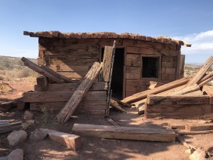
When we intersected with the main trail again, we went back up it to see the mining buildings and the mine. It was some good scenery, but we didn't stay long.

We soon found ourselves at the end of the trail and back at the highway. We turned to go check out Delores River on the way back to Moab. Dome Plateau ended up being a great time, with one of the best overlooks out there.

again_and_again_hill
airing_down
big_view
bob_airing_down
bob_and_don_on_again_and_again_hill
bob_at_the_second_overlook_part_1
bob_at_the_second_overlook_part_2
bob_at_the_second_overlook_part_3
bob_down_again_and_again_hill_part_1
bob_down_again_and_again_hill_part_2
bob_down_again_and_again_hill_part_3
bob_down_ledges_part_1
bob_down_ledges_part_2
bob_down_ledges_part_3
bob_in_the_wash_part_1
bob_in_the_wash_part_2
bob_in_the_wash_part_3
bob_in_the_wash_part_4
bob_in_the_wash_part_5
bob_in_the_wash_part_6
bob_in_the_wash_part_7
bob_up_again_and_again_hill_part_1
bob_up_again_and_again_hill_part_2
bob_up_again_and_again_hill_part_3
bumpy_trail
cave
caves
colorful
cool_cloud
cup_handle_arch_part_1
cup_handle_arch_part_2
dewey_bridge_part_1
dewey_bridge_part_2
dewey_bridge_part_3
dewey_bridge_part_4
dirt_hill
don_airing_down
don_at_the_second_overlook_part_1
don_at_the_second_overlook_part_2
don_down_again_and_again_hill_part_1
don_down_again_and_again_hill_part_2
don_down_again_and_again_hill_part_3
don_down_again_and_again_hill_part_4
don_down_again_and_again_hill_part_5
don_down_ledges_part_1
don_down_ledges_part_2
don_down_ledges_part_3
don_flexing
don_in_the_wash_part_1
don_in_the_wash_part_2
don_in_the_wash_part_3
don_in_the_wash_part_4
don_in_the_wash_part_5
don_in_the_wash_part_6
don_in_the_wash_part_7
don_in_the_wash_part_8
don_up_again_and_again_hill_part_1
don_up_again_and_again_hill_part_2
early_rocky_section
end_of_the_mine
end_of_the_trail
fencing_at_the_end
fisher_towers_from_the_second_overlook
fun_trail
graded_slickrock
grasses
jeeps_at_the_first_overlook
la_sal_mountains
long_trail
mellow_trail
michael_airing_down
michael_down_again_and_again_hill_part_1
michael_down_again_and_again_hill_part_2
michael_down_ledges_part_1
michael_down_ledges_part_2
michael_in_the_wash_part_1
michael_in_the_wash_part_2
michael_in_the_wash_part_3
michael_in_the_wash_part_4
michael_in_the_wash_part_5
michael_in_the_wash_part_6
michael_in_the_wash_part_7
michael_up_again_and_again_hill_part_1
michael_up_again_and_again_hill_part_2
michael_up_again_and_again_hill_part_3
mike_airing_down
mike_down_again_and_again_hill
mike_down_ledges_part_1
mike_down_ledges_part_2
mike_in_the_wash_part_1
mike_in_the_wash_part_2
mike_in_the_wash_part_3
mike_in_the_wash_part_4
mike_in_the_wash_part_5
mike_in_the_wash_part_6
mike_in_the_wash_part_7
mike_on_the_trail
mike_up_again_and_again_hill_part_1
mike_up_again_and_again_hill_part_2
mike_up_again_and_again_hill_part_3
mine_entrance
mining_buildings_part_1
mining_buildings_part_2
mining_buildings_part_3
old_engine_by_the_mine
old_fence
out_of_the_wash
rain_coming
red_ledges
rock_formation
sand_and_slickrock
sandstone_layers
sandy_hill
shrine
sign_at_the_end
small_ledges
smooth
start_of_the_trail
three_wisemen
trail_sign
trail_to_the_second_overlook
twisty_hill_climb
view_from_the_first_overlook_part_1
view_from_the_first_overlook_part_2
view_from_the_second_overlook_part_1
view_from_the_second_overlook_part_2
view_from_the_second_overlook_part_3
view_from_the_second_overlook_part_4
view_from_the_second_overlook_part_5
view_from_the_second_overlook_part_6
view_from_the_second_overlook_part_7
view_from_the_second_overlook_part_8
view_from_the_trailhead
wash_crossing
wash_obstacle_1
wash_obstacle_2

Reports from Other Days: 3

Use the arrows or dots to flip through the previews of the other reports for Dome Plateau. Click one of them to read more and see all of the photos from that day.

October 24, 2020

Led by Matt K.
Dome Plateau was the last trail for the fall Moab run this year. It was nice and sunny, but a slightly cool day. We aired down in the parking lot next to the Dewey Bridge. The start of Dome Plateau was very rocky up to the gate. We did see…
»
  • 1
  • 2
  • 3
Join Us!
If you aren’t a Member or Subscriber, you can’t see all of the content on this site. Get membership information to see why this site is best when you join and log in

Information for Subscribers

When you log in you’ll see more information here:

  • Recent Community Forum posts
  • Recent polls
  • Upcoming Events you can attend
  • Links to online users

© 2000-2022 · TrailDamage.com · Terms and Conditions · About · Contact
Trail information is only accurate on the date posted. Trails may have changed or closed since that date. Use this information for historical purposes only.
Contact the Forest Service or Bureau of Land Management for up-to-date trail information.

/* ----------------------------------------- */ /* View slug: reports-other-reports-for-same-trail-slider - start */ /* ----------------------------------------- */ /* place the prev/next controls on the sides */ .td-transition-controls .wpv-filter-next-link, .td-transition-controls .wpv-filter-previous-link { border: none; font-size: 300%; position: absolute; top: 70px; } .td-transition-controls .wpv-filter-previous-link { left: 0; } .td-transition-controls .wpv-filter-next-link { right: 0; } /* center the page selector horizonatally */ .td-transition-controls ul.wpv_pagination_dots { text-align: center; margin-top: 10px; } /* center the page selector horizonatally */ .td-transition-controls ul.wpv_pagination_dots li.wpv_pagination_dots_item, .td-transition-controls .wpv_pagination_dots li a { display: inline-block; float: none; } /* remove the default styles */ .td-transition-controls .wpv_pagination_dots li a { text-decoration: none; border-bottom: none; } .td-slider-container { padding: 0 25px; margin-bottom: 20px; position: relative; width:100%; display:table; } .td-slides { position: relative; } .td-slides-image { float:left; display:table-cell; } .td-slides-image img { border:1px solid #c0c0c0; } .td-slides-content { padding:4px 4px 4px 10px; border-top:1px solid #c0c0c0; border-right:1px solid #c0c0c0; border-bottom:1px solid #c0c0c0; display:table-cell; height:227px; overflow:hidden; } .td-slides-content h3 { margin-top:8px; } .td-slides-leader { font-size:smaller; margin-top:4px; } /* ----------------------------------------- */ /* View slug: reports-other-reports-for-same-trail-slider - end */ /* ----------------------------------------- */
/* ----------------------------------------- */ /* Content Template: Template for a Single Report - start */ /* ----------------------------------------- */ .entry-header { display:none; } .entry-content h1 { margin-top:16px; padding-top:0; } h1 a { color:#222; } h1 a:hover { color:#666; } p.entry-meta { font-size:small; } #report-body-spacer { clear:both; width:100%; height:20px; } #addtoany-bar { margin-bottom:2em; text-align:center; } .category-reports .post-info .author, .post-info .date { display: none; } .addthis_recommended_horizontal { text-align:center !important; } /* ----------------------------------------- */ /* Content Template: Template for a Single Report - end */ /* ----------------------------------------- */ /* ----------------------------------------- */ /* Content Template: Loop item in REPORTS Runners - start */ /* ----------------------------------------- */ #runners-container { width:100%; clear:both; } .runner { border:1px solid #c0c0c0; margin:0 6px 6px 0; float:left; width:49%; height:81px; } .runner-image { float: left; } .runner-image img { margin:2px 10px 0 2px; height:75px; width:75px; } .runner-name { text-transform:uppercase; } .runner-name a { color:#222; } .runner-name a:hover { color:#666; } .runner-vehicle { font-size:small; } @media only screen and (max-width: 768px) { .runner { width:100%; } } /* ----------------------------------------- */ /* Content Template: Loop item in REPORTS Runners - end */ /* ----------------------------------------- */