TrailDamage.com

Photos, videos and information about 4x4 trails in Colorado and Utah

  • Trails
    • Colorado
    • Utah
  • Reports
    • Featured Photos
    • Featured Videos
    • Reports Calendar
  • Members
  • Search
  • Trail Damage Winners
  • FAQ
  • Community
  • Upcoming Events
  • Membership
  • Log In
  • Facebook
  • Instagram
  • RSS
  • Twitter
  • YouTube

Democrat Mountain 101106

November 6, 2010 by Matt Kuczborski

Democrat Mountain

Trail Run on November 6, 2010
Report and photos by Matt K., Trail Leader
View trail information for Democrat Mountain

Walt S.
Gray 2018 Jeep Wrangler Unlimited Rubicon
Gary R.
Yellow 1978 Jeep CJ-7
Matt K.
White 2016 Jeep Wrangler Unlimited Rubicon

Democrat Mountain was our first run of the day. We aired down by a small park just off of Main Street in Empire. It looked like it was going to be a nice sunny day with decent temperatures for November.

We soon made our way to Democrat Mountain. We drove the first short section of Bard Creek until we found the trailhead for Democrat Mountain. There is a sign at the trailhead that says "To Democrat and Republican Mountain" so it was pretty easy to find. We turned left and started up the trail.

Shortly after turning onto the trail, we started up a hill that was entirely covered with ice. We had some fun going up the small hill. Mark F. was with us up to that point, but he decided not to risk the icy hill. Instead, he waited at the trailhead for our return.

Democrat Mountain has some switchbacks at the beginning and they were covered with a bit of snow. That made the trail really fun to drive on. Nobody had any issues with the snow on the trail, though we all enjoyed it.

Then we came to a steep, uphill switchback. Matt made it up with no issues. Gary and Walt had to try a few times to get up the switchback, but it all worked out in the end. After the switchback, the snow started to get deeper.

We kept making our way up the trail. After a few more switchbacks, we were more then half way to the top of Democrat Mountain.

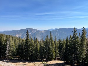
As we got up to around 11,500 feet, the snow was much deeper and it was getting harder to find the trail. So we stopped at a small area that did not have too much snow on it and walked more of what we thought was the trail. The snow was up to our knees at that elevation, so we stopped walking the trail and decided not to drive up any farther. We turned around and started on our way back down to meet back up with Mark.

We did have a lot of fun with the snow on the trail, and we were already looking forward to returning to see the rest of it. Soon we were on our way to finish Bard Creek.

airing_down_part_1
airing_down_part_2
aspen
deep_snow
gary_in_snow_part_1
gary_in_snow_part_2
gary_in_snow_part_3
gary_on_ice
jeeps_on_the_trail
looking_down_bard_creek
matt_in_snow
matt_on_the_trail
snow_on_the_trail_part_1
snow_on_the_trail_part_2
snow_on_the_trail_part_3
snow_on_the_trail_part_4
snow_on_the_trail_part_5
snow_on_the_trail_part_6
snow_on_the_trail_part_7
snow_on_the_trail_part_8
snow
start_of_the_trail
trail_part_1
trail_part_2
trail_part_3
trail_part_4
trail_part_5
trail_part_6
view_part_1
view_part_2
view_part_3
view_part_4
view_part_5
view_part_6
walt_in_snow
walt_on_ice

Report from a Different Day

August 13, 2011

Led by Monica I.
After we did Bard Creek we met Mark and the group headed up to Democrat Mountain. It was definitely a bumpy climb to the top but it was fun. The bumps and the climbing seemed to go on forever. There was a group of hikers that we passed and we…
Join Us!
If you aren’t a Member or Subscriber, you can’t see all of the content on this site. Get membership information to see why this site is best when you join and log in

Information for Subscribers

When you log in you’ll see more information here:

  • Recent Community Forum posts
  • Recent polls
  • Upcoming Events you can attend
  • Links to online users

© 2000-2021 · TrailDamage.com · Terms and Conditions · About · Contact
Trail information is only accurate on the date posted. Trails may have changed or closed since that date. Use this information for historical purposes only.
Contact the Forest Service or Bureau of Land Management for up-to-date trail information.

/* ----------------------------------------- */ /* View slug: reports-other-reports-for-same-trail-slider - start */ /* ----------------------------------------- */ /* place the prev/next controls on the sides */ .td-transition-controls .wpv-filter-next-link, .td-transition-controls .wpv-filter-previous-link { border: none; font-size: 300%; position: absolute; top: 70px; } .td-transition-controls .wpv-filter-previous-link { left: 0; } .td-transition-controls .wpv-filter-next-link { right: 0; } /* center the page selector horizonatally */ .td-transition-controls ul.wpv_pagination_dots { text-align: center; margin-top: 10px; } /* center the page selector horizonatally */ .td-transition-controls ul.wpv_pagination_dots li.wpv_pagination_dots_item, .td-transition-controls .wpv_pagination_dots li a { display: inline-block; float: none; } /* remove the default styles */ .td-transition-controls .wpv_pagination_dots li a { text-decoration: none; border-bottom: none; } .td-slider-container { padding: 0 25px; margin-bottom: 20px; position: relative; width:100%; display:table; } .td-slides { position: relative; } .td-slides-image { float:left; display:table-cell; } .td-slides-image img { border:1px solid #c0c0c0; } .td-slides-content { padding:4px 4px 4px 10px; border-top:1px solid #c0c0c0; border-right:1px solid #c0c0c0; border-bottom:1px solid #c0c0c0; display:table-cell; height:227px; overflow:hidden; } .td-slides-content h3 { margin-top:8px; } .td-slides-leader { font-size:smaller; margin-top:4px; } /* ----------------------------------------- */ /* View slug: reports-other-reports-for-same-trail-slider - end */ /* ----------------------------------------- */
/* ----------------------------------------- */ /* Content Template: Template for a Single Report - start */ /* ----------------------------------------- */ .entry-header { display:none; } .entry-content h1 { margin-top:16px; padding-top:0; } h1 a { color:#222; } h1 a:hover { color:#666; } p.entry-meta { font-size:small; } #report-body-spacer { clear:both; width:100%; height:20px; } #addtoany-bar { margin-bottom:2em; text-align:center; } .category-reports .post-info .author, .post-info .date { display: none; } .addthis_recommended_horizontal { text-align:center !important; } /* ----------------------------------------- */ /* Content Template: Template for a Single Report - end */ /* ----------------------------------------- */ /* ----------------------------------------- */ /* Content Template: Loop item in REPORTS Runners - start */ /* ----------------------------------------- */ #runners-container { width:100%; clear:both; } .runner { border:1px solid #c0c0c0; margin:0 6px 6px 0; float:left; width:49%; height:81px; } .runner-image { float: left; } .runner-image img { margin:2px 10px 0 2px; height:75px; width:75px; } .runner-name { text-transform:uppercase; } .runner-name a { color:#222; } .runner-name a:hover { color:#666; } .runner-vehicle { font-size:small; } @media only screen and (max-width: 768px) { .runner { width:100%; } } /* ----------------------------------------- */ /* Content Template: Loop item in REPORTS Runners - end */ /* ----------------------------------------- */