TrailDamage.com

Photos, videos and information about 4x4 trails in Colorado and Utah

  • Trails
    • Colorado
    • Utah
  • Reports
    • Featured Photos
    • Featured Videos
    • Reports Calendar
  • Members
  • Search
  • Trail Damage Winners
  • FAQ
  • Community
  • Upcoming Events
  • Membership
  • Log In
  • Facebook
  • Instagram
  • RSS
  • Twitter
  • YouTube

Bull Canyon 041015

October 15, 2004 by Monica

Bull Canyon

Trail Run on October 15, 2004
Report and photos by Monica I., Trail Leader
View trail information for Bull Canyon

Monica I.
Red 2010 Jeep Wrangler Rubicon
Ladd G.
Green 2003 Jeep Wrangler Rubicon
Steve G.
Gold 1999 Chevrolet Blazer
Bob S.
Green 1997 Jeep Wrangler
Wayne B.
Silver 2003 Jeep Wrangler Rubicon
Eric B.
Green 2000 Jeep Wrangler
Bob R.
Green 2003 Jeep Wrangler Rubicon

We were in Bull Canyon with some daylight, then we played in the sand as the sun went down. After Metal Masher and Gemini Bridges it was a long day but a fun one. We all left a little bit sandier than we were when we went in.

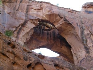
We hurried down to the end of the canyon so we could see Gemini Bridges before the sun went down. We got there with a little bit of daylight left and found ourselves in the bottom of a big box canyon.

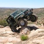
Bob S. and Steve both climbed up in a hole in the rock. They made it down safely and we all breathed a sigh of relief.

Steve had family visiting so he didn't stay to play in the sand. Bob R. also left, and Wayne thought we had all gone so he followed Steve out. That left the rest of us to play on the sand hills as the sun set.

Bob S. and Eric were playing in the sand and both ended up hitting a tree with the sides of their windshield frames. Eric escaped without any damage but Bob S. managed to dent and scrape his frame up pretty well.

We found a hill with particularly deep sand near the far wall. Monica tried it a dozen times, digging herself deep into the sand at the top and throwing sand into her Jeep. It took a lot more momentum to make it, and when she gave it more gas it was an easier hill.

Bob S. came around a corner, then backed up a bit to bend his rear drivers-side shock all the way forward. He had jumped a big sand hill and lost his mount. He got rid of the shock with plans to fix it in the morning.

Bob S. made it up the sand hill minus a shock, then Ladd made it. Eric played and didn't have enough speed, getting buried at the top. The rooster tails of sand were flying into his Jeep, burying everything in sand. It was a mess but it was a blast!

These have to be some of the best sand hills in Moab and they are well worth the trip. The scenery is also amazing. It was a great end to a great day!

between_rocks
big_rock_slab
bob_s_and_steve_climbing_part_1
bob_s_and_steve_climbing_part_2
bob_s_lights_and_dust
bob_s_trail_damage_part_1
bob_s_trail_damage_part_2
bob_s_trail_damage_part_3
canyon_walls
dirt_trail
eric_in_darkness
eric_in_sand_part_1
eric_in_sand_part_2
eric_lights
eric_lit_up
eric_on_the_trail
gemini_bridges_part_1
gemini_bridges_part_2
hole
ladd_and_bob_r
ladd_on_the_trail
monica_on_the_trail
our_dust
rock_hole
sand_hills
steve_climbing
sunset
wayne_on_rocks

Reports from Other Days: 2

Use the arrows or dots to flip through the previews of the other reports for Bull Canyon. Click one of them to read more and see all of the photos from that day.

May 12, 2011

Led by Monica I.
Bull Canyon was our last trail of the day. It wasn’t quite dusk yet but it was getting close. Luckily it wasn’t far to the parking area to go view Gemini Bridges. When we were there last, years ago, you could drive to within a short walk of the bridges….
»
  • 1
  • 2
Join Us!
If you aren’t a Member or Subscriber, you can’t see all of the content on this site. Get membership information to see why this site is best when you join and log in

Information for Subscribers

When you log in you’ll see more information here:

  • Recent Community Forum posts
  • Recent polls
  • Upcoming Events you can attend
  • Links to online users

© 2000-2022 · TrailDamage.com · Terms and Conditions · About · Contact
Trail information is only accurate on the date posted. Trails may have changed or closed since that date. Use this information for historical purposes only.
Contact the Forest Service or Bureau of Land Management for up-to-date trail information.

/* ----------------------------------------- */ /* View slug: reports-other-reports-for-same-trail-slider - start */ /* ----------------------------------------- */ /* place the prev/next controls on the sides */ .td-transition-controls .wpv-filter-next-link, .td-transition-controls .wpv-filter-previous-link { border: none; font-size: 300%; position: absolute; top: 70px; } .td-transition-controls .wpv-filter-previous-link { left: 0; } .td-transition-controls .wpv-filter-next-link { right: 0; } /* center the page selector horizonatally */ .td-transition-controls ul.wpv_pagination_dots { text-align: center; margin-top: 10px; } /* center the page selector horizonatally */ .td-transition-controls ul.wpv_pagination_dots li.wpv_pagination_dots_item, .td-transition-controls .wpv_pagination_dots li a { display: inline-block; float: none; } /* remove the default styles */ .td-transition-controls .wpv_pagination_dots li a { text-decoration: none; border-bottom: none; } .td-slider-container { padding: 0 25px; margin-bottom: 20px; position: relative; width:100%; display:table; } .td-slides { position: relative; } .td-slides-image { float:left; display:table-cell; } .td-slides-image img { border:1px solid #c0c0c0; } .td-slides-content { padding:4px 4px 4px 10px; border-top:1px solid #c0c0c0; border-right:1px solid #c0c0c0; border-bottom:1px solid #c0c0c0; display:table-cell; height:227px; overflow:hidden; } .td-slides-content h3 { margin-top:8px; } .td-slides-leader { font-size:smaller; margin-top:4px; } /* ----------------------------------------- */ /* View slug: reports-other-reports-for-same-trail-slider - end */ /* ----------------------------------------- */
/* ----------------------------------------- */ /* Content Template: Template for a Single Report - start */ /* ----------------------------------------- */ .entry-header { display:none; } .entry-content h1 { margin-top:16px; padding-top:0; } h1 a { color:#222; } h1 a:hover { color:#666; } p.entry-meta { font-size:small; } #report-body-spacer { clear:both; width:100%; height:20px; } #addtoany-bar { margin-bottom:2em; text-align:center; } .category-reports .post-info .author, .post-info .date { display: none; } .addthis_recommended_horizontal { text-align:center !important; } /* ----------------------------------------- */ /* Content Template: Template for a Single Report - end */ /* ----------------------------------------- */ /* ----------------------------------------- */ /* Content Template: Loop item in REPORTS Runners - start */ /* ----------------------------------------- */ #runners-container { width:100%; clear:both; } .runner { border:1px solid #c0c0c0; margin:0 6px 6px 0; float:left; width:49%; height:81px; } .runner-image { float: left; } .runner-image img { margin:2px 10px 0 2px; height:75px; width:75px; } .runner-name { text-transform:uppercase; } .runner-name a { color:#222; } .runner-name a:hover { color:#666; } .runner-vehicle { font-size:small; } @media only screen and (max-width: 768px) { .runner { width:100%; } } /* ----------------------------------------- */ /* Content Template: Loop item in REPORTS Runners - end */ /* ----------------------------------------- */