TrailDamage.com

Photos, videos and information about 4x4 trails in Colorado and Utah

  • Trails
    • Colorado
    • Utah
  • Reports
    • Featured Photos
    • Featured Videos
    • Reports Calendar
  • Members
  • Search
  • Trail Damage Winners
  • FAQ
  • Community
  • Upcoming Events
  • Membership
  • Log In
  • Facebook
  • Instagram
  • RSS
  • Twitter
  • YouTube

Bright Trail 080719

July 19, 2008 by Monica

Bright Trail

Trail Run on July 19, 2008
Report and photos by Monica I., Trail Leader
View trail information for Bright Trail

Jed P.
Green 1998 Jeep Wrangler
Monica I.
Red 2010 Jeep Wrangler Rubicon
Mike S.
Silver 2004 Jeep Wrangler Rubicon
Roger R.
White 2005 Jeep Wrangler Unlimited Rubicon
Mike C.
Red 2012 Jeep Wrangler Unlimited Rubicon
Walt S.
Gray 2018 Jeep Wrangler Unlimited Rubicon

This was the first time we ran this trail, and it was worth it. We were expecting a simple dirt road, but we found a lot more.

We ran Johnny Park Road first, thinking that Bright Trail went all the way through to connect with that trail. It was just a hiking trail at Johnny Park Road, though, so we were out of luck. We finished Johnny Park Road and then headed around to the Bright Trail trailhead instead.

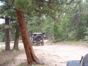
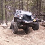
It was easy to find, with good parking at the trailhead gate. The trail itself was fairly mellow, with some nice rocky sections here and there. It was often in the trees, but not always, opening up to some nice views at times.

We stopped at the first shady area, getting out of the sun for a bit. It was hot! We would see the same group of hikers along the trail, and they passed us at this point. We all chatted for a bit, but then continued on.

We decided to run all of 330 first, and then check out the spurs. There was someone camping at the far end of 330, and it looked like a good place. It was sandy and flat.

There were also lots of hiking trailheads along the trail. This could really be a great place to camp and hike all weekend. We didn't see too many people, either.

We saw the hikers just off the trail, along a spur that wasn't numbered. We thought we'd go check it out, and we were glad we did. It suddenly put us at the edge of a big drop-off, and the views were amazing. This would be a fabulous place to camp, and you could bring a whole group of people. We really enjoyed the scenery.

We explored 330C first, and though it had a good camp spot it was pretty uneventful. At one point, Barbie decided she'd had enough and she jumped off of Monica's antenna. Everyone looked for awhile but couldn't find her, but then she was found on top of Monica's Jeep.

We explored 330B, too. It had a nice section of rocks, and where it abruptly ended it looked pretty interesting. The trail continued, but only as a narrow hiking trail. That would be fun to explore.

It wasn't long before we were out again, at the trailhead. This was a nice trail because of the views, and we'd be back again.

big_view
bumpy_on_330B
bumpy_on_330C
bumpy_section
end_of_330
end_of_330B
end_of_330C
first_hiking_trail
first_sight_of_longs_peak
fun_rocks_on_330B
hiking_at_the_end_of_330B
intersection_with_330B
into_the_trees
jed_in_sand
mike_c_in_sand
mike_s_in_sand
monica_at_the_end_of_330B
monica_on_the_trail
nice_climb
open_area
overgrown_on_330C
roger_in_sand
second_hiking_trail
sign_at_end_of_330C
start_of_330C
start_of_the_trail
tippy_on_330B
trailhead_sign
trailhead
view_from_the_overlook_part_1
view_from_the_overlook_part_2
view_from_the_overlook_part_3
view_from_the_overlook_part_4
walt_in_sand

Report from a Different Day

August 14, 2010

Led by Ladd G.
We started the day with Rock Creek, and Bright Trail was our second trail of the day. On the way up to Rock Creek we looked for Taylor Road, and noted it was just south of mile marker 17, and that made it easy to find on the way back….
Join Us!
If you aren’t a Member or Subscriber, you can’t see all of the content on this site. Get membership information to see why this site is best when you join and log in

Information for Subscribers

When you log in you’ll see more information here:

  • Recent Community Forum posts
  • Recent polls
  • Upcoming Events you can attend
  • Links to online users

© 2000-2021 · TrailDamage.com · Terms and Conditions · About · Contact
Trail information is only accurate on the date posted. Trails may have changed or closed since that date. Use this information for historical purposes only.
Contact the Forest Service or Bureau of Land Management for up-to-date trail information.

/* ----------------------------------------- */ /* View slug: reports-other-reports-for-same-trail-slider - start */ /* ----------------------------------------- */ /* place the prev/next controls on the sides */ .td-transition-controls .wpv-filter-next-link, .td-transition-controls .wpv-filter-previous-link { border: none; font-size: 300%; position: absolute; top: 70px; } .td-transition-controls .wpv-filter-previous-link { left: 0; } .td-transition-controls .wpv-filter-next-link { right: 0; } /* center the page selector horizonatally */ .td-transition-controls ul.wpv_pagination_dots { text-align: center; margin-top: 10px; } /* center the page selector horizonatally */ .td-transition-controls ul.wpv_pagination_dots li.wpv_pagination_dots_item, .td-transition-controls .wpv_pagination_dots li a { display: inline-block; float: none; } /* remove the default styles */ .td-transition-controls .wpv_pagination_dots li a { text-decoration: none; border-bottom: none; } .td-slider-container { padding: 0 25px; margin-bottom: 20px; position: relative; width:100%; display:table; } .td-slides { position: relative; } .td-slides-image { float:left; display:table-cell; } .td-slides-image img { border:1px solid #c0c0c0; } .td-slides-content { padding:4px 4px 4px 10px; border-top:1px solid #c0c0c0; border-right:1px solid #c0c0c0; border-bottom:1px solid #c0c0c0; display:table-cell; height:227px; overflow:hidden; } .td-slides-content h3 { margin-top:8px; } .td-slides-leader { font-size:smaller; margin-top:4px; } /* ----------------------------------------- */ /* View slug: reports-other-reports-for-same-trail-slider - end */ /* ----------------------------------------- */
/* ----------------------------------------- */ /* Content Template: Template for a Single Report - start */ /* ----------------------------------------- */ .entry-header { display:none; } .entry-content h1 { margin-top:16px; padding-top:0; } h1 a { color:#222; } h1 a:hover { color:#666; } p.entry-meta { font-size:small; } #report-body-spacer { clear:both; width:100%; height:20px; } #addtoany-bar { margin-bottom:2em; text-align:center; } .category-reports .post-info .author, .post-info .date { display: none; } .addthis_recommended_horizontal { text-align:center !important; } /* ----------------------------------------- */ /* Content Template: Template for a Single Report - end */ /* ----------------------------------------- */ /* ----------------------------------------- */ /* Content Template: Loop item in REPORTS Runners - start */ /* ----------------------------------------- */ #runners-container { width:100%; clear:both; } .runner { border:1px solid #c0c0c0; margin:0 6px 6px 0; float:left; width:49%; height:81px; } .runner-image { float: left; } .runner-image img { margin:2px 10px 0 2px; height:75px; width:75px; } .runner-name { text-transform:uppercase; } .runner-name a { color:#222; } .runner-name a:hover { color:#666; } .runner-vehicle { font-size:small; } @media only screen and (max-width: 768px) { .runner { width:100%; } } /* ----------------------------------------- */ /* Content Template: Loop item in REPORTS Runners - end */ /* ----------------------------------------- */