TrailDamage.com

Photos, videos and information about 4x4 trails in Colorado and Utah

  • Trails
    • Colorado
    • Utah
  • Reports
    • Featured Photos
    • Featured Videos
    • Reports Calendar
  • Members
  • Search
  • Trail Damage Winners
  • FAQ
  • Community
  • Upcoming Events
  • Membership
  • Log In
  • Facebook
  • Instagram
  • RSS
  • Twitter
  • YouTube

Blanca Peak 070825

August 25, 2007 by Matt Kuczborski

Blanca Peak

Trail Run on August 25, 2007
Report and photos by Matt K., Trail Leader
View trail information for Blanca Peak

Matt K.
White 2016 Jeep Wrangler Unlimited Rubicon
Steve B.
Green 2000 Jeep Wrangler

It felt like it was going to be a warm, sunny day while we were at the trailhead off of Highway 150. The weather would cooperate as we worked our way up the mountain. We had been anxious to conquer this trail all summer and we were finally starting it. We aired down and started up the sand and jarring rocks on our way to the obstacles.

We continued on up the trail and met several hikers making their way up the trail as well. We worked our way through the switchbacks and into the forest. We soon made it to Jaws 1 with Steve in the lead.

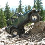
Steve tried going slowly and to the right side of the obstacle and quickly got himself into a very tippy situation. He cautiously backed up and repositioned as Matt spotted him over the obstacle. Matt went next and he took the same line Steve tried and got really tippy. He made it over Jaws 1, though, with a fast-beating heart.

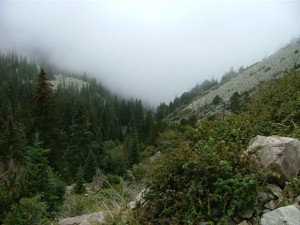
We continued on the trail overlooking some beautiful scenery, looking back over the valley as we came to Jaws 2. We got out and scouted around it to get a good look at it before attempting the treacherous obstacle.

Steve started up first, trying to hug the right side. He started to slide left and felt uncomfortable about it, so he backed off. He was confused and wondering how he was going to get through the obstacle. There was a log on the left side and it was solid with rocks supporting it, so he put his driver's tire on it to see if it would move. The log didn't move so he continued over it with ease.

Matt followed Steve's lines with Steve spotting him over the log and rocks, and he had no problems either. We were both thankful for the log, and we knew it was there to make Jaws 2 safer after the fatal fall of a fellow Jeep enthusiast from the same location.

We continued up to the large rock formations at Jaws 2 1/2. We had stopped there to allow others to winch an ATV from the side of the mountain after an unsuccessful attempt at the obstacle. Thankfully the rider was okay after grabbing onto a tree on his way over the side. We waited for the clean up and watched the two Jeeps ahead of us go through.

After the Jeeps ahead of us had passed, Steve went first and wanted to position his Jeep perfectly in the notch. He worked his Jeep back and forth until he got it lined up just right, hugging the left side as closely as possible. He started up Jaws 2 1/2 but his rear tire wouldn't stick to the rock. It slid down into the notch instead, making him get too tippy. He backed up and attempted it again, trying to avoid the high rock on the passenger side. He ended up getting hung on his right front long control arm on that rock.

We scratched our heads, trying to figure out what his best way over would be. Steve decided he would try to go over it straight, trying not to hang up his differential over the high point on the rock. He tried that line but started sliding closer to the edge. Instead of risking it he decided to winch at that point, and made it over without hitting the bottom of his Jeep.

Matt attempted the same line and made it over a little further until he got hung up on his rear axle. He preferred to winch as well and made it through the obstacle just fine.

We proceeded on up the trail, with the rocks getting larger as we went. We made it through Jaws 3 with great flex and no problems. We continued across the talus ledge and came to Lake Como. It was a beautiful sight, with several hikers and a couple groups of Jeepers setting up camp.

We continued on past the lake to Jaws 4 and had little difficulty tackling that obstacle. We kept going to the end of the trail, and then turned around to go back down Jaws 4 with plans to camp overnight at Lake Como.

We had a great night at the lake. The next day was a pleasant trip back down, with no upcoming traffic other than an occasional hiker who would stop to watch us and take pictures, telling us we were nuts. It felt like a different challenge to go back down, but neither one of us had any issues so it went pretty quickly. We finally arrived at the trailhead, continuing on to Medano Pass. We didn't suffer any trail damage, and it was a great trip.

almost_to_jaws_1
driving_past_lake_como
forest_and_switchbacks
lake_como_camping
matt_down_jaws_1
matt_up_jaws_1
matt_up_jaws_2_part_1
matt_up_jaws_2_part_2
matt_up_jaws_2.5
matt_up_the_switchbacks
plaque_at_jaws_2
steve_down_jaws_2.5
steve_on_a_talus_ledge
steve_up_jaws_1
steve_up_jaws_2
steve_up_jaws_3
steve_up_switchbacks
talus_ledge
two_jeeps

Reports from Other Days: 2

Use the arrows or dots to flip through the previews of the other reports for Blanca Peak. Click one of them to read more and see all of the photos from that day.

August 19, 2006

Led by Monica I.
We had been looking forward to doing Blanca Peak again, and it looked like it was going to be a completely new experience. It was dusty and dry in 2005 but this year it had been raining a lot. The top third of the mountains were covered in thick clouds…
»
  • 1
  • 2
Join Us!
If you aren’t a Member or Subscriber, you can’t see all of the content on this site. Get membership information to see why this site is best when you join and log in

Information for Subscribers

When you log in you’ll see more information here:

  • Recent Community Forum posts
  • Recent polls
  • Upcoming Events you can attend
  • Links to online users

© 2000-2023 · TrailDamage.com · Terms and Conditions · About · Contact
Trail information is only accurate on the date posted. Trails may have changed or closed since that date. Use this information for historical purposes only.
Contact the Forest Service or Bureau of Land Management for up-to-date trail information.

/* ----------------------------------------- */ /* View slug: reports-other-reports-for-same-trail-slider - start */ /* ----------------------------------------- */ /* place the prev/next controls on the sides */ .td-transition-controls .wpv-filter-next-link, .td-transition-controls .wpv-filter-previous-link { border: none; font-size: 300%; position: absolute; top: 70px; } .td-transition-controls .wpv-filter-previous-link { left: 0; } .td-transition-controls .wpv-filter-next-link { right: 0; } /* center the page selector horizonatally */ .td-transition-controls ul.wpv_pagination_dots { text-align: center; margin-top: 10px; } /* center the page selector horizonatally */ .td-transition-controls ul.wpv_pagination_dots li.wpv_pagination_dots_item, .td-transition-controls .wpv_pagination_dots li a { display: inline-block; float: none; } /* remove the default styles */ .td-transition-controls .wpv_pagination_dots li a { text-decoration: none; border-bottom: none; } .td-slider-container { padding: 0 25px; margin-bottom: 20px; position: relative; width:100%; display:table; } .td-slides { position: relative; } .td-slides-image { float:left; display:table-cell; } .td-slides-image img { border:1px solid #c0c0c0; } .td-slides-content { padding:4px 4px 4px 10px; border-top:1px solid #c0c0c0; border-right:1px solid #c0c0c0; border-bottom:1px solid #c0c0c0; display:table-cell; height:227px; overflow:hidden; } .td-slides-content h3 { margin-top:8px; } .td-slides-leader { font-size:smaller; margin-top:4px; } /* ----------------------------------------- */ /* View slug: reports-other-reports-for-same-trail-slider - end */ /* ----------------------------------------- */
/* ----------------------------------------- */ /* Content Template: Template for a Single Report - start */ /* ----------------------------------------- */ .entry-header { display:none; } .entry-content h1 { margin-top:16px; padding-top:0; } h1 a { color:#222; } h1 a:hover { color:#666; } p.entry-meta { font-size:small; } #report-body-spacer { clear:both; width:100%; height:20px; } #addtoany-bar { margin-bottom:2em; text-align:center; } .category-reports .post-info .author, .post-info .date { display: none; } .addthis_recommended_horizontal { text-align:center !important; } /* ----------------------------------------- */ /* Content Template: Template for a Single Report - end */ /* ----------------------------------------- */ /* ----------------------------------------- */ /* Content Template: Loop item in REPORTS Runners - start */ /* ----------------------------------------- */ #runners-container { width:100%; clear:both; } .runner { border:1px solid #c0c0c0; margin:0 6px 6px 0; float:left; width:49%; height:81px; } .runner-image { float: left; } .runner-image img { margin:2px 10px 0 2px; height:75px; width:75px; } .runner-name { text-transform:uppercase; } .runner-name a { color:#222; } .runner-name a:hover { color:#666; } .runner-vehicle { font-size:small; } @media only screen and (max-width: 768px) { .runner { width:100%; } } /* ----------------------------------------- */ /* Content Template: Loop item in REPORTS Runners - end */ /* ----------------------------------------- */