TrailDamage.com

Photos, videos and information about 4x4 trails in Colorado and Utah

  • Trails
    • Colorado
    • Utah
  • Reports
    • Featured Photos
    • Featured Videos
    • Reports Calendar
  • Members
  • Search
  • Trail Damage Winners
  • FAQ
  • Community
  • Upcoming Events
  • Membership
  • Log In
  • Facebook
  • Instagram
  • RSS
  • Twitter
  • YouTube

Bill Moore Lake 180721

July 21, 2018 by Monica

Bill Moore Lake

Trail Run on July 21, 2018
Report and photos by Monica I., Trail Leader
View trail information for Bill Moore Lake

Mike S.
Silver 2004 Jeep Wrangler Rubicon
Matt K.
White 2016 Jeep Wrangler Unlimited Rubicon
Sean G.
Brown 2017 Toyota Tacoma

After a great time on the rocks on Red Elephant Hill and Mill Creek, we ran up the top part of Bill Moore Lake to meet Sean at the end.  We were actually ahead of schedule, with only two of us running the morning's trails.  The sun was shining and there were flowers everywhere.

We laughed about that video on the curve where Red Elephant Hill meets Bill Moore Lake, from the first official TrailDamage.com run.  Things have changed, and we couldn't imagine actually getting out to get video at that spot.  The curve was much more eroded than it was back then, but it was still an easy section.

There was a new sign marking a bypass around the loose, braided hill where the snow stays for the longest.  We didn't see any snow, and the sign didn't make much sense.  It pointed us to the High Clearance 4x4 Route, and the other way was the High Clearance Bypass.  Was the bypass also for high-clearance vehicles, or was it bypassing the need for high clearance?  We'd take the bypass on the way back so we could find out.  On the way up, we took the usual hill and had our usual good time on it.

We were cruising along the hill when we met Sean coming in the other direction in his truck.  We were glad we didn't miss him.  He backed up just a little bit to get to the place where the mud pit used to be, and we all got out to say our hellos and remember how things used to be.  That section of the trail is nothing like it was, though the big slab of rock in the middle that used to be just a chunky section is still there for us to play on, much bigger than it used to be.  It had been a long, long time since Sean had been on the trail with us, and it was really nice to see him again.

Mike got on it and tried a few angles, but it was just too steep and sharp on the side for him to get over it.  Still, it was a fun try.  Matt got on it next, and even he barely cleared it in spots.  It's a big rock, but Matt got up on top of it.  It's a bit of a silly obstacle because you can just drive around it, but it's still a blast.

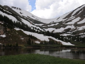
Sean turned around and we all headed over to the lake.  That's where the people were.  We hadn't seen many people at all, but the parking area had quite a few cars and someone camping in a tent right next to the walking path to the lake.  We parked and walked out to the lake, but the rain was starting and it was getting pretty chilly.  We only spent a few minutes near the water before turning around to head back to the Jeeps.

Mike put his Jeep top and windows in, and then it rained the rest of the day.  Matt hadn't been on the Poser Rock, so he worked his way through cars parked at the base of it to get up on it.  There were lots of rocks stacked at the bottom, so anyone could have gotten on it.  His passenger tire was on a point near the top, and he climbed way up to get up on his bumper.  It's always such an awesome picture.

Mike wasn't going to get on the rock because he'd been on it before, but he changed his mind and drove up on it before we left.  He stopped before driving off the other side, thankfully, and he also climbed up to his bumper.  

Sean wasn't up for smacking his truck bumper on a rock, so he skipped Poser Rock.  We started heading back down.  When we got to the bypass, we took that and found a loop that went down the hill and back up.  It didn't have any obstacles, but it wasn't much easier than the other hill we were bypassing.  The regular hill was much better.

When we got to the shortcut that goes back to Red Elephant Hill, we took it so we could see if any of the other spurs were open.  They weren't, so we turned around at the intersection and headed back down.  We turned to go to the Empire Motel 6, and found that cabin in much better shape than the Empire Hilton.  It was clean and very nice, and we could see sleeping there in a pinch.  It even had a really nice fire pit for when the fire ban is lifted.

We even took the Miller Creek spur that we'd never taken before (at least not that we could remember), to find a slightly tippy trip through the trees to a weird ending.  Everything was slanted, and we all found our own place to turn around.  It probably wasn't worth doing that spur again.

We cruised down the trail, and Sean took the big switchback while Mike and Matt went down the Chute.  It seemed like it didn't have as many big rocks in it, but it was still a nice descent.  We reconnected at the intersection of the two options and headed down to the trailhead.  There was a kiosk there that had been put up since we were there last with information about restoration efforts.  It would have been nice to see a kiosk with more historical information about mining in the area but we were happy to see something there.

We usually air up there, but we headed over to Mad Creek instead to get a new trail under our belts.  It was sprinkling, but the sky looked like it was about to get serious about the rain.

P1020642
P1020643
P1020644
P1020645
P1020646
P1020647
P1020648
P1020649
P1020650
P1020651
P1020652
P1020653
P1020654
P1020655
P1020656
P1020657
P1020658
P1020659
P1020660
P1020661
P1020662
P1020663
P1020664
P1020665
P1020666
P1020667
P1020668
P1020669
P1020670
P1020671
P1020672
P1020674
P1020675
P1020676
P1020677
P1020678
P1020679
P1020680
P1020681
P1020682
P1020683
P1020685
P1020686
P1020687
P1020688
P1020689
P1020690
P1020691
P1020692
P1020693
P1020694
P1020695
P1020696
P1020697
P1020698
P1020699
P1020700
P1020701
P1020703
P1020704
P1020705
P1020707
P1020708
P1020709
P1020711
P1020712
P1020713
P1020714
P1020715
P1020716
P1020717
P1020718
P1020719
P1020720
P1020721
P1020722
P1020723
P1020724
P1020725
P1020726
P1020727
P1020728
P1020729
P1020730
P1020731
P1020733
P1020734
P1020735
P1020736
P1020737
P1020738
P1020739
P1020740
P1020741
P1020742
P1020743
P1020746
P1020747
P1020748
P1020749
P1020750
P1020751
P1020754
P1020755
P1020756
P1020757
P1020758
P1020759
P1020761
P1020762
P1020763
P1020764
P1020765
P1020766
P1020767
P1020769
P1020770
P1020772
P1020774
P1020775
P1020776
P1020777
P1020778
P1020780
P1020781
P1020782
P1020783
P1020784
P1020785
P1020786
P1020788
P1020789
P1020790
P1020791
P1020792
P1020795
P1020796
P1020797
P1020798
P1020799
P1020800
P1020801
P1020802
P1020803
P1020804
P1020805
P1020806
P1020807
P1020808
P1020809
P1020810
P1020811
P1020813
P1020814
P1020815
P1020817
P1020818
P1020819
P1020820
P1020821
P1020822
P1020823
P1020825
P1020826
P1020827
P1020828
P1020829
P1020830
P1020831
P1020832
P1020833
P1020834
P1020835
P1020836
P1020838
P1020839
P1020841
P1020843
P1020844
P1020846
P1020847
P1020848
P1020849
P1020850

Reports from Other Days: 9

Use the arrows or dots to flip through the previews of the other reports for Bill Moore Lake. Click one of them to read more and see all of the photos from that day.

August 13, 2011

Led by Monica I.
For some of us, it had been a long time since we had been on Bill Moore Lake. For others, it was their first time on the trail. We were all really looking forward to it so we headed up without stopping for a break. We didn’t even stop at…
« »
  • 1
  • 2
  • 3
  • 4
  • 5
  • 6
  • 7
  • 8
  • 9
Join Us!
If you aren’t a Member or Subscriber, you can’t see all of the content on this site. Get membership information to see why this site is best when you join and log in

Information for Subscribers

When you log in you’ll see more information here:

  • Recent Community Forum posts
  • Recent polls
  • Upcoming Events you can attend
  • Links to online users

© 2000-2021 · TrailDamage.com · Terms and Conditions · About · Contact
Trail information is only accurate on the date posted. Trails may have changed or closed since that date. Use this information for historical purposes only.
Contact the Forest Service or Bureau of Land Management for up-to-date trail information.

/* ----------------------------------------- */ /* View slug: reports-other-reports-for-same-trail-slider - start */ /* ----------------------------------------- */ /* place the prev/next controls on the sides */ .td-transition-controls .wpv-filter-next-link, .td-transition-controls .wpv-filter-previous-link { border: none; font-size: 300%; position: absolute; top: 70px; } .td-transition-controls .wpv-filter-previous-link { left: 0; } .td-transition-controls .wpv-filter-next-link { right: 0; } /* center the page selector horizonatally */ .td-transition-controls ul.wpv_pagination_dots { text-align: center; margin-top: 10px; } /* center the page selector horizonatally */ .td-transition-controls ul.wpv_pagination_dots li.wpv_pagination_dots_item, .td-transition-controls .wpv_pagination_dots li a { display: inline-block; float: none; } /* remove the default styles */ .td-transition-controls .wpv_pagination_dots li a { text-decoration: none; border-bottom: none; } .td-slider-container { padding: 0 25px; margin-bottom: 20px; position: relative; width:100%; display:table; } .td-slides { position: relative; } .td-slides-image { float:left; display:table-cell; } .td-slides-image img { border:1px solid #c0c0c0; } .td-slides-content { padding:4px 4px 4px 10px; border-top:1px solid #c0c0c0; border-right:1px solid #c0c0c0; border-bottom:1px solid #c0c0c0; display:table-cell; height:227px; overflow:hidden; } .td-slides-content h3 { margin-top:8px; } .td-slides-leader { font-size:smaller; margin-top:4px; } /* ----------------------------------------- */ /* View slug: reports-other-reports-for-same-trail-slider - end */ /* ----------------------------------------- */
/* ----------------------------------------- */ /* Content Template: Template for a Single Report - start */ /* ----------------------------------------- */ .entry-header { display:none; } .entry-content h1 { margin-top:16px; padding-top:0; } h1 a { color:#222; } h1 a:hover { color:#666; } p.entry-meta { font-size:small; } #report-body-spacer { clear:both; width:100%; height:20px; } #addtoany-bar { margin-bottom:2em; text-align:center; } .category-reports .post-info .author, .post-info .date { display: none; } .addthis_recommended_horizontal { text-align:center !important; } /* ----------------------------------------- */ /* Content Template: Template for a Single Report - end */ /* ----------------------------------------- */ /* ----------------------------------------- */ /* Content Template: Loop item in REPORTS Runners - start */ /* ----------------------------------------- */ #runners-container { width:100%; clear:both; } .runner { border:1px solid #c0c0c0; margin:0 6px 6px 0; float:left; width:49%; height:81px; } .runner-image { float: left; } .runner-image img { margin:2px 10px 0 2px; height:75px; width:75px; } .runner-name { text-transform:uppercase; } .runner-name a { color:#222; } .runner-name a:hover { color:#666; } .runner-vehicle { font-size:small; } @media only screen and (max-width: 768px) { .runner { width:100%; } } /* ----------------------------------------- */ /* Content Template: Loop item in REPORTS Runners - end */ /* ----------------------------------------- */