TrailDamage.com

Photos, videos and information about 4x4 trails in Colorado and Utah

  • Trails
    • Colorado
    • Utah
  • Reports
    • Featured Photos
    • Featured Videos
    • Reports Calendar
  • Members
  • Search
  • Trail Damage Winners
  • FAQ
  • Community
  • Upcoming Events
  • Membership
  • Log In
  • Facebook
  • Instagram
  • RSS
  • Twitter
  • YouTube

Beaver Creek Road 080913

September 13, 2008 by Monica

Beaver Creek Road

Trail Run on September 13, 2008
Report and photos by Monica I., Trail Leader
View trail information for Beaver Creek Road

Rich M.
Red 2006 Jeep Commander
Mike S.
Silver 2004 Jeep Wrangler Rubicon
Ladd G.
Green 2003 Jeep Wrangler Rubicon
Steve B.
Green 2000 Jeep Wrangler
Matt K.
White 2016 Jeep Wrangler Unlimited Rubicon
Mark F.
Blue 2002 Jeep Wrangler
Mark U.
Red 1989 Jeep Wrangler
Walt S.
Gray 2022 Jeep Wrangler Unlimited Rubicon 392
Monica I.
Red 2010 Jeep Wrangler Rubicon
Ryan S.
Red 1999 Jeep Wrangler

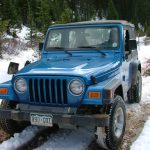
A lot of the people in the group had wondered where this trail went. We always saw it on the way to Webster Pass, but no one had ever explored it. We were looking forward to the adventure.

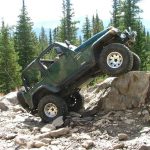
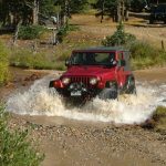
The lake is private, which is unfortunate. It's definitely in a pretty setting. We crossed a nice bridge and went through a small residential area, and then we were climbing up a rocky hill. The rocks were pretty fun, and we hoped for even more of the same as the trail progressed.

When we got to the intersection, the fun rocks stopped. The rest of the trail was pretty mellow. In some ways, swaying back and forth through sandy and muddy potholes is relaxing, and it mellowed us all out.

We saw that there were signs everywhere in preparation for a foot race. At least we hoped that they weren't left over from a race that had already finished. We followed the signs and took the left fork first.

There were a few scenic beaver ponds in the valley we traveled through as we followed Beaver Creek. Otherwise, the scenery was nothing compared to Hall Valley or Webster Pass. When we came to the intersection with the spur that takes you to Lininger Lake, the race signs told runners to take that route. It must have finished at the lake, or the future race would.

We continued on, however, and the trail just ended. We turned around and headed back out without leaving our vehicles. What was this fork for?

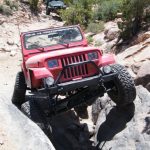
Back at the intersection, we took the other fork. Though there was a mellow hill climb with a couple of rocks in it, this side was also pretty tame. It went through trees and never left them, and then it just ended at a large turnaround and parking area.

This is a weird trail! It doesn't go anywhere (did it ever go anywhere?) and there isn't much scenery other than trees and a few hills. We got out to stretch our legs, chat and snack. Steve was hearing something banging on his Jeep but he couldn't find anything, so he just hoped for the best for the rest of the day.

It wasn't long before we continued on and we were soon back out at the trailhead. We probably won't do this trail very often, but we were glad to finally find out what was back there. Mike and Mark F. left us and headed back to town, and the rest of the group headed to do Guanella Pass and see what else we could find there.

beaver_pond_part_1
beaver_pond_part_2
blue_sky
bumpy
curve_through_aspens
early_bridge
forest_service_sign_1
forest_service_sign_2
into_the_trees
marsh
meadow
north_fork
open_area
private_lake_at_the_trailhead
puddles
south_platte_river
start_of_the_trail
trailhead_sign
Join Us!
If you aren’t a Member or Subscriber, you can’t see all of the content on this site. Get membership information to see why this site is best when you join and log in

Information for Subscribers

When you log in you’ll see more information here:

  • Recent Community Forum posts
  • Recent polls
  • Upcoming Events you can attend
  • Links to online users

© 2000-2023 · TrailDamage.com · Terms and Conditions · About · Contact
Trail information is only accurate on the date posted. Trails may have changed or closed since that date. Use this information for historical purposes only.
Contact the Forest Service or Bureau of Land Management for up-to-date trail information.

/* ----------------------------------------- */ /* View slug: reports-other-reports-for-same-trail-slider - start */ /* ----------------------------------------- */ /* place the prev/next controls on the sides */ .td-transition-controls .wpv-filter-next-link, .td-transition-controls .wpv-filter-previous-link { border: none; font-size: 300%; position: absolute; top: 70px; } .td-transition-controls .wpv-filter-previous-link { left: 0; } .td-transition-controls .wpv-filter-next-link { right: 0; } /* center the page selector horizonatally */ .td-transition-controls ul.wpv_pagination_dots { text-align: center; margin-top: 10px; } /* center the page selector horizonatally */ .td-transition-controls ul.wpv_pagination_dots li.wpv_pagination_dots_item, .td-transition-controls .wpv_pagination_dots li a { display: inline-block; float: none; } /* remove the default styles */ .td-transition-controls .wpv_pagination_dots li a { text-decoration: none; border-bottom: none; } .td-slider-container { padding: 0 25px; margin-bottom: 20px; position: relative; width:100%; display:table; } .td-slides { position: relative; } .td-slides-image { float:left; display:table-cell; } .td-slides-image img { border:1px solid #c0c0c0; } .td-slides-content { padding:4px 4px 4px 10px; border-top:1px solid #c0c0c0; border-right:1px solid #c0c0c0; border-bottom:1px solid #c0c0c0; display:table-cell; height:227px; overflow:hidden; } .td-slides-content h3 { margin-top:8px; } .td-slides-leader { font-size:smaller; margin-top:4px; } /* ----------------------------------------- */ /* View slug: reports-other-reports-for-same-trail-slider - end */ /* ----------------------------------------- */
/* ----------------------------------------- */ /* Content Template: Template for a Single Report - start */ /* ----------------------------------------- */ .entry-header { display:none; } .entry-content h1 { margin-top:16px; padding-top:0; } h1 a { color:#222; } h1 a:hover { color:#666; } p.entry-meta { font-size:small; } #report-body-spacer { clear:both; width:100%; height:20px; } #addtoany-bar { margin-bottom:2em; text-align:center; } .category-reports .post-info .author, .post-info .date { display: none; } .addthis_recommended_horizontal { text-align:center !important; } /* ----------------------------------------- */ /* Content Template: Template for a Single Report - end */ /* ----------------------------------------- */ /* ----------------------------------------- */ /* Content Template: Loop item in REPORTS Runners - start */ /* ----------------------------------------- */ #runners-container { width:100%; clear:both; } .runner { border:1px solid #c0c0c0; margin:0 6px 6px 0; float:left; width:49%; height:81px; } .runner-image { float: left; } .runner-image img { margin:2px 10px 0 2px; height:75px; width:75px; } .runner-name { text-transform:uppercase; } .runner-name a { color:#222; } .runner-name a:hover { color:#666; } .runner-vehicle { font-size:small; } @media only screen and (max-width: 768px) { .runner { width:100%; } } /* ----------------------------------------- */ /* Content Template: Loop item in REPORTS Runners - end */ /* ----------------------------------------- */