TrailDamage.com

Photos, videos and information about 4x4 trails in Colorado and Utah

  • Trails
    • Colorado
    • Utah
  • Reports
    • Featured Photos
    • Featured Videos
    • Reports Calendar
  • Members
  • Search
  • Trail Damage Winners
  • FAQ
  • Community
  • Upcoming Events
  • Membership
  • Log In
  • Facebook
  • Instagram
  • RSS
  • Twitter
  • YouTube

Badger Creek 061007

October 7, 2006 by Monica

Badger Creek

Trail Run on October 7, 2006
Report and photos by Monica I., Trail Leader
View trail information for Badger Creek

Dane R.
Silver 2007 Jeep Wrangler Rubicon
Monica I.
Red 2010 Jeep Wrangler Rubicon
Mark G.
Green 1993 Jeep Wrangler
Mike V.
Blue 2000 Jeep Cherokee
Mike S.
Silver 2004 Jeep Wrangler Rubicon
Jeff L.
Silver 2005 Jeep Wrangler Unlimited Rubicon
Cheryl W.
Orange 2006 Jeep Wrangler Unlimited Rubicon

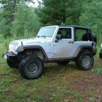
We had really been looking forward to this trip. We were going to find and explore two new trails with very little information to guide us. The first trail was called "Left Fender" and we had read a bit about the obstacle and how it is difficult to do without messing up your left fender. We were ready to check it out.

We found the trailhead easily enough, and there were a few people on dirtbikes at the trailhead when we got there. They said that we had found the right trail and that we probably couldn't get any further than the creek just a few miles in. We were hoping to prove them wrong, so we started up.

The trail was really mellow. Actually, the hardest part was the bumpy dirt road on the way to the trailhead, and even that wasn't difficult. The scenery would have been better but there were almost constantly powerlines above us.

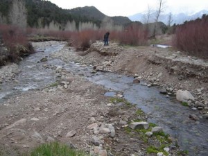
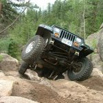
The trail went up big hills and then down them, and finally we got to the creek below us. The trail curved around and we saw where it continued. We got out to check it out.

The trail was basically gone. The creek had washed it away. The trail ended at a five-foot drop into the shallow creek. The edges were very loose. If it was solid dirt it might be something we could climb up and down, but this wasn't going to work out.

We had lunch and talked about it, but there really weren't any options. It was obvious why there was such a well-defined loop here in the trail. It had been this way awhile.

We saw an illegal trail through the brush, but otherwise it looked like people were behaving themselves. We walked down and across the creek, then explored the other side. A sign for Badger Creek was just over the other side, and we found a well-used trail over there. It looked like you could get here from the other side.

We'll go explore it soon and figure out how to get to the other half. That's where the Left Fender obstacle is. We'll have to save it for later.

airing_down_part_1
airing_down_part_2
around_a_corner
badger_creek_part_1
badger_creek_part_2
badger_creek_sign_part_1
badger_creek_sign_part_2
blue_sky
broken_trail_part_1
broken_trail_part_2
broken_trail_part_3
bumps
cheryl_parked
climbing
dane_parked
down_a_hill
end_of_other_trail
exploring_part_1
exploring_part_2
fourteener
lunch_part_1
lunch_part_2
mellow_trail
mountain_view
old_trail
rock_quarry_at_the_trailhead_part_1
rock_quarry_at_the_trailhead_part_2
rock_quarry_at_the_trailhead_part_3
roller_coaster
start_of_the_trail
trail_in_the_distance
trail_leading_to_broken_trail
turn_left_before_these_signs
uphill_curve

Report from a Different Day

April 21, 2007

Led by Mike S.
We had been anxious to get back to Badger Creek since we first saw the trail in October 2006. When we got to the creek we saw that the trail was broken in half, and we could see the rest of the trail on the other side. This time, we…
Join Us!
If you aren’t a Member or Subscriber, you can’t see all of the content on this site. Get membership information to see why this site is best when you join and log in

Information for Subscribers

When you log in you’ll see more information here:

  • Recent Community Forum posts
  • Recent polls
  • Upcoming Events you can attend
  • Links to online users

© 2000-2021 · TrailDamage.com · Terms and Conditions · About · Contact
Trail information is only accurate on the date posted. Trails may have changed or closed since that date. Use this information for historical purposes only.
Contact the Forest Service or Bureau of Land Management for up-to-date trail information.

/* ----------------------------------------- */ /* View slug: reports-other-reports-for-same-trail-slider - start */ /* ----------------------------------------- */ /* place the prev/next controls on the sides */ .td-transition-controls .wpv-filter-next-link, .td-transition-controls .wpv-filter-previous-link { border: none; font-size: 300%; position: absolute; top: 70px; } .td-transition-controls .wpv-filter-previous-link { left: 0; } .td-transition-controls .wpv-filter-next-link { right: 0; } /* center the page selector horizonatally */ .td-transition-controls ul.wpv_pagination_dots { text-align: center; margin-top: 10px; } /* center the page selector horizonatally */ .td-transition-controls ul.wpv_pagination_dots li.wpv_pagination_dots_item, .td-transition-controls .wpv_pagination_dots li a { display: inline-block; float: none; } /* remove the default styles */ .td-transition-controls .wpv_pagination_dots li a { text-decoration: none; border-bottom: none; } .td-slider-container { padding: 0 25px; margin-bottom: 20px; position: relative; width:100%; display:table; } .td-slides { position: relative; } .td-slides-image { float:left; display:table-cell; } .td-slides-image img { border:1px solid #c0c0c0; } .td-slides-content { padding:4px 4px 4px 10px; border-top:1px solid #c0c0c0; border-right:1px solid #c0c0c0; border-bottom:1px solid #c0c0c0; display:table-cell; height:227px; overflow:hidden; } .td-slides-content h3 { margin-top:8px; } .td-slides-leader { font-size:smaller; margin-top:4px; } /* ----------------------------------------- */ /* View slug: reports-other-reports-for-same-trail-slider - end */ /* ----------------------------------------- */
/* ----------------------------------------- */ /* Content Template: Template for a Single Report - start */ /* ----------------------------------------- */ .entry-header { display:none; } .entry-content h1 { margin-top:16px; padding-top:0; } h1 a { color:#222; } h1 a:hover { color:#666; } p.entry-meta { font-size:small; } #report-body-spacer { clear:both; width:100%; height:20px; } #addtoany-bar { margin-bottom:2em; text-align:center; } .category-reports .post-info .author, .post-info .date { display: none; } .addthis_recommended_horizontal { text-align:center !important; } /* ----------------------------------------- */ /* Content Template: Template for a Single Report - end */ /* ----------------------------------------- */ /* ----------------------------------------- */ /* Content Template: Loop item in REPORTS Runners - start */ /* ----------------------------------------- */ #runners-container { width:100%; clear:both; } .runner { border:1px solid #c0c0c0; margin:0 6px 6px 0; float:left; width:49%; height:81px; } .runner-image { float: left; } .runner-image img { margin:2px 10px 0 2px; height:75px; width:75px; } .runner-name { text-transform:uppercase; } .runner-name a { color:#222; } .runner-name a:hover { color:#666; } .runner-vehicle { font-size:small; } @media only screen and (max-width: 768px) { .runner { width:100%; } } /* ----------------------------------------- */ /* Content Template: Loop item in REPORTS Runners - end */ /* ----------------------------------------- */