TrailDamage.com

Photos, videos and information about 4x4 trails in Colorado and Utah

  • Trails
    • Colorado
    • Utah
  • Reports
    • Featured Photos
    • Featured Videos
    • Reports Calendar
  • Members
  • Search
  • Trail Damage Winners
  • FAQ
  • Community
  • Upcoming Events
  • Membership
  • Log In
  • Facebook
  • Instagram
  • RSS
  • Twitter
  • YouTube

Twin Cone 050625

June 25, 2005 by Monica

Twin Cone

Trail Run on June 25, 2005
Report and photos by Monica I., Trail Leader
View trail information for Twin Cone

Ladd G.
Green 2003 Jeep Wrangler Rubicon
Carlos S.
Gray 1990 Jeep Cherokee
Kendall C.
Blue 1988 Suzuki Samurai
Alanna B.
Blue 2001 Jeep Cherokee
Walt S.
Gray 2022 Jeep Wrangler Unlimited Rubicon 392
Bob S.
Green 1997 Jeep Wrangler
Micheal S.
Maroon 1988 Jeep Cherokee
Cheryl W.
Orange 2006 Jeep Wrangler Unlimited Rubicon
Jim D.
Silver 2003 Jeep Wrangler
Mike S.
Silver 2002 Jeep Wrangler
Monica I.
Red 2010 Jeep Wrangler Rubicon

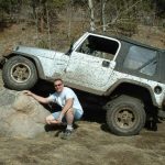
We had a great group of people and a beautiful day on the trail. The trail itself was the driest we'd ever seen, but there were still plenty of mud puddles to go through. Alanna got turned back at the big hill again -- this time in a new Cherokee -- but she rode up to the top as a passenger.

We had a lot of catching up to do and got a late start leaving from Conifer. We aired down at the trailhead and got started. The mud puddles that you usually find at the beginning of the trail were either gone or very shallow. Even the long trench of water that always seems to be there was down to a tiny puddle.

We did have one puddle that was small but surprisingly deep in the middle, and nearly everyone dipped their front bumper in the muddy water just a little.

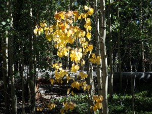
It wasn't too long at all before we got to the Overlook, passing only one camper on the way up the switchbacks. Everyone got out and almost everyone crawled out to the rocks at the very edge. It was pretty hazy over South Park but you could still see for a long way. A few people even climbed out to the section with the lone tree to take some pictures. It's a long way down from there!

We all enjoyed the views for a bit and then we were off again. We worked our way up the trail to the first set of rocks. When we got there everyone drove right through the rocky section without any troubles, though Kendall hit one of his side steps and bent it a bit.

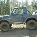
Then we got to the next rocky area where you have two options. You can either go on the left side where you are high up on rocks and usually very tippy, or you can take the much easier line through the smaller rocks to the right. Everyone took the tippy line on the left and no one had any problems. It gets tippy there but the only times we had any scares were on the way down much later.

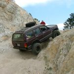
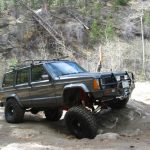
It started to get truly challenging when we got to the next set of rocks. This is where there is the bypass on the right (you shouldn't take this bypass, it isn't an approved route) and the wide section of rocks on the left. If you go up this leftmost section on the far right side it is the most challenging, with a thin rock that sticks out enough to high center most vehicles on 33" tires.

Ladd went first, finding the right line and going right through it. Monica followed his line and also didn't have any problems. Bob managed to straddle the rock that sticks out, clearing it just fine on his 35" tires.

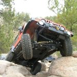
Walt decided to take the line on the left to avoid high centering his Blazer and had no issues at all, and then Cheryl and Carlos drove right through the very rocky section like it was paved.

Micheal went next and had the right line through the rocky section, but then he slipped off the thin rock. He worked at it for a bit but after you slip off that rock it can be very difficult to get going again. He ended up backing down again and going through it in the middle.

Mike, Alanna and Jim went next, both taking the difficult line and driving through it without any issues. Alanna was especially happy because she had a lot of problems the year before in her former Cherokee (XJ). It was very muddy when we ran this trail in 2004 and it made it much more difficult.

Kendall had his Dodge with him and the long wheelbase made the obstacle pretty easy. He made it through the tough section only to hit both center caps on his passenger side on the same rock. They both got pretty mangled.

While we were all working our way through the obstacle there was another large group of vehicles coming down. They were all at the big hill and unfortunately because the part of this trail that is not the approved way is not marked they all took that line.

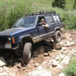
We all managed to get to the base of the big hill to let them pass. Though it was rocky and very loose it was also dry so we all worked our way up it. No one really had an easy time climbing but no one had any real issues until it was Kendall's turn.

It seemed like he was going to make it up just fine, but then he blew a rear tire. He had to carefully back down to change it.

Then it was Alanna's turn. She had worked on this hill for awhile in 2004 with her former XJ so she was ready to tackle it in her new XJ. She worked at it for awhile but couldn't make it too far up the first part. She decided to park it down at the base of the hill and ride up with other people instead.

At this point it rained a little so we all put on tops and windows if we had them. Another large group came down at this point and took the bypass that was made by others and not approved. It is not marked so it is an easy mistake to make, but note that the true trail is the very rocky one at the far right as you look up at it from the bottom.

We all started up again and decided that we could all fit at the top instead of taking two separate groups up. We probably should have split in two, because it became very difficult to fit us all up there and to turn around when we were leaving.

It was windy and chilly and there was lots of rain in the mountains around us, but we got lucky and it didn't rain on us while we were up there. The views were beautiful of South Park in the haze.

Red Cone and Webster Pass still had lots of snow on them, so it will be awhile yet before they are ready to be crossed. We could see Guanella Pass and it looked very dry.

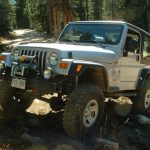
We worked our way down and it was fairly uneventful until we got to the tippy section. The trail was a little muddy before getting to it so our tires were wet, making it very slick.

Bob managed to get himself in a bad position, sliding sideways off the rock. He just needed a little help holding his Jeep on the rocks to get down. Micheal had a rear tire very far in the air on his way through it, too. There was lots of slipping and sliding and moments of panic, but most people took the tippy line anyway and enjoyed every minute of it.

We worked our way down and off the trail, then a lot of us went to Sweet Fanny Adams in Bailey for dinner. It was a great day!

airing_down
alanna_in_a_puddle_part_1
alanna_in_a_puddle_part_2
alanna_in_rocks_part_1
alanna_in_rocks_part_2
alanna_obstacle_part_1
alanna_obstacle_part_2
alanna_obstacle_part_3
alanna_obstacle_part_4
alanna_obstacle_part_5
alanna_on_the_trail
alanna_parked
alanna_tippy_part_1
alanna_tippy_part_2
at_the_top
big_hill_part_1
big_hill_part_2
bob_crazy
bob_in_rocks
bob_muddy
bob_obstacle_part_1
bob_obstacle_part_2
bob_tippy_part_1
bob_tippy_part_2
bob_tippy_part_3
carlos_flex
carlos_in_rocks_part_1
carlos_in_rocks_part_2
carlos_in_rocks_part_3
carlos_obstacle_part_1
carlos_obstacle_part_2
carlos_on_the_trail
carlos_tippy_part_1
carlos_tippy_part_2
carlos_up_the_big_hill
cheryl_at_the_overlook
cheryl_in_rocks_part_1
cheryl_in_rocks_part_2
cheryl_obstacle_part_1
cheryl_obstacle_part_2
cheryl_obstacle_part_3
cheryl_obstacle_part_4
cheryl_tippy_part_1
cheryl_tippy_part_2
cheryl_up_the_big_hill
deep_mud_puddle
everyone_on_the_trail
hanging_out
jim_in_rocks
jim_obstacle
jim_on_the_trail
jim_tippy_part_1
jim_tippy_part_2
jim_tippy_part_3
jim_up_the_big_hill_part_1
jim_up_the_big_hill_part_2
kendall_in_rocks_part_1
kendall_in_rocks_part_2
kendall_in_rocks_part_3
kendall_obstacle_part_1
kendall_obstacle_part_2
kendall_on_the_trail
kendall_tippy_part_1
kendall_tippy_part_2
kendall_tippy_part_3
kendall_tippy_part_4
kendall_tippy_part_5
kendall_trail_damage_part_1
kendall_trail_damage_part_2
kendall_up_the_big_hill
ladd_obstacle_part_1
ladd_obstacle_part_2
ladd_obstacle_part_3
ladd_obstacle_part_4
ladd
lunch
micheal_in_rocks_part_1
micheal_in_rocks_part_2
micheal_obstacle_part_1
micheal_obstacle_part_2
micheal_obstacle_part_3
micheal_obstacle_part_4
micheal_obstacle_part_5
micheal_parked
micheal_tippy_part_1
micheal_tippy_part_2
micheal_up_the_big_hill
mike_in_rocks_part_1
mike_in_rocks_part_2
mike_obstacle_part_1
mike_obstacle_part_2
mike_tippy_part_1
mike_tippy_part_2
mike_up_the_big_hill
monica_in_a_puddle_part_1
monica_in_a_puddle_part_2
monica_in_rocks_part_1
monica_in_rocks_part_2
monica_in_rocks_part_3
monica_obstacle_part_1
monica_obstacle_part_2
monica_obstacle_part_3
monica_obstacle_part_4
monica_on_the_trail
monica_tippy
monica_up_the_big_hill
on_the_trail
overlook_pose
overlook
snowy_mountains
south_twin_cone
tree_on_the_edge
view_from_the_top
view_of_south_park
walt_in_rocks
walt_obstacle
walt_on_the_trail
walt_parked
walt_tippy_part_1
walt_tippy_part_2
walt_up_the_big_hill
weather_in_the_distance

Reports from Other Days: 6

Use the arrows or dots to flip through the previews of the other reports for Twin Cone. Click one of them to read more and see all of the photos from that day.

August 27, 2017

Led by Monica I.
This had to be the first time we went to a trail with some regret. We knew that Twin Cone had drastically changed since we saw it, with a permanent closure in the middle before the obstacles and the big view at the top. We’ve lost some favorite trails over…
»
  • 1
  • 2
  • 3
  • 4
  • 5
  • 6
Join Us!
If you aren’t a Member or Subscriber, you can’t see all of the content on this site. Get membership information to see why this site is best when you join and log in

Information for Subscribers

When you log in you’ll see more information here:

  • Recent Community Forum posts
  • Recent polls
  • Upcoming Events you can attend
  • Links to online users

© 2000-2023 · TrailDamage.com · Terms and Conditions · About · Contact
Trail information is only accurate on the date posted. Trails may have changed or closed since that date. Use this information for historical purposes only.
Contact the Forest Service or Bureau of Land Management for up-to-date trail information.

/* ----------------------------------------- */ /* View slug: reports-other-reports-for-same-trail-slider - start */ /* ----------------------------------------- */ /* place the prev/next controls on the sides */ .td-transition-controls .wpv-filter-next-link, .td-transition-controls .wpv-filter-previous-link { border: none; font-size: 300%; position: absolute; top: 70px; } .td-transition-controls .wpv-filter-previous-link { left: 0; } .td-transition-controls .wpv-filter-next-link { right: 0; } /* center the page selector horizonatally */ .td-transition-controls ul.wpv_pagination_dots { text-align: center; margin-top: 10px; } /* center the page selector horizonatally */ .td-transition-controls ul.wpv_pagination_dots li.wpv_pagination_dots_item, .td-transition-controls .wpv_pagination_dots li a { display: inline-block; float: none; } /* remove the default styles */ .td-transition-controls .wpv_pagination_dots li a { text-decoration: none; border-bottom: none; } .td-slider-container { padding: 0 25px; margin-bottom: 20px; position: relative; width:100%; display:table; } .td-slides { position: relative; } .td-slides-image { float:left; display:table-cell; } .td-slides-image img { border:1px solid #c0c0c0; } .td-slides-content { padding:4px 4px 4px 10px; border-top:1px solid #c0c0c0; border-right:1px solid #c0c0c0; border-bottom:1px solid #c0c0c0; display:table-cell; height:227px; overflow:hidden; } .td-slides-content h3 { margin-top:8px; } .td-slides-leader { font-size:smaller; margin-top:4px; } /* ----------------------------------------- */ /* View slug: reports-other-reports-for-same-trail-slider - end */ /* ----------------------------------------- */
/* ----------------------------------------- */ /* Content Template: Template for a Single Report - start */ /* ----------------------------------------- */ .entry-header { display:none; } .entry-content h1 { margin-top:16px; padding-top:0; } h1 a { color:#222; } h1 a:hover { color:#666; } p.entry-meta { font-size:small; } #report-body-spacer { clear:both; width:100%; height:20px; } #addtoany-bar { margin-bottom:2em; text-align:center; } .category-reports .post-info .author, .post-info .date { display: none; } .addthis_recommended_horizontal { text-align:center !important; } /* ----------------------------------------- */ /* Content Template: Template for a Single Report - end */ /* ----------------------------------------- */ /* ----------------------------------------- */ /* Content Template: Loop item in REPORTS Runners - start */ /* ----------------------------------------- */ #runners-container { width:100%; clear:both; } .runner { border:1px solid #c0c0c0; margin:0 6px 6px 0; float:left; width:49%; height:81px; } .runner-image { float: left; } .runner-image img { margin:2px 10px 0 2px; height:75px; width:75px; } .runner-name { text-transform:uppercase; } .runner-name a { color:#222; } .runner-name a:hover { color:#666; } .runner-vehicle { font-size:small; } @media only screen and (max-width: 768px) { .runner { width:100%; } } /* ----------------------------------------- */ /* Content Template: Loop item in REPORTS Runners - end */ /* ----------------------------------------- */