TrailDamage.com

Photos, videos and information about 4x4 trails in Colorado and Utah

  • Trails
    • Colorado
    • Utah
  • Reports
    • Featured Photos
    • Featured Videos
    • Reports Calendar
  • Members
  • Search
  • Trail Damage Winners
  • FAQ
  • Community
  • Upcoming Events
  • Membership
  • Log In
  • Facebook
  • Instagram
  • RSS
  • Twitter
  • YouTube

Twin Cone 040619

June 19, 2004 by Monica

Twin Cone

Trail Run on June 19, 2004
Report and photos by Monica I., Trail Leader
View trail information for Twin Cone

Bob S.
Green 1997 Jeep Wrangler
Alanna B.
Blue 2001 Jeep Cherokee
Dave B.
Black 2004 Jeep Wrangler Rubicon
Aaron N.
Maroon 2003 Jeep Wrangler Rubicon
Jason H.
Yellow 1985 Jeep CJ-7
Monica I.
Red 2010 Jeep Wrangler Rubicon
Bob R.
Green 2003 Jeep Wrangler Rubicon

We saw a little bit of everything throughout the day, including fog, sunshine, rain, hail, lightnening, mud, running water, loose dirt, slippery rocks, and an amazing view at the top of Twin Cone. It made this trail even more challenging than it usually is as things got sloppy and wet. At the end of the day, though, there was no trail damage!

We all left Denver from different places and at different times but we all agreed that it was cold, wet and foggy. It looked like it was going to be a chilly day in the mountains and we half-heartedly looked forward to it as we drove up Highway 285.

Then, around Conifer it suddenly cleared up completely, like driving out of a cloud as we climbed in elevation. The sky was blue and it looked like the weather was going to be perfect.

We left Conifer and drove to Kenosha Pass and the trailhead to air down. Everyone played in the many puddles at the beginning of the trail, enjoying the sunshine with our doors and windows out whenever possible.

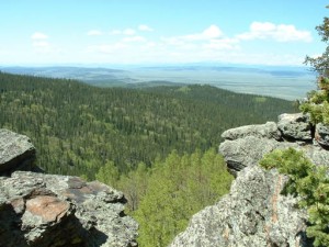
We got to the overlook and everyone enjoyed the view, but then as we were getting ready to leave it started to get overcast and it started to rain. Everyone quickly put the windows back in their Jeeps and we started out, just as it started to hail a little bit.

We continued on the trail through the hail as lightening struck less than a mile away. The hail got pretty big and thick around us. By the time we got to the first obstacle the water was pouring down the trail and the hail was really piling up.

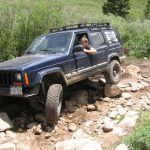
By the second obstacle it had cleared up again, though it left everything very muddy and slick. It made the rocks even more challenging but we all made it through.

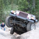
When we got to the big hill we were all surprised that it was difficult -- it's usually a fun hill but not particularly hard. This time it was very loose and wet and you really had to keep on the gas pedal to make it to the top. Monica and Bob S. made it up, then it was Alanna's turn.

Alanna tried a few different lines but nothing was working -- she kept getting stuck. In the end she ended up sideways on the hill, and in backing down she ended up with her front passenger tire on a foot-tall rock that was uphill, as she was sideways. Her rear passenger tire came up off the ground about three feet and she hovered there, not tipping over and rolling to the bottom. She slowly worked her way to the bottom and rode the rest of the way to the top of Twin Cone with Bob S. Maybe next time, Alanna!

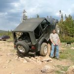
Jason and Dave both went up the big hill and came back down (they went back to Denver after this part). Aaron and Bob R. went up the hill then, keeping it on the gas but not really gunning it up the hill, making it look pretty easy.

We continued on and naturally it got chillier as we got higher in elevation and no longer had the trees to protect us from the wind. Aaron's lockers were acting up and Bob S. had some engine issues but it wasn't anything to prevent all of us from making it to the top at the weather station. It's a rocky trail all the way to the top.

We worked our way down and had decent weather all the way back (though it was cold). The windows were all in this time through so everyone went a little faster through the puddles. That meant we all ended up back at the trailhead covered in muddy water.

We ate at Sweet Fanny Adams in Bailey and found ourselves in the middle of a Bailey festival of some sort. It had an Irish theme and there was someone playing the bagpipes, another playing a fiddle, and a tap show at the end. We had a great meal and went home happy and tired.

aaron_at_the_overlook
aaron_in_the_hail_part_1
aaron_in_the_hail_part_2
aaron_on_the_first_obstacle_part_1
aaron_on_the_first_obstacle_part_2
aaron_on_the_first_obstacle_part_3
aaron_on_the_first_obstacle_part_4
aaron_on_the_first_obstacle_part_5
aaron_on_the_second_obstacle_part_1
aaron_on_the_second_obstacle_part_2
aaron_on_the_second_obstacle_part_3
aaron_rockclimbing
after_the_hail_storm
airing_down_part_1
airing_down_part_2
alanna_flexing
alanna_on_the_first_obstacle_part_1
alanna_on_the_first_obstacle_part_2
alanna_on_the_first_obstacle_part_3
alanna_on_the_first_obstacle_part_4
alanna_on_the_second_obstacle_part_1
alanna_on_the_second_obstacle_part_2
alanna_on_the_second_obstacle_part_3
alanna_on_the_second_obstacle_part_4
alanna_on_the_trail
alanna_splashing
alanna_stuck_on_the_big_hill
alanna_tippy_on_the_hill
alanna_tippy
almost_to_the_top
big_hill
big_puddle
bob_r_at_the_overlook
bob_r_in_the_hail_part_1
bob_r_in_the_hail_part_2
bob_r_on_the_big_hill
bob_r_on_the_first_obstacle_part_1
bob_r_on_the_first_obstacle_part_2
bob_r_on_the_first_obstacle_part_3
bob_r_on_the_first_obstacle_part_4
bob_r_on_the_second_obstacle_part_1
bob_r_on_the_second_obstacle_part_2
bob_r_on_the_second_obstacle_part_3
bob_r_on_the_trail
bob_r_with_south_twin_cone
bob_s_and_alanna
bob_s_down_the_big_hill
bob_s_flexing
bob_s_muddy
bob_s_on_the_first_obstacle_part_1
bob_s_on_the_first_obstacle_part_2
bob_s_on_the_second_obstacle_part_1
bob_s_on_the_second_obstacle_part_2
bob_s_on_the_second_obstacle_part_3
bob_s_on_the_second_obstacle_part_4
bob_s_on_the_second_obstacle_part_5
bob_s_on_the_trail
bob_s_rockclimbing
buddy_and_his_stick
climbing_to_the_top
dave_on_the_big_hill
dave_on_the_first_obstacle_part_1
dave_on_the_first_obstacle_part_2
dave_on_the_second_obstacle_part_1
dave_on_the_second_obstacle_part_2
dave_on_the_second_obstacle_part_3
everyone_on_the_big_hill
first_gate
hail_storm
jason_and_his_jeep_girl
jason_at_the_overlook
jason_in_the_hail_part_1
jason_in_the_hail_part_2
jason_on_the_big_hill
jason_on_the_first_obstacle_part_1
jason_on_the_first_obstacle_part_2
jason_on_the_first_obstacle_part_3
jason_on_the_second_obstacle_part_1
jason_on_the_second_obstacle_part_2
jason_on_the_second_obstacle_part_3
jason_on_the_second_obstacle_part_4
loose_hill
lunch
monica_at_the_top
monica_in_the_hail_part_1
monica_in_the_hail_part_2
monica_on_the_first_obstacle_part_1
monica_on_the_first_obstacle_part_2
monica_on_the_first_obstacle_part_3
monica_on_the_first_obstacle_part_4
monica_on_the_second_obstacle_part_1
monica_on_the_second_obstacle_part_2
monica_on_the_trail
morning_denver_fog
north_twin_cone
on_the_big_hill
red_cone_and_webster_pass
scenery
south_cone_from_the_overlook
south_park
south_twin_cone
start_of_the_trail
the_first_obstacle
the_second_obstacle
trail_to_the_top
trail_viewed_from_the_top
tree-lined_trail
view_from_near_the_top
view_from_the_overlook
wet_trail

Reports from Other Days: 6

Use the arrows or dots to flip through the previews of the other reports for Twin Cone. Click one of them to read more and see all of the photos from that day.

June 14, 2003

Led by Monica I.
We met up with some new friends and ran this trail fairly quickly. It’s pretty short and fast to run and you have to come back out the way you went in. The views were amazing! It was pretty cool to see Highway 285 from up there and really see…
«
  • 1
  • 2
  • 3
  • 4
  • 5
  • 6
Join Us!
If you aren’t a Member or Subscriber, you can’t see all of the content on this site. Get membership information to see why this site is best when you join and log in

Information for Subscribers

When you log in you’ll see more information here:

  • Recent Community Forum posts
  • Recent polls
  • Upcoming Events you can attend
  • Links to online users

© 2000-2023 · TrailDamage.com · Terms and Conditions · About · Contact
Trail information is only accurate on the date posted. Trails may have changed or closed since that date. Use this information for historical purposes only.
Contact the Forest Service or Bureau of Land Management for up-to-date trail information.

/* ----------------------------------------- */ /* View slug: reports-other-reports-for-same-trail-slider - start */ /* ----------------------------------------- */ /* place the prev/next controls on the sides */ .td-transition-controls .wpv-filter-next-link, .td-transition-controls .wpv-filter-previous-link { border: none; font-size: 300%; position: absolute; top: 70px; } .td-transition-controls .wpv-filter-previous-link { left: 0; } .td-transition-controls .wpv-filter-next-link { right: 0; } /* center the page selector horizonatally */ .td-transition-controls ul.wpv_pagination_dots { text-align: center; margin-top: 10px; } /* center the page selector horizonatally */ .td-transition-controls ul.wpv_pagination_dots li.wpv_pagination_dots_item, .td-transition-controls .wpv_pagination_dots li a { display: inline-block; float: none; } /* remove the default styles */ .td-transition-controls .wpv_pagination_dots li a { text-decoration: none; border-bottom: none; } .td-slider-container { padding: 0 25px; margin-bottom: 20px; position: relative; width:100%; display:table; } .td-slides { position: relative; } .td-slides-image { float:left; display:table-cell; } .td-slides-image img { border:1px solid #c0c0c0; } .td-slides-content { padding:4px 4px 4px 10px; border-top:1px solid #c0c0c0; border-right:1px solid #c0c0c0; border-bottom:1px solid #c0c0c0; display:table-cell; height:227px; overflow:hidden; } .td-slides-content h3 { margin-top:8px; } .td-slides-leader { font-size:smaller; margin-top:4px; } /* ----------------------------------------- */ /* View slug: reports-other-reports-for-same-trail-slider - end */ /* ----------------------------------------- */
/* ----------------------------------------- */ /* Content Template: Template for a Single Report - start */ /* ----------------------------------------- */ .entry-header { display:none; } .entry-content h1 { margin-top:16px; padding-top:0; } h1 a { color:#222; } h1 a:hover { color:#666; } p.entry-meta { font-size:small; } #report-body-spacer { clear:both; width:100%; height:20px; } #addtoany-bar { margin-bottom:2em; text-align:center; } .category-reports .post-info .author, .post-info .date { display: none; } .addthis_recommended_horizontal { text-align:center !important; } /* ----------------------------------------- */ /* Content Template: Template for a Single Report - end */ /* ----------------------------------------- */ /* ----------------------------------------- */ /* Content Template: Loop item in REPORTS Runners - start */ /* ----------------------------------------- */ #runners-container { width:100%; clear:both; } .runner { border:1px solid #c0c0c0; margin:0 6px 6px 0; float:left; width:49%; height:81px; } .runner-image { float: left; } .runner-image img { margin:2px 10px 0 2px; height:75px; width:75px; } .runner-name { text-transform:uppercase; } .runner-name a { color:#222; } .runner-name a:hover { color:#666; } .runner-vehicle { font-size:small; } @media only screen and (max-width: 768px) { .runner { width:100%; } } /* ----------------------------------------- */ /* Content Template: Loop item in REPORTS Runners - end */ /* ----------------------------------------- */