TrailDamage.com

Photos, videos and information about 4x4 trails in Colorado and Utah

  • Trails
    • Colorado
    • Utah
  • Reports
    • Featured Photos
    • Featured Videos
    • Reports Calendar
  • Members
  • Search
  • Trail Damage Winners
  • FAQ
  • Community
  • Upcoming Events
  • Membership
  • Log In
  • Facebook
  • Instagram
  • RSS
  • Twitter
  • YouTube

Spring Canyon Bottom 170514

May 14, 2017 by Monica

Spring Canyon Bottom

Trail Run on May 14, 2017
Report and photos by Monica I., Trail Leader
View trail information for Spring Canyon Bottom

Mike S.
Silver 2004 Jeep Wrangler Rubicon
Matt K.
White 2016 Jeep Wrangler Unlimited Rubicon
Walt S.
Gray 2022 Jeep Wrangler Unlimited Rubicon 392

We had a big loop planned for the day that started on Blue Hills Road and ended on Crystal Geyser.  Spring Canyon Bottom would take us through a good portion of the middle of that loop, so we left Highway 313 and headed in.  The morning was crisp and cool, with no clouds in the sky.

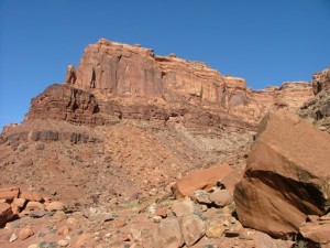
We turned left when we got to Deadman Point, and trail we'd been planning to do for about a decade.  It gave us a nice overlook of where we'd be going on Spring Canyon Bottom.  In fact, we weren't even planning on taking the time to go down to the river but we discussed it and decided to make it a longer day and see it.  It was definitely worth it.

We stopped at the top of the steep and narrow descent for a little while, trying to see the wreckage over the edge.  It's tough to get close enough to the edge, and Matt even jumped down to a small ledge for a better look.  We went through the gate and closed it behind us, and we were lucky to not run into anyone on their way up.

The descent is so steep and so scenic, and we remembered why we liked this trail so much.  As we got lower into the canyon, the temperatures rose.  We needed jackets at the top, and by the time we got to the bottom we were down to t-shirts and shorts.  It was a massive change.

We saw a few people on dirt bikes and ATVs heading into Hey Joe Canyon, but we happily went the other way.  The tamerisk was thick, and we knew it would be a mess in there.  Instead, we headed the other way along the river.  The water was close by as we weaved along next to it.  It was really hot down there, even next to the river.

We got to a spot where the trail went into the water and it leaned Mike way into it on one side before he could climb out.  He told the others to wait, and rushed ahead to find a place to turn around.  He did, and came right back.  That was as far as we needed to go.

We had lunch under the big cottonwood trees near the intersection with Hey Joe Canyon.  It was really windy, but still nice.  Then we headed back up into cooler temperatures without any issues.  Off to the next trail!

P1040472
P1040517
P1040518
P1040520
P1040521
P1040522
P1040523
P1040524
P1040525
P1040526
P1040527
P1040528
P1040529
P1040530
P1040531
P1040532
P1040533
P1040534
P1040535
P1040537
P1040538
P1040539
P1040540
P1040541
P1040542
P1040544
P1040545
P1040546
P1040547
P1040548
P1040549
P1040551
P1040552
P1040553
P1040555
P1040556
P1040557
P1040558
P1040559
P1040560
P1040561
P1040562
P1040563
P1040564
P1040565
P1040567
P1040568
P1040571
P1040572
P1040573
P1040574
P1040576
P1040577
P1040578
P1040579
P1040580
P1040581
P1040582
P1040583
P1040584
P1040585
P1040587
P1040588
P1040589
P1040590
P1040591
P1040596
P1040598
P1040599
P1040600
P1040602
P1040603
P1040607
P1040608
P1040609
P1040610
P1040612
P1040613
P1040614

Reports from Other Days: 2

Use the arrows or dots to flip through the previews of the other reports for Spring Canyon Bottom. Click one of them to read more and see all of the photos from that day.

October 14, 2004

Led by Monica I.
This was the first trail of the Moab trip and we enjoyed a slow start with beautiful views and a blue sky. Though we got pretty turned around in the beginning we eventually found our way to the trail and worked our way down to the end and Hey Joe…
«
  • 1
  • 2
Join Us!
If you aren’t a Member or Subscriber, you can’t see all of the content on this site. Get membership information to see why this site is best when you join and log in

Information for Subscribers

When you log in you’ll see more information here:

  • Recent Community Forum posts
  • Recent polls
  • Upcoming Events you can attend
  • Links to online users

© 2000-2023 · TrailDamage.com · Terms and Conditions · About · Contact
Trail information is only accurate on the date posted. Trails may have changed or closed since that date. Use this information for historical purposes only.
Contact the Forest Service or Bureau of Land Management for up-to-date trail information.

/* ----------------------------------------- */ /* View slug: reports-other-reports-for-same-trail-slider - start */ /* ----------------------------------------- */ /* place the prev/next controls on the sides */ .td-transition-controls .wpv-filter-next-link, .td-transition-controls .wpv-filter-previous-link { border: none; font-size: 300%; position: absolute; top: 70px; } .td-transition-controls .wpv-filter-previous-link { left: 0; } .td-transition-controls .wpv-filter-next-link { right: 0; } /* center the page selector horizonatally */ .td-transition-controls ul.wpv_pagination_dots { text-align: center; margin-top: 10px; } /* center the page selector horizonatally */ .td-transition-controls ul.wpv_pagination_dots li.wpv_pagination_dots_item, .td-transition-controls .wpv_pagination_dots li a { display: inline-block; float: none; } /* remove the default styles */ .td-transition-controls .wpv_pagination_dots li a { text-decoration: none; border-bottom: none; } .td-slider-container { padding: 0 25px; margin-bottom: 20px; position: relative; width:100%; display:table; } .td-slides { position: relative; } .td-slides-image { float:left; display:table-cell; } .td-slides-image img { border:1px solid #c0c0c0; } .td-slides-content { padding:4px 4px 4px 10px; border-top:1px solid #c0c0c0; border-right:1px solid #c0c0c0; border-bottom:1px solid #c0c0c0; display:table-cell; height:227px; overflow:hidden; } .td-slides-content h3 { margin-top:8px; } .td-slides-leader { font-size:smaller; margin-top:4px; } /* ----------------------------------------- */ /* View slug: reports-other-reports-for-same-trail-slider - end */ /* ----------------------------------------- */
/* ----------------------------------------- */ /* Content Template: Template for a Single Report - start */ /* ----------------------------------------- */ .entry-header { display:none; } .entry-content h1 { margin-top:16px; padding-top:0; } h1 a { color:#222; } h1 a:hover { color:#666; } p.entry-meta { font-size:small; } #report-body-spacer { clear:both; width:100%; height:20px; } #addtoany-bar { margin-bottom:2em; text-align:center; } .category-reports .post-info .author, .post-info .date { display: none; } .addthis_recommended_horizontal { text-align:center !important; } /* ----------------------------------------- */ /* Content Template: Template for a Single Report - end */ /* ----------------------------------------- */ /* ----------------------------------------- */ /* Content Template: Loop item in REPORTS Runners - start */ /* ----------------------------------------- */ #runners-container { width:100%; clear:both; } .runner { border:1px solid #c0c0c0; margin:0 6px 6px 0; float:left; width:49%; height:81px; } .runner-image { float: left; } .runner-image img { margin:2px 10px 0 2px; height:75px; width:75px; } .runner-name { text-transform:uppercase; } .runner-name a { color:#222; } .runner-name a:hover { color:#666; } .runner-vehicle { font-size:small; } @media only screen and (max-width: 768px) { .runner { width:100%; } } /* ----------------------------------------- */ /* Content Template: Loop item in REPORTS Runners - end */ /* ----------------------------------------- */