TrailDamage.com

Photos, videos and information about 4x4 trails in Colorado and Utah

  • Trails
    • Colorado
    • Utah
  • Reports
    • Featured Photos
    • Featured Videos
    • Reports Calendar
  • Members
  • Search
  • Trail Damage Winners
  • FAQ
  • Community
  • Upcoming Events
  • Membership
  • Log In
  • Facebook
  • Instagram
  • RSS
  • Twitter
  • YouTube

Slickrock Mesa 081030

October 30, 2008 by Monica

Slickrock Mesa

Trail Run on October 30, 2008
Report and photos by Monica I., Trail Leader
View trail information for Slickrock Mesa

Roger R.
White 2005 Jeep Wrangler Unlimited Rubicon
Monica I.
Red 2010 Jeep Wrangler Rubicon
Mike S.
Silver 2004 Jeep Wrangler Rubicon
Jeffrey M.
Khaki 2006 Jeep Wrangler Unlimited Rubicon
Michael M.
Black 2006 Jeep Wrangler Unlimited Rubicon

We weren't sure what we were going to find on Slickrock Mesa. It looked like a fairly straight trail that ended in a bizarre place, but it was worth a little exploration. We were happy to find one of the best trails of the trip.

The trail started right off of the easy end of Long Canyon, and it was also pretty easy at the start. Then we found ourselves in a wide, flat area with lots of new equipment to be used for oil drilling or refining. We thought we were already done, but then the trail continued on the other side.

Just a bit further past this point we saw another trail to our left. This is probably another way in, and a better way. We had seen another spur leaving Long Canyon just before our actual trailhead, and that might be better. We'll check that out next time.

The trail didn't look well-used, but there were tracks in the dirt in front of us and cairns every once in awhile. We had a track to follow, so we kept at it.

The trail suddenly turned to a steep downhill for awhile, and we were having fun on it. When it mellowed out again, it got curvy and the rocky sections started.

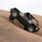
Even though it's called Slickrock Mesa the trail doesn't spend much of its time on slickrock. There are some slickrock sections, but not many. Slickrock is often found in the trail in the form of stairs, steps and shelves. There is a particularly nice set of shelves in the trail that was a lot of fun.

The GPS track we were following was from a USGS map, but it ended. The actual trail just kept going, so we followed it. It had to go somewhere! We continued following the same tire tracks in the dirt, making trail finding challenging but not impossible.

There were some great views of the areas around us, including the Gemini Bridges area. You could even see Gooney Bird Rock from there. The views of the La Sal mountains and the fins in front of them were also pretty and difficult to capture on camera.

The trail came to a loop and we were at the end. We walked out and found a good overlook of the river, which is where the trail was headed. It's not the best overlook in the area -- not by a long shot -- but it sure was fun getting there.

We turned to go back and had the sun in our eyes for a bit. Then it went behind the ridge and we all enjoyed the trip up to the trailhead. It was even more fun on the way up, with all of the obstacles going uphill.

We'll definitely add this trail to our list of favorites. It would be good to do it again when we had more light, so we could get more pictures of the actual obstacles. This was a really good time.

bumpy
fins_and_mountains_part_1
fins_and_mountains_part_2
fins_and_mountains_part_3
fins_and_mountains_part_4
fins_and_mountains_part_5
fins_and_mountains_part_6
fins_and_mountains_part_7
gemini_bridges_area_part_1
gemini_bridges_area_part_2
hill
jeffrey_and_mike
jeffrey_up_shelves_part_1
jeffrey_up_shelves_part_2
jeffrey_up_shelves_part_3
jeffrey_up_shelves_part_4
little_trail
mellow_at_first
michael_up_shelves_part_1
michael_up_shelves_part_2
michael_up_shelves_part_3
michael_up_shelves_part_4
michael_up_shelves_part_5
mike_and_roger_down_shelves
mike_on_the_trail
mike_up_shelves_part_1
mike_up_shelves_part_2
mike_up_shelves_part_3
mike_up_shelves_part_4
mike_up_shelves_part_5
mike_up_shelves_part_6
mike_up_shelves_part_7
overgrown_trail
overlook_part_1
overlook_part_2
overlook_part_3
private_property
roger_on_the_trail
roger_up_shelves_part_1
roger_up_shelves_part_2
roger_up_shelves_part_3
roger_up_shelves_part_4
roger_up_shelves_part_5
roger_up_shelves_part_6
roger_up_shelves_part_7
start_of_the_trail
steps
Join Us!
If you aren’t a Member or Subscriber, you can’t see all of the content on this site. Get membership information to see why this site is best when you join and log in

Information for Subscribers

When you log in you’ll see more information here:

  • Recent Community Forum posts
  • Recent polls
  • Upcoming Events you can attend
  • Links to online users

© 2000-2021 · TrailDamage.com · Terms and Conditions · About · Contact
Trail information is only accurate on the date posted. Trails may have changed or closed since that date. Use this information for historical purposes only.
Contact the Forest Service or Bureau of Land Management for up-to-date trail information.

/* ----------------------------------------- */ /* View slug: reports-other-reports-for-same-trail-slider - start */ /* ----------------------------------------- */ /* place the prev/next controls on the sides */ .td-transition-controls .wpv-filter-next-link, .td-transition-controls .wpv-filter-previous-link { border: none; font-size: 300%; position: absolute; top: 70px; } .td-transition-controls .wpv-filter-previous-link { left: 0; } .td-transition-controls .wpv-filter-next-link { right: 0; } /* center the page selector horizonatally */ .td-transition-controls ul.wpv_pagination_dots { text-align: center; margin-top: 10px; } /* center the page selector horizonatally */ .td-transition-controls ul.wpv_pagination_dots li.wpv_pagination_dots_item, .td-transition-controls .wpv_pagination_dots li a { display: inline-block; float: none; } /* remove the default styles */ .td-transition-controls .wpv_pagination_dots li a { text-decoration: none; border-bottom: none; } .td-slider-container { padding: 0 25px; margin-bottom: 20px; position: relative; width:100%; display:table; } .td-slides { position: relative; } .td-slides-image { float:left; display:table-cell; } .td-slides-image img { border:1px solid #c0c0c0; } .td-slides-content { padding:4px 4px 4px 10px; border-top:1px solid #c0c0c0; border-right:1px solid #c0c0c0; border-bottom:1px solid #c0c0c0; display:table-cell; height:227px; overflow:hidden; } .td-slides-content h3 { margin-top:8px; } .td-slides-leader { font-size:smaller; margin-top:4px; } /* ----------------------------------------- */ /* View slug: reports-other-reports-for-same-trail-slider - end */ /* ----------------------------------------- */
/* ----------------------------------------- */ /* Content Template: Template for a Single Report - start */ /* ----------------------------------------- */ .entry-header { display:none; } .entry-content h1 { margin-top:16px; padding-top:0; } h1 a { color:#222; } h1 a:hover { color:#666; } p.entry-meta { font-size:small; } #report-body-spacer { clear:both; width:100%; height:20px; } #addtoany-bar { margin-bottom:2em; text-align:center; } .category-reports .post-info .author, .post-info .date { display: none; } .addthis_recommended_horizontal { text-align:center !important; } /* ----------------------------------------- */ /* Content Template: Template for a Single Report - end */ /* ----------------------------------------- */ /* ----------------------------------------- */ /* Content Template: Loop item in REPORTS Runners - start */ /* ----------------------------------------- */ #runners-container { width:100%; clear:both; } .runner { border:1px solid #c0c0c0; margin:0 6px 6px 0; float:left; width:49%; height:81px; } .runner-image { float: left; } .runner-image img { margin:2px 10px 0 2px; height:75px; width:75px; } .runner-name { text-transform:uppercase; } .runner-name a { color:#222; } .runner-name a:hover { color:#666; } .runner-vehicle { font-size:small; } @media only screen and (max-width: 768px) { .runner { width:100%; } } /* ----------------------------------------- */ /* Content Template: Loop item in REPORTS Runners - end */ /* ----------------------------------------- */