TrailDamage.com

Photos, videos and information about 4x4 trails in Colorado and Utah

  • Trails
    • Colorado
    • Utah
  • Reports
    • Featured Photos
    • Featured Videos
    • Reports Calendar
  • Members
  • Search
  • Trail Damage Winners
  • FAQ
  • Community
  • Upcoming Events
  • Membership
  • Log In
  • Facebook
  • Instagram
  • RSS
  • Twitter
  • YouTube

Sevenmile Mesa 200523

May 23, 2020 by Monica

Sevenmile Mesa

Trail Run on May 23, 2020
Report and photos by Monica I., Trail Leader
View trail information for Sevenmile Mesa

Julie M.
Green 2012 Jeep Wrangler Unlimited Rubicon
Niko K.
Gray 2017 Jeep Wrangler Unlimited
Carter C.
Gray 2018 Jeep Wrangler Unlimited Rubicon

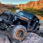
We decided to tackle some new trails instead of doing some we'd done before, so after checking out the Dolores River Overlook trail we decided to head farther north and hopefully get to the top of Sevenmile Mesa.  We got lucky, the trail was still there, and it was a blast.

It was a pretty mellow trail until we started climbing.  The views were awesome, and the trail got interesting right away.  We had to squeeze between two rocks along trail that was often narrow and loose near the edges.  There were already rocks piled into holes that might have made things a little too interesting, so we didn't have any issues.

Right after that, the trail leaned us out toward the edge as we went around a little corner.  The whole climb to the top was filled with little challenges and skinny sections, and everyone enjoyed it.

We were cruising along and went down into a wash, and found ourselves at a crossroads.  The wash would take us back out, but we weren't quite done with the mesa.  So we headed up the Rock Wall to see some more of it.

There were nice, big views up there along with a skinny section that had bushes growing in the middle of the trail.  But it wasn't washed out, so we pressed on.

It felt really remote the farther north we went.  There were lots of spurs, but we had our eye on the northernmost point at an overlook.  But we were starting to realize how far we still had to go and how late it was getting.  We still had a long way back to Moab.  So when we found a loop we could do, we made our end to the trail.  We'd save the overlook for another time.

We went back down the Rock Wall and headed into the wash, which was really fun.  It had sandy stretches mixed with stretches of fun river rocks and boulders.  But it didn't last long enough, and soon we were back on the Dolores River Overlook trail.

We headed back to the Dewey Suspension Bridge to air up and head back to town to meet Matt.  It was a great start to our Moab trip.

P1050459
P1050460
P1050461
P1050462
P1050463
P1050464
P1050465
P1050466
P1050467
P1050468
P1050469
P1050470
P1050471
P1050472
P1050473
P1050474
P1050475
P1050476
P1050478
P1050479
P1050480
P1050481
P1050482
P1050483
P1050484
P1050485
P1050486
P1050487
P1050489
P1050491
P1050492
P1050493
P1050494
P1050495
P1050496
P1050497
P1050499
P1050500
P1050501
P1050503
P1050504
P1050505
P1050506
P1050507
P1050508
P1050509
P1050510
P1050511
P1050512
P1050513
P1050514
P1050515
P1050516
P1050517
P1050518
P1050519
P1050520
P1050521
P1050522
P1050523
P1050525
P1050526
P1050527
P1050528
P1050529
P1050530
P1050531
P1050532
P1050533
P1050534
P1050535
P1050536
P1050537
P1050538
P1050539
P1050540
P1050541
P1050542
P1050543
P1050544
P1050545
P1050546
P1050547
P1050548
P1050549
P1050550
P1050551
P1050553
P1050554
P1050555
P1050556
P1050557
Join Us!
If you aren’t a Member or Subscriber, you can’t see all of the content on this site. Get membership information to see why this site is best when you join and log in

Information for Subscribers

When you log in you’ll see more information here:

  • Recent Community Forum posts
  • Recent polls
  • Upcoming Events you can attend
  • Links to online users

© 2000-2021 · TrailDamage.com · Terms and Conditions · About · Contact
Trail information is only accurate on the date posted. Trails may have changed or closed since that date. Use this information for historical purposes only.
Contact the Forest Service or Bureau of Land Management for up-to-date trail information.

/* ----------------------------------------- */ /* View slug: reports-other-reports-for-same-trail-slider - start */ /* ----------------------------------------- */ /* place the prev/next controls on the sides */ .td-transition-controls .wpv-filter-next-link, .td-transition-controls .wpv-filter-previous-link { border: none; font-size: 300%; position: absolute; top: 70px; } .td-transition-controls .wpv-filter-previous-link { left: 0; } .td-transition-controls .wpv-filter-next-link { right: 0; } /* center the page selector horizonatally */ .td-transition-controls ul.wpv_pagination_dots { text-align: center; margin-top: 10px; } /* center the page selector horizonatally */ .td-transition-controls ul.wpv_pagination_dots li.wpv_pagination_dots_item, .td-transition-controls .wpv_pagination_dots li a { display: inline-block; float: none; } /* remove the default styles */ .td-transition-controls .wpv_pagination_dots li a { text-decoration: none; border-bottom: none; } .td-slider-container { padding: 0 25px; margin-bottom: 20px; position: relative; width:100%; display:table; } .td-slides { position: relative; } .td-slides-image { float:left; display:table-cell; } .td-slides-image img { border:1px solid #c0c0c0; } .td-slides-content { padding:4px 4px 4px 10px; border-top:1px solid #c0c0c0; border-right:1px solid #c0c0c0; border-bottom:1px solid #c0c0c0; display:table-cell; height:227px; overflow:hidden; } .td-slides-content h3 { margin-top:8px; } .td-slides-leader { font-size:smaller; margin-top:4px; } /* ----------------------------------------- */ /* View slug: reports-other-reports-for-same-trail-slider - end */ /* ----------------------------------------- */
/* ----------------------------------------- */ /* Content Template: Template for a Single Report - start */ /* ----------------------------------------- */ .entry-header { display:none; } .entry-content h1 { margin-top:16px; padding-top:0; } h1 a { color:#222; } h1 a:hover { color:#666; } p.entry-meta { font-size:small; } #report-body-spacer { clear:both; width:100%; height:20px; } #addtoany-bar { margin-bottom:2em; text-align:center; } .category-reports .post-info .author, .post-info .date { display: none; } .addthis_recommended_horizontal { text-align:center !important; } /* ----------------------------------------- */ /* Content Template: Template for a Single Report - end */ /* ----------------------------------------- */ /* ----------------------------------------- */ /* Content Template: Loop item in REPORTS Runners - start */ /* ----------------------------------------- */ #runners-container { width:100%; clear:both; } .runner { border:1px solid #c0c0c0; margin:0 6px 6px 0; float:left; width:49%; height:81px; } .runner-image { float: left; } .runner-image img { margin:2px 10px 0 2px; height:75px; width:75px; } .runner-name { text-transform:uppercase; } .runner-name a { color:#222; } .runner-name a:hover { color:#666; } .runner-vehicle { font-size:small; } @media only screen and (max-width: 768px) { .runner { width:100%; } } /* ----------------------------------------- */ /* Content Template: Loop item in REPORTS Runners - end */ /* ----------------------------------------- */