TrailDamage.com

Photos, videos and information about 4x4 trails in Colorado and Utah

  • Trails
    • Colorado
    • Utah
  • Reports
    • Featured Photos
    • Featured Videos
    • Reports Calendar
  • Members
  • Search
  • Trail Damage Winners
  • FAQ
  • Community
  • Upcoming Events
  • Membership
  • Log In
  • Facebook
  • Instagram
  • RSS
  • Twitter
  • YouTube

Santa Fe Peak 110924

September 24, 2011 by Monica

Santa Fe Peak

Trail Run on September 24, 2011
Report and photos by Monica I., Trail Leader
View trail information for Santa Fe Peak

Walt S.
Gray 2018 Jeep Wrangler Unlimited Rubicon
Mark F.
Blue 2002 Jeep Wrangler
Hoa Q.
Black 1995 Land Rover Range Rover
Monica I.
Red 2010 Jeep Wrangler Rubicon
Matt K.
White 2016 Jeep Wrangler Unlimited Rubicon
Roger R.
White 2005 Jeep Wrangler Unlimited Rubicon
Mike S.
Silver 2004 Jeep Wrangler Rubicon
Bill S.
Khaki 2004 Jeep Wrangler Rubicon

We had our fingers crossed and all of the wishing worked because we had fantastic weather. When we first did Santa Fe Peak the fog and clouds were so thick that we didn't really see much of the scenery around the trail. We were really looking forward to really seeing everything this time.

It wasn't long before we were headed up the trail. Fall had really started and we saw aspen leaves changing to yellow on our drive to the trail. There weren't many aspens near the trail itself but the fall colors were all around us.

The climb through the trees was uneventful, and when we got to the Quail Mine we saw a group of vehicles heading down. We found room at that switchback to get out of the way to let them by us. It worked out very well.

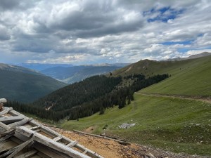
The climb to the top was absolutely gorgeous. Hoa had some photographer friends with him and they all enjoyed taking lots of pictures of the mountains around us.

The last shelf road around the top of the peak itself was a little daunting the first time because we couldn't see how far the drop off really was. This time it was dry and the skies were clear so we could see everything. It was still a bit intimidating but somehow it was easier when we could see better.

When we got to the end no one decided to continue down the last little bit so we all stopped. We were walking around for a while. It was odd because it wasn't windy at all even though we were at the top of a mountain. The sun felt good and no one wanted to leave. Even though it was a bit early for lunch we decided to eat there. It was just too perfect to leave it just yet.

But we had a lot of trails to do so we eventually packed up and headed down. We saw a couple other vehicles but they took advantage of the Quail Mine switchback to let our group go past them.

Once we got back down to Montezuma we headed one block over to start up Saints John. It was already the perfect day and we were just getting started.

above_timberline
airing_down
aspens
bumpy
climbing
early_trail
exposed_trail
fall_colors
flat_section
following_the_trail
geneva_creek_basin
glacier_mountain
hammertime
heading_down
hoa_and_matt
hoa_on_the_trail_part_1
hoa_on_the_trail_part_2
into_the_sky
layers
lower_switchback
lunch_part_1
lunch_part_2
many_colors
matt_at_the_top
matt_on_the_trail
monica_at_the_top
mountain_view
on_the_trail_part_1
on_the_trail_part_2
patches_of_snow
quail_mine_part_1
quail_mine_part_2
rocky_switchback
shelf_road_part_1
shelf_road_part_2
shelf_road_part_3
shelf_road_part_4
snowy
story_time
trail_to_nowhere
valley_view
view_from_the_top_part_1
view_from_the_top_part_2
view_from_the_top_part_3
view_from_the_top_part_4

Report from a Different Day

September 12, 2009

Led by Monica I.
Santa Fe Peak is one of those trails. We tried to run it in 2007 but when we got to the exposed section there was just too much snow. We turned around and headed back down, intending to run it in 2008. But when we got there in 2008 there…
Join Us!
If you aren’t a Member or Subscriber, you can’t see all of the content on this site. Get membership information to see why this site is best when you join and log in

Information for Subscribers

When you log in you’ll see more information here:

  • Recent Community Forum posts
  • Recent polls
  • Upcoming Events you can attend
  • Links to online users

© 2000-2021 · TrailDamage.com · Terms and Conditions · About · Contact
Trail information is only accurate on the date posted. Trails may have changed or closed since that date. Use this information for historical purposes only.
Contact the Forest Service or Bureau of Land Management for up-to-date trail information.

/* ----------------------------------------- */ /* View slug: reports-other-reports-for-same-trail-slider - start */ /* ----------------------------------------- */ /* place the prev/next controls on the sides */ .td-transition-controls .wpv-filter-next-link, .td-transition-controls .wpv-filter-previous-link { border: none; font-size: 300%; position: absolute; top: 70px; } .td-transition-controls .wpv-filter-previous-link { left: 0; } .td-transition-controls .wpv-filter-next-link { right: 0; } /* center the page selector horizonatally */ .td-transition-controls ul.wpv_pagination_dots { text-align: center; margin-top: 10px; } /* center the page selector horizonatally */ .td-transition-controls ul.wpv_pagination_dots li.wpv_pagination_dots_item, .td-transition-controls .wpv_pagination_dots li a { display: inline-block; float: none; } /* remove the default styles */ .td-transition-controls .wpv_pagination_dots li a { text-decoration: none; border-bottom: none; } .td-slider-container { padding: 0 25px; margin-bottom: 20px; position: relative; width:100%; display:table; } .td-slides { position: relative; } .td-slides-image { float:left; display:table-cell; } .td-slides-image img { border:1px solid #c0c0c0; } .td-slides-content { padding:4px 4px 4px 10px; border-top:1px solid #c0c0c0; border-right:1px solid #c0c0c0; border-bottom:1px solid #c0c0c0; display:table-cell; height:227px; overflow:hidden; } .td-slides-content h3 { margin-top:8px; } .td-slides-leader { font-size:smaller; margin-top:4px; } /* ----------------------------------------- */ /* View slug: reports-other-reports-for-same-trail-slider - end */ /* ----------------------------------------- */
/* ----------------------------------------- */ /* Content Template: Template for a Single Report - start */ /* ----------------------------------------- */ .entry-header { display:none; } .entry-content h1 { margin-top:16px; padding-top:0; } h1 a { color:#222; } h1 a:hover { color:#666; } p.entry-meta { font-size:small; } #report-body-spacer { clear:both; width:100%; height:20px; } #addtoany-bar { margin-bottom:2em; text-align:center; } .category-reports .post-info .author, .post-info .date { display: none; } .addthis_recommended_horizontal { text-align:center !important; } /* ----------------------------------------- */ /* Content Template: Template for a Single Report - end */ /* ----------------------------------------- */ /* ----------------------------------------- */ /* Content Template: Loop item in REPORTS Runners - start */ /* ----------------------------------------- */ #runners-container { width:100%; clear:both; } .runner { border:1px solid #c0c0c0; margin:0 6px 6px 0; float:left; width:49%; height:81px; } .runner-image { float: left; } .runner-image img { margin:2px 10px 0 2px; height:75px; width:75px; } .runner-name { text-transform:uppercase; } .runner-name a { color:#222; } .runner-name a:hover { color:#666; } .runner-vehicle { font-size:small; } @media only screen and (max-width: 768px) { .runner { width:100%; } } /* ----------------------------------------- */ /* Content Template: Loop item in REPORTS Runners - end */ /* ----------------------------------------- */