TrailDamage.com

Photos, videos and information about 4x4 trails in Colorado and Utah

  • Trails
    • Colorado
    • Utah
  • Reports
    • Featured Photos
    • Featured Videos
    • Reports Calendar
  • Members
  • Search
  • Trail Damage Winners
  • FAQ
  • Community
  • Upcoming Events
  • Membership
  • Log In
  • Facebook
  • Instagram
  • RSS
  • Twitter
  • YouTube

Ruby Jewel 180615

June 15, 2018 by Monica

Ruby Jewel

Trail Run on June 15, 2018
Report and photos by Monica I., Trail Leader
View trail information for Ruby Jewel

Niko K.
Gray 2017 Jeep Wrangler Unlimited
Mike S.
Silver 2004 Jeep Wrangler Rubicon

The first time we were in this area we didn't have time to check out anything but the main roads, so we skipped Ruby Jewel.  We were really looking forward to seeing it this time and possibly doing the hike at the end.  We came off of Bockman Road and County Road 41 and started up the new trail.

We started on the southern end of the loop because we wanted to get to the end a bit earlier.  We were still deciding on hiking or not.  For us, it's always a balance between 4x4 trails and other activities -- if we go hiking, that's fewer trails we'll see in our Jeeps.  We decided to wait until we got to the hiking trailhead to decide.

A lot of the trail is in the open, with evidence of logging everywhere.  Though there are still parts of the forest thick with pine and aspen trees, there were a lot of areas on the trail where there was deadwood and stumps all over the place.  It wasn't particularly attractive.

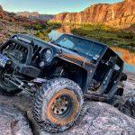
We saw one car parked in the 4x4 parking, but no people.  We kept going, of course, and the trail turned to a bumpy bit of fun.  When we got to the main rocks, Mike decided to see if he could straddle one of the larger rocks.  He couldn't, so he had to back down and do the obstacle with his tires on them, instead.

Niko took the path that was the most flexy, and it paid off.  He had a fun time through the rocks.

It wasn't long until we were at the end.  We parked, and walked a little way into the trail.  We stood on the foot bridge and decided we weren't going to hike.  Mostly, it was the thick mosquitoes that turned us away.  It was also a pretty steep trail.  Instead, we had a slightly early lunch in the sun and tried not to get too many mosquito bites (it didn't work).

We soon headed down, anxious to get out of all of the mosquitoes.  We took the other half of the loop and decided to head out to the overlook.  It was high on the hill for a bit, and we thought that's where it would be.  But then the trail headed down the hill and into the trees, where it finally stopped at a turnaround.  We laughed, got out, walked around, laughed some more.  You couldn't see much from there, and it wasn't relatively scenic.  We dubbed it the "underlook."

We headed back out to the main road after finishing the loop.  This was a fun trail, and we were glad we finally got to see it.

P1010298
P1010299
P1010301
P1010302
P1010303
P1010304
P1010305
P1010306
P1010307
P1010308
P1010309
P1010310
P1010311
P1010312
P1010313
P1010315
P1010316
P1010317
P1010318
P1010319
P1010320
P1010321
P1010322
P1010323
P1010325
P1010326
P1010327
P1010328
P1010330
P1010331
P1010333
P1010334
P1010335
P1010336
P1010337
P1010338
P1010339
P1010340
P1010341
P1010342
P1010343
P1010345
P1010346
P1010347
P1010348
P1010349
P1010350
P1010351
P1010352
P1010353
P1010354
P1010355
P1010356
P1010357
P1010358
P1010359
P1010360
P1010361
P1010362
P1010363
P1010364
P1010365
P1010366
P1010368
P1010369
P1010370
P1010371
P1010372
P1010373
P1010374
P1010375
P1010376
P1010377
P1010378
P1010379
P1010380
P1010381
P1010382
P1010383
P1010384
P1010385
P1010386
P1010387
P1010388
P1010389
P1010390
P1010391
P1010392
Join Us!
If you aren’t a Member or Subscriber, you can’t see all of the content on this site. Get membership information to see why this site is best when you join and log in

Information for Subscribers

When you log in you’ll see more information here:

  • Recent Community Forum posts
  • Recent polls
  • Upcoming Events you can attend
  • Links to online users

© 2000-2023 · TrailDamage.com · Terms and Conditions · About · Contact
Trail information is only accurate on the date posted. Trails may have changed or closed since that date. Use this information for historical purposes only.
Contact the Forest Service or Bureau of Land Management for up-to-date trail information.

/* ----------------------------------------- */ /* View slug: reports-other-reports-for-same-trail-slider - start */ /* ----------------------------------------- */ /* place the prev/next controls on the sides */ .td-transition-controls .wpv-filter-next-link, .td-transition-controls .wpv-filter-previous-link { border: none; font-size: 300%; position: absolute; top: 70px; } .td-transition-controls .wpv-filter-previous-link { left: 0; } .td-transition-controls .wpv-filter-next-link { right: 0; } /* center the page selector horizonatally */ .td-transition-controls ul.wpv_pagination_dots { text-align: center; margin-top: 10px; } /* center the page selector horizonatally */ .td-transition-controls ul.wpv_pagination_dots li.wpv_pagination_dots_item, .td-transition-controls .wpv_pagination_dots li a { display: inline-block; float: none; } /* remove the default styles */ .td-transition-controls .wpv_pagination_dots li a { text-decoration: none; border-bottom: none; } .td-slider-container { padding: 0 25px; margin-bottom: 20px; position: relative; width:100%; display:table; } .td-slides { position: relative; } .td-slides-image { float:left; display:table-cell; } .td-slides-image img { border:1px solid #c0c0c0; } .td-slides-content { padding:4px 4px 4px 10px; border-top:1px solid #c0c0c0; border-right:1px solid #c0c0c0; border-bottom:1px solid #c0c0c0; display:table-cell; height:227px; overflow:hidden; } .td-slides-content h3 { margin-top:8px; } .td-slides-leader { font-size:smaller; margin-top:4px; } /* ----------------------------------------- */ /* View slug: reports-other-reports-for-same-trail-slider - end */ /* ----------------------------------------- */
/* ----------------------------------------- */ /* Content Template: Template for a Single Report - start */ /* ----------------------------------------- */ .entry-header { display:none; } .entry-content h1 { margin-top:16px; padding-top:0; } h1 a { color:#222; } h1 a:hover { color:#666; } p.entry-meta { font-size:small; } #report-body-spacer { clear:both; width:100%; height:20px; } #addtoany-bar { margin-bottom:2em; text-align:center; } .category-reports .post-info .author, .post-info .date { display: none; } .addthis_recommended_horizontal { text-align:center !important; } /* ----------------------------------------- */ /* Content Template: Template for a Single Report - end */ /* ----------------------------------------- */ /* ----------------------------------------- */ /* Content Template: Loop item in REPORTS Runners - start */ /* ----------------------------------------- */ #runners-container { width:100%; clear:both; } .runner { border:1px solid #c0c0c0; margin:0 6px 6px 0; float:left; width:49%; height:81px; } .runner-image { float: left; } .runner-image img { margin:2px 10px 0 2px; height:75px; width:75px; } .runner-name { text-transform:uppercase; } .runner-name a { color:#222; } .runner-name a:hover { color:#666; } .runner-vehicle { font-size:small; } @media only screen and (max-width: 768px) { .runner { width:100%; } } /* ----------------------------------------- */ /* Content Template: Loop item in REPORTS Runners - end */ /* ----------------------------------------- */