TrailDamage.com

Photos, videos and information about 4x4 trails in Colorado and Utah

  • Trails
    • Colorado
    • Utah
  • Reports
    • Featured Photos
    • Featured Videos
    • Reports Calendar
  • Members
  • Search
  • Trail Damage Winners
  • FAQ
  • Community
  • Upcoming Events
  • Membership
  • Log In
  • Facebook
  • Instagram
  • RSS
  • Twitter
  • YouTube

Rollins Pass West 070813

August 13, 2007 by Monica

Rollins Pass West

Trail Run on August 13, 2007
Report and photos by Monica I., Trail Leader
View trail information for Rollins Pass West

Mike S.
Silver 2004 Jeep Wrangler Rubicon
Walt S.
Gray 2022 Jeep Wrangler Unlimited Rubicon 392
Michael M.
Black 2006 Jeep Wrangler Unlimited Rubicon
Don W.
Silver 2005 Jeep Wrangler Rubicon

We started our scenic day in the Winter Park area with Rollins Pass West. We had all been on Rollins Pass East more than a few times, and we were looking forward to seeing the other half of the trail. This half turned out to be so much better.

Rollins Pass East is a dirt road with only a few views. The lakes at the top are nice, but it always seems like it takes such a long time to get there. Rollins Pass West is completely different, with different views.

It starts off at the highway and travels through the trees. It was green and nice. We saw a couple of deer right away, and they weren't at all afraid of us. They let us get very close for pictures before they ran away. It was really cool to watch.

There were quite a few spurs off of the trail that looked like they would be fun to explore, but we had a long day ahead of us. We stayed on the main trail. It was an easy trail, and it wasn't long before we came around a corner and saw the Riflesight Notch trestle in front of us.

It really is a beautiful structure. You can't even walk on it anymore, but it still stands. We took way too many pictures, and then we started up the steep hike to get to it. That's when we noticed that the road looped around to the top of it, so we turned around and went back to the Jeeps.

We drove just a bit more of the trail to get to the top of the trestle so we could take even more pictures. The scenery from up there was also gorgeous, and the trail continued up and above timberline at that point. There was a lot to see.

The switchbacks ended and we climbed to Rollins Pass. The lakes at the bottom of the valley were very beautiful, and there seemed to be a fairly easy hiking trail that went around them. Again, there just wasn't enough time this trip.

There were a few cars parked in the parking areas at the top. There was a lot of room. We parked and got out to check out the roof from the old hotel. The weather was perfect, and we decided to take Boulder Wagon Road to the end first.

Boulder Wagon Road was more difficult than the trail had been so far, but it wasn't difficult for us at all. It went up and over to the far parking area, and though the trail was rocky and narrow it was a quick one. We were soon at the end.

Rather than park at the parking area we went a bit further to stop at the gate on the way to the Needle Eye Tunnel. Everything looked very familiar here as we looked down on Yankee Doodle Lake and the start of the Jenny Creek trail. It was so close, but to drive to it would take a very long time.

We set our chairs up in a line, with everyone facing the edge of the shelf road. Lunch couldn't have been better. We sat in the sun and chatted, really enjoying ourselves. We even passed around some binoculars to check out the scenery.

After lunch, we walked around the corner to the Needle Eye Tunnel. Don climbed into it and out the other side while Michael went over the top. They both explored the rock house and then came back down.

We backed out and parked at the nearby parking area so we could walk to the trestles. Mike decided to stay with the Jeeps and take a nap in the sun.

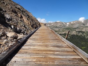
The walk to the trestles was easy and short from this end. The first one we saw was the curved trestle, and it was very impressive. The ground was very far below us, and the trestle was still extremely stable. It would probably still support the weight of vehicles, if the trail was still available to them.

We walked just a bit further to the straight trestle and found another sturdy one. The views were just as impressive.

Monica wanted to walk all the way back and she was just a passenger on this trip, so the others headed back to the Jeeps while she kept walking. The others went back on Boulder Wagon Road. Surprisingly, Monica beat the others back to the parking area by almost 20 minutes.

After we regrouped we headed back down the trail. It was a pretty quick trip to the highway and over to Byers Peak. This was a fantastic trail, and we need to spend more time in the area to explore all of the spurs.

above_riflesight_notch
airing_down
alternate_road_to_rollins_pass_east_closed
big_trees
blue_skies
boulder_wagon_road_start
camping_sign
closed_trail_around_riflesight_notch
curved_trestle_part_1
curved_trestle_part_2
curved_trestle_part_3
curved_trestle_part_4
curved_trestle_part_5
curved_trestle_part_6
curved_trestle_part_7
curved_trestle_part_8
curved_trestle_part_9
deer_part_1
deer_part_2
deer_part_3
don_above_needle_eye_tunnel
don_and_michael_down_from_above_needle_eye_tunnel
down_boulder_wagon_road
first_parking_area
forest_service_road_128
gate_at_close_end_of_hike_to_trestles
gate_at_far_end_of_trestles
gate_near_straight_trestle
hike_to_trestles_part_1
hike_to_trestles_part_2
hike_to_trestles_part_3
hike_to_trestles_part_4
hike_to_trestles_part_5
hike_to_trestles_part_6
hiking_trail_to_trestles
hotel_roof_part_1
hotel_roof_part_2
hotel_roof_part_3
indian_peaks_hiking_trail
james_peak_protection_area_sign
lunch
marmot
moffat_road_hill_route_sign
mountain_view
needle_eye_tunnel_closed
needle_eye_tunnel_gate
needle_eye_tunnel_part_1
needle_eye_tunnel_part_2
needle_eye_tunnel_part_3
needle_eye_tunnel_part_4
needle_eye_tunnel_warning_sign
old_road_to_rollins_pass_east
old_sign_near_trestles
open_trail
over_boulder_wagon_road
parked_below_riflesight_notch_trestle
parked
pumphouse_lake_part_1
pumphouse_lake_part_2
pumphouse_lake_part_3
riflesight_notch_trestle_part_1
riflesight_notch_trestle_part_2
riflesight_notch_trestle_part_3
riflesight_notch_trestle_part_4
riflesight_notch_trestle_part_5
riflesight_notch_trestle_part_6
riflesight_notch_trestle_part_7
riflesight_notch_trestle_part_8
riflesight_notch_trestle_part_9
rogers_pass_hiking_trail_sign
rollins_pass_sign_1
rollins_pass_sign_2
second_parking_area
shadows
short_hike
sign_along_hike_to_trestles
sign_at_trailhead_1
sign_at_trailhead_2
sign_for_149_5b
snow
spur_149_5b
spur_road
start_of_the_trail
straight_trestle_part_1
straight_trestle_part_2
straight_trestle_part_3
straight_trestle_part_4
through_jeeps
timberline
top_of_boulder_wagon_road
trail_above_timberline
valley_view
walk_to_needle_eye_tunnel
walt_hiking_to_trestles
warning_sign_1
warning_sign_2
waterfall
wide_trail
wild_flowers
winter_park
woodland_mountain
yankee_doodle_lake

Reports from Other Days: 3

Use the arrows or dots to flip through the previews of the other reports for Rollins Pass West. Click one of them to read more and see all of the photos from that day.

August 27, 2016

Led by Monica I.
The summer was ending with a bang, and other parts of Colorado were seeing their first snow of this winter. We were lucky and it didn’t snow where we were, but it was very cold and windy at the end of the trail. The skies were sunny, though, and we…
»
  • 1
  • 2
  • 3
Join Us!
If you aren’t a Member or Subscriber, you can’t see all of the content on this site. Get membership information to see why this site is best when you join and log in

Information for Subscribers

When you log in you’ll see more information here:

  • Recent Community Forum posts
  • Recent polls
  • Upcoming Events you can attend
  • Links to online users

© 2000-2022 · TrailDamage.com · Terms and Conditions · About · Contact
Trail information is only accurate on the date posted. Trails may have changed or closed since that date. Use this information for historical purposes only.
Contact the Forest Service or Bureau of Land Management for up-to-date trail information.

/* ----------------------------------------- */ /* View slug: reports-other-reports-for-same-trail-slider - start */ /* ----------------------------------------- */ /* place the prev/next controls on the sides */ .td-transition-controls .wpv-filter-next-link, .td-transition-controls .wpv-filter-previous-link { border: none; font-size: 300%; position: absolute; top: 70px; } .td-transition-controls .wpv-filter-previous-link { left: 0; } .td-transition-controls .wpv-filter-next-link { right: 0; } /* center the page selector horizonatally */ .td-transition-controls ul.wpv_pagination_dots { text-align: center; margin-top: 10px; } /* center the page selector horizonatally */ .td-transition-controls ul.wpv_pagination_dots li.wpv_pagination_dots_item, .td-transition-controls .wpv_pagination_dots li a { display: inline-block; float: none; } /* remove the default styles */ .td-transition-controls .wpv_pagination_dots li a { text-decoration: none; border-bottom: none; } .td-slider-container { padding: 0 25px; margin-bottom: 20px; position: relative; width:100%; display:table; } .td-slides { position: relative; } .td-slides-image { float:left; display:table-cell; } .td-slides-image img { border:1px solid #c0c0c0; } .td-slides-content { padding:4px 4px 4px 10px; border-top:1px solid #c0c0c0; border-right:1px solid #c0c0c0; border-bottom:1px solid #c0c0c0; display:table-cell; height:227px; overflow:hidden; } .td-slides-content h3 { margin-top:8px; } .td-slides-leader { font-size:smaller; margin-top:4px; } /* ----------------------------------------- */ /* View slug: reports-other-reports-for-same-trail-slider - end */ /* ----------------------------------------- */
/* ----------------------------------------- */ /* Content Template: Template for a Single Report - start */ /* ----------------------------------------- */ .entry-header { display:none; } .entry-content h1 { margin-top:16px; padding-top:0; } h1 a { color:#222; } h1 a:hover { color:#666; } p.entry-meta { font-size:small; } #report-body-spacer { clear:both; width:100%; height:20px; } #addtoany-bar { margin-bottom:2em; text-align:center; } .category-reports .post-info .author, .post-info .date { display: none; } .addthis_recommended_horizontal { text-align:center !important; } /* ----------------------------------------- */ /* Content Template: Template for a Single Report - end */ /* ----------------------------------------- */ /* ----------------------------------------- */ /* Content Template: Loop item in REPORTS Runners - start */ /* ----------------------------------------- */ #runners-container { width:100%; clear:both; } .runner { border:1px solid #c0c0c0; margin:0 6px 6px 0; float:left; width:49%; height:81px; } .runner-image { float: left; } .runner-image img { margin:2px 10px 0 2px; height:75px; width:75px; } .runner-name { text-transform:uppercase; } .runner-name a { color:#222; } .runner-name a:hover { color:#666; } .runner-vehicle { font-size:small; } @media only screen and (max-width: 768px) { .runner { width:100%; } } /* ----------------------------------------- */ /* Content Template: Loop item in REPORTS Runners - end */ /* ----------------------------------------- */