TrailDamage.com

Photos, videos and information about 4x4 trails in Colorado and Utah

  • Trails
    • Colorado
    • Utah
  • Reports
    • Featured Photos
    • Featured Videos
    • Reports Calendar
  • Members
  • Search
  • Trail Damage Winners
  • FAQ
  • Community
  • Upcoming Events
  • Membership
  • Log In
  • Facebook
  • Instagram
  • RSS
  • Twitter
  • YouTube

Rock Creek 100814

August 14, 2010 by Ladd Gillies

Rock Creek

Trail Run on August 14, 2010
Report and photos by Ladd G., Trail Leader
View trail information for Rock Creek

Mike C.
Red 2012 Jeep Wrangler Unlimited Rubicon
Ladd G.
Green 2003 Jeep Wrangler Rubicon
Bob R.
Green 2003 Jeep Wrangler Rubicon
Chad S.
Blue 2004 Jeep Wrangler

We ran three trails, and all of them were near Allenspark. We started with Rock Creek. The combination of trails was a fun one, as the trails are close to each other and quite different from each other. We'd recommend this combo for a nice day of varied wheeling. If you start at Rock Creek, then do Bright Trail, and then finish with Ironclads you work your way back toward the town of Lyons.

Rock Creek is a fun trail. There were just four Jeeps in our group so we made good time. Chad had some friends with him who were all from St. Louis and visiting Colorado.

We took the southern entrance onto Highway 7 and stopped at Crystal Springs to fill up water bottles. It is on the west side of the highway, where there is a parking lot across the way with plenty of room for several jeeps.

Continuing north a short way on the road we found Ski Road, but the sign is much easier to see coming in from the north. We took it very slowly through the residential area. The road twists a bit but the main road is pretty easy to see. Once we got out of the residential area we aired down and disconnected sway bars. We expected a pretty mild trail, so Mike and Chad kept their tires pretty full of air at that point. That changed once we got deeper into the trail!

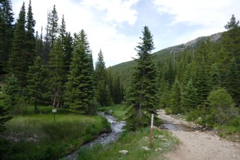
We found the first turnoff to the right where we think the entrance to the old ski area was, but we saw no trace of the old slopes. The first section was pretty smooth with lots of campers, dogs and kids. We saw a lot of good campsites. The creek is nice along here.

As we climbed up farther, the campsites got more sparse and there were a lot fewer people. The trail got steeper and bumpier. We were the only ones on the trail on the way up.

We spotted some isolated campsites up near the end of the trail that looked like good spots to come back to visit. The site at the end was pretty big and well above the creek. It wasn't particularly scenic as it was in the trees, but it was a nice spot to hang out. Because the trail was rockier than expected, Chad and Mike aired down more at the top to smooth out the ride back down.

Heading back down we met up with two vehicles that must have come out of one off the cutoffs along the trail. They looked like they were looking for a campsite. We passed them and finished the trail. Then we headed down the road to Bright Trail.

airing_down_part_1
airing_down_part_2
airing_down_part_3
at_the_end
bob_has_a_new_mod
chad_and_mike
closed_section
jeeps
ladd_on_the_trail
ski_road_sign
trail_sign

Reports from Other Days: 3

Use the arrows or dots to flip through the previews of the other reports for Rock Creek. Click one of them to read more and see all of the photos from that day.

June 27, 2020

Led by Monica I.
We came off of a great time on Johnny Park Road to a few miles of pavement to get to Rock Creek.  Johnny Park ended up being more challenging than it was the last time we were there, and Rock Creek ended up being less challenging. Even though coronavirus restrictions…
»
  • 1
  • 2
  • 3
Join Us!
If you aren’t a Member or Subscriber, you can’t see all of the content on this site. Get membership information to see why this site is best when you join and log in

Information for Subscribers

When you log in you’ll see more information here:

  • Recent Community Forum posts
  • Recent polls
  • Upcoming Events you can attend
  • Links to online users

© 2000-2023 · TrailDamage.com · Terms and Conditions · About · Contact
Trail information is only accurate on the date posted. Trails may have changed or closed since that date. Use this information for historical purposes only.
Contact the Forest Service or Bureau of Land Management for up-to-date trail information.

/* ----------------------------------------- */ /* View slug: reports-other-reports-for-same-trail-slider - start */ /* ----------------------------------------- */ /* place the prev/next controls on the sides */ .td-transition-controls .wpv-filter-next-link, .td-transition-controls .wpv-filter-previous-link { border: none; font-size: 300%; position: absolute; top: 70px; } .td-transition-controls .wpv-filter-previous-link { left: 0; } .td-transition-controls .wpv-filter-next-link { right: 0; } /* center the page selector horizonatally */ .td-transition-controls ul.wpv_pagination_dots { text-align: center; margin-top: 10px; } /* center the page selector horizonatally */ .td-transition-controls ul.wpv_pagination_dots li.wpv_pagination_dots_item, .td-transition-controls .wpv_pagination_dots li a { display: inline-block; float: none; } /* remove the default styles */ .td-transition-controls .wpv_pagination_dots li a { text-decoration: none; border-bottom: none; } .td-slider-container { padding: 0 25px; margin-bottom: 20px; position: relative; width:100%; display:table; } .td-slides { position: relative; } .td-slides-image { float:left; display:table-cell; } .td-slides-image img { border:1px solid #c0c0c0; } .td-slides-content { padding:4px 4px 4px 10px; border-top:1px solid #c0c0c0; border-right:1px solid #c0c0c0; border-bottom:1px solid #c0c0c0; display:table-cell; height:227px; overflow:hidden; } .td-slides-content h3 { margin-top:8px; } .td-slides-leader { font-size:smaller; margin-top:4px; } /* ----------------------------------------- */ /* View slug: reports-other-reports-for-same-trail-slider - end */ /* ----------------------------------------- */
/* ----------------------------------------- */ /* Content Template: Template for a Single Report - start */ /* ----------------------------------------- */ .entry-header { display:none; } .entry-content h1 { margin-top:16px; padding-top:0; } h1 a { color:#222; } h1 a:hover { color:#666; } p.entry-meta { font-size:small; } #report-body-spacer { clear:both; width:100%; height:20px; } #addtoany-bar { margin-bottom:2em; text-align:center; } .category-reports .post-info .author, .post-info .date { display: none; } .addthis_recommended_horizontal { text-align:center !important; } /* ----------------------------------------- */ /* Content Template: Template for a Single Report - end */ /* ----------------------------------------- */ /* ----------------------------------------- */ /* Content Template: Loop item in REPORTS Runners - start */ /* ----------------------------------------- */ #runners-container { width:100%; clear:both; } .runner { border:1px solid #c0c0c0; margin:0 6px 6px 0; float:left; width:49%; height:81px; } .runner-image { float: left; } .runner-image img { margin:2px 10px 0 2px; height:75px; width:75px; } .runner-name { text-transform:uppercase; } .runner-name a { color:#222; } .runner-name a:hover { color:#666; } .runner-vehicle { font-size:small; } @media only screen and (max-width: 768px) { .runner { width:100%; } } /* ----------------------------------------- */ /* Content Template: Loop item in REPORTS Runners - end */ /* ----------------------------------------- */