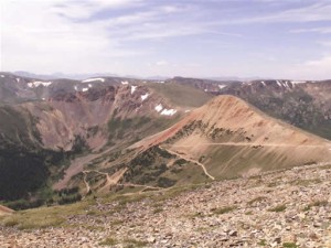
TrailDamage.com

Photos, videos and information about 4x4 trails in Colorado and Utah

  • Trails
    • Colorado
    • Utah
  • Reports
    • Featured Videos
    • Reports Calendar
  • Members
  • Search
  • Trail Damage Winners
  • FAQ
  • Community
  • Upcoming Events
  • Membership
  • Log In
  • Facebook
  • Instagram
  • RSS
  • Twitter
  • YouTube

Red Cone 030719

July 19, 2003 by Monica

Red Cone

Trail Run on July 19, 2003
Report and photos by Monica I., Trail Leader
View trail information for Red Cone

Perry S.
Purple 1994 Ford Explorer
Mike S.
Silver 2002 Jeep Wrangler
Dan
Green 2000 Jeep Wrangler
Bob S.
Green 1997 Jeep Wrangler
Jane
Red 1999 Jeep Wrangler
Jenn L.
Yellow 2001 Jeep Wrangler
Tom B.
White 1998 Jeep Wrangler
Monica I.
Red 2010 Jeep Wrangler Rubicon

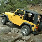
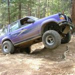
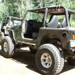
Red Cone is a scary trail but a great one for stock vehicles and those just starting out on moderate to difficult trails. We had everything from Jane's stock TJ to Perry's beefy Ford Explorer so we had a little of everything. No one got into any trouble and everyone had a good time (even Jenn on her crutches as a passenger)!

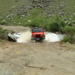
We started out on time and Bob actually saw our group on Highway 285 and managed to catch up with us (he'd gone past Conifer and was waiting in Bailey). We started the trail and Jane's stock TJ did really well on all of the rocky obstacles. Nice driving! The weather was decent (a little cloudy) and no one had even a tiny bit of vehicle issues.

The first hill had a lot of Whoopdeedoos in it this year, where the dirt is really red. The second hill was also pretty wavy. The third hill was steep but pretty mellow. We all came down smiling.

Radical Hill was still closed due to snow so we went out using the north end of Webster Pass. We had lunch in that gorgeous meadow where Radical Hill and Webster Pass meet -- Perry and his group brought an impressive picnic of food and patio furniture. The run was fun as it always is. Red Cone is a really fun trail!

big_hill
bob_and_tom_down_red_cone
bob_through_the_water_part_1
bob_through_the_water_part_2
bob_through_the_water_part_3
break_time
checking_out_the_scenery
chilly_tundra
coming_down_red_cone
coming_down_the_third_hill
dan_at_the_start
dan_perry_and_bob_down_red_cone
far_off_mountains
jane_after_the_water
jane_at_the_start
jane_down_red_cone
jane_in_the_wet_jeep
jane_perry_and_bob
jane_through_the_water_part_1
jane_through_the_water_part_2
jenn_riding_with_monica
just_after_the_big_hill
lamping_creek
line_up
lots_of_trail
lunch_in_the_meadow
lunch_part_1
lunch_part_2
lunch_part_3
lunch_part_4
lunch_part_5
lunch_part_6
lunch_part_7
lunch_part_8
lunch_part_9
mellow_trail
mike_and_bob
mike_and_dan_on_the_trail
mike_and_jane_down_red_cone
mike_and_scenery
mike_down_red_cone
mike_hanging_out
mike_through_the_water
monica_down_red_cone_part_1
monica_down_red_cone_part_2
monica_down_red_cone_part_3
monica_down_red_cone_part_4
monica_down_the_third_hill
more_hills_after_the_big_one
north_webster_pass
perry_and_bob_down_the_third_hill
perry_and_mike_on_the_way_out
perry_bob_and_tom_down_red_cone_part_1
perry_bob_and_tom_down_red_cone_part_2
perry_bob_and_tom_down_the_second_hill
perry_through_the_water_part_1
perry_through_the_water_part_2
red_cone_from_the_far_side
red_cone_hill
red_cone_trail
red_cone
snow_and_green
snow_in_july
snow_in_the_distance
south_side_of_webster_pass
start_of_the_trail
timberline
tom_down_the_switchbacks
tom_is_okay
tom_on_the_trail
tom_up_some_big_rocks_part_1
tom_up_some_big_rocks_part_2
webster_pass
where_webster_pass_and_red_cone_intersect

Reports from Other Days: 6

Use the arrows or dots to flip through the previews of the other reports for Red Cone. Click one of them to read more and see all of the photos from that day.

September 14, 2002

Led by Monica I.
We did this high pass before Radical Hill, as the trails run together. This is one of the "Holy Grail" trails of Colorado, with very steep hills of loose rock and dirt that are only passable going downhill. We took a lot of scenery shots this time, rather than the…
«
  • 1
  • 2
  • 3
  • 4
  • 5
  • 6
Join Us!
If you aren’t a Member or Subscriber, you can’t see all of the content on this site. Get membership information to see why this site is best when you join and log in

Information for Subscribers

When you log in you’ll see more information here:

  • Recent Community Forum posts
  • Recent polls
  • Upcoming Events you can attend
  • Links to online users

© 2000-2019 · TrailDamage.com · Terms and Conditions · About · Contact
Trail information is only accurate on the date posted. Trails may have changed or closed since that date. Use this information for historical purposes only.
Contact the Forest Service or Bureau of Land Management for up-to-date trail information.

/* ----------------------------------------- */ /* View slug: reports-other-reports-for-same-trail-slider - start */ /* ----------------------------------------- */ /* place the prev/next controls on the sides */ .td-transition-controls .wpv-filter-next-link, .td-transition-controls .wpv-filter-previous-link { border: none; font-size: 300%; position: absolute; top: 70px; } .td-transition-controls .wpv-filter-previous-link { left: 0; } .td-transition-controls .wpv-filter-next-link { right: 0; } /* center the page selector horizonatally */ .td-transition-controls ul.wpv_pagination_dots { text-align: center; margin-top: 10px; } /* center the page selector horizonatally */ .td-transition-controls ul.wpv_pagination_dots li.wpv_pagination_dots_item, .td-transition-controls .wpv_pagination_dots li a { display: inline-block; float: none; } /* remove the default styles */ .td-transition-controls .wpv_pagination_dots li a { text-decoration: none; border-bottom: none; } .td-slider-container { padding: 0 25px; margin-bottom: 20px; position: relative; width:100%; display:table; } .td-slides { position: relative; } .td-slides-image { float:left; display:table-cell; } .td-slides-image img { border:1px solid #c0c0c0; } .td-slides-content { padding:4px 4px 4px 10px; border-top:1px solid #c0c0c0; border-right:1px solid #c0c0c0; border-bottom:1px solid #c0c0c0; display:table-cell; height:227px; overflow:hidden; } .td-slides-content h3 { margin-top:8px; } .td-slides-leader { font-size:smaller; margin-top:4px; } /* ----------------------------------------- */ /* View slug: reports-other-reports-for-same-trail-slider - end */ /* ----------------------------------------- */
/* ----------------------------------------- */ /* Content Template: Template for a Single Report - start */ /* ----------------------------------------- */ .entry-header { display:none; } .entry-content h1 { margin-top:16px; padding-top:0; } h1 a { color:#222; } h1 a:hover { color:#666; } p.entry-meta { font-size:small; } #report-body-spacer { clear:both; width:100%; height:20px; } #addtoany-bar { margin-bottom:2em; text-align:center; } .category-reports .post-info .author, .post-info .date { display: none; } .addthis_recommended_horizontal { text-align:center !important; } /* ----------------------------------------- */ /* Content Template: Template for a Single Report - end */ /* ----------------------------------------- */ /* ----------------------------------------- */ /* Content Template: Loop item in REPORTS Runners - start */ /* ----------------------------------------- */ #runners-container { width:100%; clear:both; } .runner { border:1px solid #c0c0c0; margin:0 6px 6px 0; float:left; width:49%; height:81px; } .runner-image { float: left; } .runner-image img { margin:2px 10px 0 2px; height:75px; width:75px; } .runner-name { text-transform:uppercase; } .runner-name a { color:#222; } .runner-name a:hover { color:#666; } .runner-vehicle { font-size:small; } @media only screen and (max-width: 768px) { .runner { width:100%; } } /* ----------------------------------------- */ /* Content Template: Loop item in REPORTS Runners - end */ /* ----------------------------------------- */