TrailDamage.com

Photos, videos and information about 4x4 trails in Colorado and Utah

  • Trails
    • Colorado
    • Utah
  • Reports
    • Featured Photos
    • Featured Videos
    • Reports Calendar
  • Members
  • Search
  • Trail Damage Winners
  • FAQ
  • Community
  • Upcoming Events
  • Membership
  • Log In
  • Facebook
  • Instagram
  • RSS
  • Twitter
  • YouTube

Poughkeepsie Gulch 040820

August 20, 2004 by Monica

Poughkeepsie Gulch

Trail Run on August 20, 2004
Report and photos by Monica I., Trail Leader
View trail information for Poughkeepsie Gulch

Bob S.
Green 1997 Jeep Wrangler
Ladd G.
Green 2003 Jeep Wrangler Rubicon
Mike S.
Silver 2002 Jeep Wrangler
Mike C.
Red 2012 Jeep Wrangler Unlimited Rubicon
Monica I.
Red 2010 Jeep Wrangler Rubicon
Brian E.
White 1998 Jeep Wrangler
Aaron N.
Maroon 2003 Jeep Wrangler Rubicon

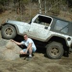
This trail was a blast even though it took us quite awhile to run it and only Aaron made it through the difficult section of the obstacle. I'm sure it's a trail we'll run every time we're in Ouray.

We started out splashing through the big mud puddle at the trailhead (of course) and though it wasn't very deep it was pretty big so we got some good splashing in.

It started out in the trees and the trail was one mud puddle after another. It wasn't long before we saw an optional obstacle off to the right of the trail. It didn't go anywhere but it looked like fun so Mike S. drove up to it to check it out.

It was a steep wall of rock with mud and dirt at the bottom. He backed up right away and didn't attempt it. Bob was next and he tried but the mud made it impossible. Aaron gave it a few tries after Bob gave up and he couldn't make it either. It was just too wet. This obstacle would be nearly impossible unless you were in a very well-equipped buggy and it was dry.

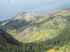
We continued on the trail and passed some beautiful wildflowers and waterfalls. It wasn't long before we were up the rocky hill and around the corner before the big obstacle.

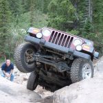
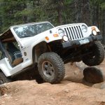
We came around the corner and found another large group of vehicles at the bottom, with a couple vehicles at the top. At the bottom of the right side of the obstacle was a truck with its right, passenger side pretty caved in. They were using a Hi-Lift Jack to try to pry the cab open so it would once again match the passenger door. It turned out they were trying the right-most line and slipped their driver's front tire into the crack. After that they rolled to the bottom. No one was hurt and eventually they got it running again.

Monica tried to straddle the crack of the obstacle on the right and just spun in the mud and dirt. It was impossible to stay straight and she slid all over the rock. She moved over to the middle rock where the "V" is and tried that a couple of times, but that wasn't happening either. She eventually backed down to the bottom again.

Aaron gave the right-most line a few tries as well as the rest of the other group floored it and ran up the left-most dirt hill. The dirt was loose and even that line was hard. Aaron had to move off of the obstacle so the vehicles at the top could winch the injured truck to the top. After that, Aaron made it through the middle of the obstacle without a tow strap or winch. He was the only one!

Everyone else made it successfully up the left-most line, though almost everyone had to wrestle with it.

When we worked our way down from the obstacle and saw Lake Como it was too bad we didn't have more time. The lake was absolutely beautiful and it would have been nice to stop and check it out.

We passed the lake and headed up California Gulch. What a great trail! This is one of those trails that not too many vehicles can conquer, which always makes it fun.

aaron_at_the_entrance
aaron_mike_s_and_brian
aaron_on_the_obstacle_part_1
aaron_on_the_obstacle_part_2
aaron_on_the_obstacle_part_3
aaron_on_the_obstacle_part_4
aaron_on_the_obstacle_part_5
aaron_on_the_obstacle_part_7
aaron_on_the_side_obstacle_part_1
aaron_on_the_side_obstacle_part_2
aaron_on_the_side_obstacle_part_3
aaron_on_the_trail
aaron_trail_damage
after_the_obstacle
at_the_entrance
biggest_obstacle
blue_sky
bob_at_the_entrance_part_1
bob_at_the_entrance_part_2
bob_at_the_entrance_part_3
bob_at_the_obstacle
bob_mike_s_and_brian
bob_on_the_side_obstacle_part_1
bob_on_the_side_obstacle_part_2
brian_at_the_obstacle
brian_on_the_obstacle_hill_part_1
brian_on_the_obstacle_hill_part_2
climbing
creekside
curve_before_the_obstacle
deer
early_trail
everyone_at_the_top_of_the_obstacle
everyone_on_the_trail
fields_of_flowers
gorgeous_view
green
ladd_at_the_entrance_part_1
ladd_at_the_entrance_part_2
ladd_at_the_entrance_part_3
ladd_on_the_obstacle_hill_part_1
ladd_on_the_obstacle_hill_part_2
ladd_on_the_obstacle_hill_part_3
lake_como_part_1
lake_como_part_2
lake_como_part_3
marmot
mike_c_and_monica
mike_c_at_the_obstacle
mike_s_and_brian
mike_s_on_the_obstacle_hill
mike_s_on_the_trail
mine_shaft
monica_at_another_obstacle_section
monica_on_the_obstacle
monica_on_the_trail
mountain_scenery
network_of_trails
rock_hill
rock_obstacle
rocky_trail
running_water
side_obstacle
sign_number_1
sign_number_2
small_waterfall
start_of_the_trail
tailings
the_obstacle
trail_in_the_meadow
trail_next_to_the_river
trail_to_the_obstacle
tuttle_mountain
uncompahgre_river
view_from_the_obstacle
waiting_at_the_obstacle
waterfall
white_rocks
wildflowers

Reports from Other Days: 2

Use the arrows or dots to flip through the previews of the other reports for Poughkeepsie Gulch. Click one of them to read more and see all of the photos from that day.

September 20, 2014

Led by Roger R.
We had already completed four trails when we got to the upper end and trailhead for Poughkeepsie Gulch. We were running this trail downhill because we anticipated rain for a good share of the day, but the rain never materialized. In any case, we did not want to be winching…
»
  • 1
  • 2
Join Us!
If you aren’t a Member or Subscriber, you can’t see all of the content on this site. Get membership information to see why this site is best when you join and log in

Information for Subscribers

When you log in you’ll see more information here:

  • Recent Community Forum posts
  • Recent polls
  • Upcoming Events you can attend
  • Links to online users

© 2000-2023 · TrailDamage.com · Terms and Conditions · About · Contact
Trail information is only accurate on the date posted. Trails may have changed or closed since that date. Use this information for historical purposes only.
Contact the Forest Service or Bureau of Land Management for up-to-date trail information.

/* ----------------------------------------- */ /* View slug: reports-other-reports-for-same-trail-slider - start */ /* ----------------------------------------- */ /* place the prev/next controls on the sides */ .td-transition-controls .wpv-filter-next-link, .td-transition-controls .wpv-filter-previous-link { border: none; font-size: 300%; position: absolute; top: 70px; } .td-transition-controls .wpv-filter-previous-link { left: 0; } .td-transition-controls .wpv-filter-next-link { right: 0; } /* center the page selector horizonatally */ .td-transition-controls ul.wpv_pagination_dots { text-align: center; margin-top: 10px; } /* center the page selector horizonatally */ .td-transition-controls ul.wpv_pagination_dots li.wpv_pagination_dots_item, .td-transition-controls .wpv_pagination_dots li a { display: inline-block; float: none; } /* remove the default styles */ .td-transition-controls .wpv_pagination_dots li a { text-decoration: none; border-bottom: none; } .td-slider-container { padding: 0 25px; margin-bottom: 20px; position: relative; width:100%; display:table; } .td-slides { position: relative; } .td-slides-image { float:left; display:table-cell; } .td-slides-image img { border:1px solid #c0c0c0; } .td-slides-content { padding:4px 4px 4px 10px; border-top:1px solid #c0c0c0; border-right:1px solid #c0c0c0; border-bottom:1px solid #c0c0c0; display:table-cell; height:227px; overflow:hidden; } .td-slides-content h3 { margin-top:8px; } .td-slides-leader { font-size:smaller; margin-top:4px; } /* ----------------------------------------- */ /* View slug: reports-other-reports-for-same-trail-slider - end */ /* ----------------------------------------- */
/* ----------------------------------------- */ /* Content Template: Template for a Single Report - start */ /* ----------------------------------------- */ .entry-header { display:none; } .entry-content h1 { margin-top:16px; padding-top:0; } h1 a { color:#222; } h1 a:hover { color:#666; } p.entry-meta { font-size:small; } #report-body-spacer { clear:both; width:100%; height:20px; } #addtoany-bar { margin-bottom:2em; text-align:center; } .category-reports .post-info .author, .post-info .date { display: none; } .addthis_recommended_horizontal { text-align:center !important; } /* ----------------------------------------- */ /* Content Template: Template for a Single Report - end */ /* ----------------------------------------- */ /* ----------------------------------------- */ /* Content Template: Loop item in REPORTS Runners - start */ /* ----------------------------------------- */ #runners-container { width:100%; clear:both; } .runner { border:1px solid #c0c0c0; margin:0 6px 6px 0; float:left; width:49%; height:81px; } .runner-image { float: left; } .runner-image img { margin:2px 10px 0 2px; height:75px; width:75px; } .runner-name { text-transform:uppercase; } .runner-name a { color:#222; } .runner-name a:hover { color:#666; } .runner-vehicle { font-size:small; } @media only screen and (max-width: 768px) { .runner { width:100%; } } /* ----------------------------------------- */ /* Content Template: Loop item in REPORTS Runners - end */ /* ----------------------------------------- */