TrailDamage.com

Photos, videos and information about 4x4 trails in Colorado and Utah

  • Trails
    • Colorado
    • Utah
  • Reports
    • Featured Photos
    • Featured Videos
    • Reports Calendar
  • Members
  • Search
  • Trail Damage Winners
  • FAQ
  • Community
  • Upcoming Events
  • Membership
  • Log In
  • Facebook
  • Instagram
  • RSS
  • Twitter
  • YouTube

Pole Hill 070716

July 16, 2007 by Jed Palmer

Pole Hill

Trail Run on July 16, 2007
Report and photos by Jed P., Trail Leader
View trail information for Pole Hill

Jed P.
Green 1998 Jeep Wrangler
Walt S.
Gray 2022 Jeep Wrangler Unlimited Rubicon 392

On June 30th, some of our group ran the loop made by Pole Hill, Pierson Park Road and Johnny Park Road, but Walt and Jed could not make that run. Not to be left out they decided to run it themselves on a different day. Just like on June 30th, the weather was perfect.

Even with good instructions and GPS coordinates we still made a wrong turn trying to find the trail. It didn't take very long for us to figure out our mistake -- we turned one street too soon. We worried that this wasn't a very good start, knowing that wrong turns could be abundant today. Luckily, it turned out that would be the only wrong turn of the whole run.

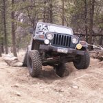
After making it to the trailhead, we aired down and started the trail. The trail started the first of many long rocky climbs right away. This is a great trail for long climbs through the woods.

There are many camping spots along the trail. Jed wanted to check a few out and at the first one we stopped at had all sorts of trash on the ground. Jed picked up all the trash and we took off to explore some more.

At the first intersection we stopped and consulted the instructions and GPS which were very valuable tools for this trail. We would be stopping to do this at every intersection through out the day, but we didn't make any more wrong turns. Seeing that this was 247A, we went to the next intersection and turned right on 247. A left here will take you to a campground. We were treated to another hill climb through the trees.

We made a left on 247C and went straight past 122A on our left. This time we climbed a steeper hill and the road became 247 again to finish a nice loop back to 247C. We turned right again and then turned left onto 122A to head to the Notch.

We headed down into a valley and across Solitude Creek. Don't blink or you might miss the little creek. A little while after crossing Solitude Creek we started climbing another nice hill. Seems like this whole trail is uphill. We checked out another campground and then headed to the overlook the see the view. Walt was really looking forward to seeing the Notch, so off we went.

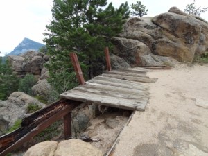
We arrived at the Notch and climbed to the top to take a few pictures. You have a great view of Estes Park from the top of the rocks. The view isn't bad at the Notch either. We shot the breeze for awhile, but it was time to head down the trail. We still had two more to do to finish the loop.

We had no problems finding our way down off the trail. On to Pierson Park Road!

airing_down_part_1
airing_down_part_2
around_a_bend
forest_service_sign
jed_at_a_campsite
jed_at_the_notch_part_1
jed_at_the_notch_part_2
jed_on_larger_rocks_part_1
jed_on_larger_rocks_part_2
jed_on_smaller_rocks_part_1
jed_on_smaller_rocks_part_2
jed_picking_up_trash
road_closed
smooth_trail_through_trees
start_of_the_trail
trail_before_the_notch
view_from_the_campsite
view_from_the_notch_part_1
view_from_the_notch_part_2
walt_at_the_notch_part_1
walt_at_the_notch_part_2
walt_on_smaller_rocks_part_1
walt_on_smaller_rocks_part_2

Reports from Other Days: 2

Use the arrows or dots to flip through the previews of the other reports for Pole Hill. Click one of them to read more and see all of the photos from that day.

July 7, 2012

Led by Monica I.
It had been a long time since we’d been on Pole Hill and we were looking forward to a revisit. We finished the uneventful Hell Canyon Road trail and Pole Hill was just up the road. We found the trailhead easily enough and didn’t stop. There were lots of cars…
»
  • 1
  • 2
Join Us!
If you aren’t a Member or Subscriber, you can’t see all of the content on this site. Get membership information to see why this site is best when you join and log in

Information for Subscribers

When you log in you’ll see more information here:

  • Recent Community Forum posts
  • Recent polls
  • Upcoming Events you can attend
  • Links to online users

© 2000-2023 · TrailDamage.com · Terms and Conditions · About · Contact
Trail information is only accurate on the date posted. Trails may have changed or closed since that date. Use this information for historical purposes only.
Contact the Forest Service or Bureau of Land Management for up-to-date trail information.

/* ----------------------------------------- */ /* View slug: reports-other-reports-for-same-trail-slider - start */ /* ----------------------------------------- */ /* place the prev/next controls on the sides */ .td-transition-controls .wpv-filter-next-link, .td-transition-controls .wpv-filter-previous-link { border: none; font-size: 300%; position: absolute; top: 70px; } .td-transition-controls .wpv-filter-previous-link { left: 0; } .td-transition-controls .wpv-filter-next-link { right: 0; } /* center the page selector horizonatally */ .td-transition-controls ul.wpv_pagination_dots { text-align: center; margin-top: 10px; } /* center the page selector horizonatally */ .td-transition-controls ul.wpv_pagination_dots li.wpv_pagination_dots_item, .td-transition-controls .wpv_pagination_dots li a { display: inline-block; float: none; } /* remove the default styles */ .td-transition-controls .wpv_pagination_dots li a { text-decoration: none; border-bottom: none; } .td-slider-container { padding: 0 25px; margin-bottom: 20px; position: relative; width:100%; display:table; } .td-slides { position: relative; } .td-slides-image { float:left; display:table-cell; } .td-slides-image img { border:1px solid #c0c0c0; } .td-slides-content { padding:4px 4px 4px 10px; border-top:1px solid #c0c0c0; border-right:1px solid #c0c0c0; border-bottom:1px solid #c0c0c0; display:table-cell; height:227px; overflow:hidden; } .td-slides-content h3 { margin-top:8px; } .td-slides-leader { font-size:smaller; margin-top:4px; } /* ----------------------------------------- */ /* View slug: reports-other-reports-for-same-trail-slider - end */ /* ----------------------------------------- */
/* ----------------------------------------- */ /* Content Template: Template for a Single Report - start */ /* ----------------------------------------- */ .entry-header { display:none; } .entry-content h1 { margin-top:16px; padding-top:0; } h1 a { color:#222; } h1 a:hover { color:#666; } p.entry-meta { font-size:small; } #report-body-spacer { clear:both; width:100%; height:20px; } #addtoany-bar { margin-bottom:2em; text-align:center; } .category-reports .post-info .author, .post-info .date { display: none; } .addthis_recommended_horizontal { text-align:center !important; } /* ----------------------------------------- */ /* Content Template: Template for a Single Report - end */ /* ----------------------------------------- */ /* ----------------------------------------- */ /* Content Template: Loop item in REPORTS Runners - start */ /* ----------------------------------------- */ #runners-container { width:100%; clear:both; } .runner { border:1px solid #c0c0c0; margin:0 6px 6px 0; float:left; width:49%; height:81px; } .runner-image { float: left; } .runner-image img { margin:2px 10px 0 2px; height:75px; width:75px; } .runner-name { text-transform:uppercase; } .runner-name a { color:#222; } .runner-name a:hover { color:#666; } .runner-vehicle { font-size:small; } @media only screen and (max-width: 768px) { .runner { width:100%; } } /* ----------------------------------------- */ /* Content Template: Loop item in REPORTS Runners - end */ /* ----------------------------------------- */