TrailDamage.com

Photos, videos and information about 4x4 trails in Colorado and Utah

  • Trails
    • Colorado
    • Utah
  • Reports
    • Featured Photos
    • Featured Videos
    • Reports Calendar
  • Members
  • Search
  • Trail Damage Winners
  • FAQ
  • Community
  • Upcoming Events
  • Membership
  • Log In
  • Facebook
  • Instagram
  • RSS
  • Twitter
  • YouTube

Phantom Creek 070922

September 22, 2007 by Monica

Phantom Creek

Trail Run on September 22, 2007
Report and photos by Monica I., Trail Leader
View trail information for Phantom Creek

Monica I.
Red 2010 Jeep Wrangler Rubicon
Chad S.
Blue 2004 Jeep Wrangler
Todd S.
Silver 2005 Jeep Wrangler Unlimited Rubicon

We finished our day exploring the Hayman Fire burn area by doing the Phantom Creek loop. It was the easiest of the trails so far, and the busiest. There were lots of ATVs and dirt bikes, as well as a few vehicles.

A good portion of the ATV riders did not have helmets, and most were going too fast for the conditions. More than a few accidents must happen in this area, we guessed.

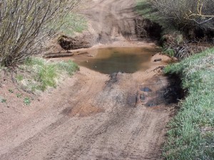
There were lots of people camping, settling in for their dinner as we passed. We started on the Phantom Creek Road side and were surprised to find that it wasn't burned there. The trees were green, which was a nice break from our day of sad, burned trees.

The trail got a little confusing toward the far end, but we eventually found the intersection with Manchester Creek. We planned on taking it as far as the gate. We saw the warning sign for the gate, but then when we got to the fencing the gate was gone. ATVs rode past us and there were signs of lots of traffic, so we continued on. Very soon we were at another sign facing the other way, mentioning another gate. We never saw a gate.

We continued for a bit, but then realized we'd be there all night if we kept exploring. We soon turned back, backtracking to the Phantom Creek intersection. There were way too many spurs to check out.

Once we got to Signal Butte Road, we saw the Hayman Fire burn. It must have stopped at the creek in this area. It looked like the rest of the terrain we had seen all day -- lots of tall, black, burned trees surrounded by short, yellow aspens. It was beautiful in an odd way. It was definitely the most interesting way to see the yellow trees.

It wasn't long before we were back at the big parking area. We aired up there and reconnected, and then headed out. Some of us went to dinner in Woodland Park on the way home, and everyone got home early (compared to the times we usually get home, anyway).

It was a great, mellow finish to a very interesting day.

aspens_part_1
aspens_part_2
blue_sky
break_time
bumpy
burned_trees
crack_in_the_trail
crossroads_parking_area
early_trail_sign
early_trail
far_end
manchester_creek_gate
manchester_creek_open_area
manchester_creek_start
manchester_creek_warning_sign
marshy_meadow
mellow_trail
open_area
phantom_creek_crossing
pikes_peak_part_1
pikes_peak_part_2
signal_butte_road
signal_butte

Reports from Other Days: 2

Use the arrows or dots to flip through the previews of the other reports for Phantom Creek. Click one of them to read more and see all of the photos from that day.

May 28, 2008

Led by Roger R.
We had just finished running Cedar Mountain Road with a trip down Metberry Gulch thrown in. It was time to do the last trail of the day, Phantom Creek. Finding the trailhead was easy since Walt had the tracks on his GPS already. We turned left onto the trail and…
«
  • 1
  • 2
Join Us!
If you aren’t a Member or Subscriber, you can’t see all of the content on this site. Get membership information to see why this site is best when you join and log in

Information for Subscribers

When you log in you’ll see more information here:

  • Recent Community Forum posts
  • Recent polls
  • Upcoming Events you can attend
  • Links to online users

© 2000-2022 · TrailDamage.com · Terms and Conditions · About · Contact
Trail information is only accurate on the date posted. Trails may have changed or closed since that date. Use this information for historical purposes only.
Contact the Forest Service or Bureau of Land Management for up-to-date trail information.

/* ----------------------------------------- */ /* View slug: reports-other-reports-for-same-trail-slider - start */ /* ----------------------------------------- */ /* place the prev/next controls on the sides */ .td-transition-controls .wpv-filter-next-link, .td-transition-controls .wpv-filter-previous-link { border: none; font-size: 300%; position: absolute; top: 70px; } .td-transition-controls .wpv-filter-previous-link { left: 0; } .td-transition-controls .wpv-filter-next-link { right: 0; } /* center the page selector horizonatally */ .td-transition-controls ul.wpv_pagination_dots { text-align: center; margin-top: 10px; } /* center the page selector horizonatally */ .td-transition-controls ul.wpv_pagination_dots li.wpv_pagination_dots_item, .td-transition-controls .wpv_pagination_dots li a { display: inline-block; float: none; } /* remove the default styles */ .td-transition-controls .wpv_pagination_dots li a { text-decoration: none; border-bottom: none; } .td-slider-container { padding: 0 25px; margin-bottom: 20px; position: relative; width:100%; display:table; } .td-slides { position: relative; } .td-slides-image { float:left; display:table-cell; } .td-slides-image img { border:1px solid #c0c0c0; } .td-slides-content { padding:4px 4px 4px 10px; border-top:1px solid #c0c0c0; border-right:1px solid #c0c0c0; border-bottom:1px solid #c0c0c0; display:table-cell; height:227px; overflow:hidden; } .td-slides-content h3 { margin-top:8px; } .td-slides-leader { font-size:smaller; margin-top:4px; } /* ----------------------------------------- */ /* View slug: reports-other-reports-for-same-trail-slider - end */ /* ----------------------------------------- */
/* ----------------------------------------- */ /* Content Template: Template for a Single Report - start */ /* ----------------------------------------- */ .entry-header { display:none; } .entry-content h1 { margin-top:16px; padding-top:0; } h1 a { color:#222; } h1 a:hover { color:#666; } p.entry-meta { font-size:small; } #report-body-spacer { clear:both; width:100%; height:20px; } #addtoany-bar { margin-bottom:2em; text-align:center; } .category-reports .post-info .author, .post-info .date { display: none; } .addthis_recommended_horizontal { text-align:center !important; } /* ----------------------------------------- */ /* Content Template: Template for a Single Report - end */ /* ----------------------------------------- */ /* ----------------------------------------- */ /* Content Template: Loop item in REPORTS Runners - start */ /* ----------------------------------------- */ #runners-container { width:100%; clear:both; } .runner { border:1px solid #c0c0c0; margin:0 6px 6px 0; float:left; width:49%; height:81px; } .runner-image { float: left; } .runner-image img { margin:2px 10px 0 2px; height:75px; width:75px; } .runner-name { text-transform:uppercase; } .runner-name a { color:#222; } .runner-name a:hover { color:#666; } .runner-vehicle { font-size:small; } @media only screen and (max-width: 768px) { .runner { width:100%; } } /* ----------------------------------------- */ /* Content Template: Loop item in REPORTS Runners - end */ /* ----------------------------------------- */