TrailDamage.com

Photos, videos and information about 4x4 trails in Colorado and Utah

  • Trails
    • Colorado
    • Utah
  • Reports
    • Featured Photos
    • Featured Videos
    • Reports Calendar
  • Members
  • Search
  • Trail Damage Winners
  • FAQ
  • Community
  • Upcoming Events
  • Membership
  • Log In
  • Facebook
  • Instagram
  • RSS
  • Twitter
  • YouTube

Pearl Pass 050904

September 4, 2005 by Monica

Pearl Pass

Trail Run on September 4, 2005
Report and photos by Monica I., Trail Leader
View trail information for Pearl Pass

Ladd G.
Green 2003 Jeep Wrangler Rubicon
Dave B.
Black 2004 Jeep Wrangler Rubicon
Monica I.
Red 2010 Jeep Wrangler Rubicon
Cheryl W.
Orange 2006 Jeep Wrangler Unlimited Rubicon
Micheal S.
Maroon 1988 Jeep Cherokee

We ran this trail as the last one in a series, making it out well past sunset. First we started with Italian Creek, then we did Taylor Pass. We split up then, and half of the group went back to Crested Butte via the highway while the rest of us went on to do Pearl Pass.

We were hoping to do Montezuma Basin but that will have to wait for another day. We passed by the trailhead for that one and kept going.

We had heard that there wasn't any snow blocking the trail and that we could go all the way through, so we worked our way to the pass. On the way, we crossed through some streams and enjoyed the views.

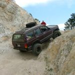
We came to the rockiest section and everyone spun their tires just a little. Dave caught a bad line and had to work on it a bit to get through, but no one needed any assistance.

More and more of the Montezuma Basin trail was visible the higher we got. It looks like a great trail. We also saw some extremely tight switchbacks on another mountain but we have no idea what trail that is.

It got colder and colder as we got closer to the top. There was no snow on the trail as we finally got to the pass. We all got out and took lots of pictures. The sun was finally setting and our timing was perfect. It made for some spectacular views.

We worked our way down the other side and the light left us for good soon after we started seeing trees around us. We stopped on the trail and everyone turned out their lights. We stood in the middle of the trail and looked at the stars, and it was beautiful.

When we got to the muddy section, the reflection of the moon on the watery parts made it look like the thick mud continued on for a long ways. Luckily there was only the first muddy part that sucked at our tires. We all made it through with very little effort.

The big stream crossing was a bit intimidating, because you couldn't see the bottom. It ended up being maybe a foot deep.

There were lots of people camping and it looked very inviting, but we were all hungry and we made our way back to Crested Butte in time for dinner at the last place still serving.

It was a long day but it was fantastic!

a_climb_to_the_pass
cheryl_at_the_top
cheryl_on_the_trail
climbing
close_to_the_top
colorful
cross_at_the_top
darkness_falling
dave_in_the_rockiest_section
dave_on_the_trail
down_from_the_pass
early_trail
everyone_climbing
filled-in_cave
foot_bridge
grave_marker
in_the_rocks
ladd_at_the_top
ladd_cleaning
ladd_on_the_trail
lakes
landscape
micheal_in_rocks
micheal_on_the_trail
monica_at_the_top
monica_on_the_trail
montezuma_basin_trail
narrow_trail
old_cabin
parked
pass_in_the_distance
pavement_to_the_trail
pearl_pass_sign
permanent_snow
rockiest_section
see_for_miles
sign_at_the_pass
snow_near_the_trail
start_of_rocky_section
sunset_reflected
sunset
trail_in_shadows
tundra
unknown_trail
up_to_the_pass
view_from_the_pass_part_1
view_from_the_pass_part_2
view_from_the_pass_part_3
view_from_the_pass_part_4
view_from_the_pass_part_5
view_from_the_pass_part_6
water_and_rocks
water_crossing
water_near_the_trail
watery_section

Reports from Other Days: 2

Use the arrows or dots to flip through the previews of the other reports for Pearl Pass. Click one of them to read more and see all of the photos from that day.

July 25, 2009

Led by Mike S.
We came down Annie Basin and Castle Creek Road, and we started on the north end of Pearl Pass with sun shining in a clear sky. Due to a lot of spring and early summer runoff the creek was running a bit high, so the first water crossing was a…
«
  • 1
  • 2
Join Us!
If you aren’t a Member or Subscriber, you can’t see all of the content on this site. Get membership information to see why this site is best when you join and log in

Information for Subscribers

When you log in you’ll see more information here:

  • Recent Community Forum posts
  • Recent polls
  • Upcoming Events you can attend
  • Links to online users

© 2000-2023 · TrailDamage.com · Terms and Conditions · About · Contact
Trail information is only accurate on the date posted. Trails may have changed or closed since that date. Use this information for historical purposes only.
Contact the Forest Service or Bureau of Land Management for up-to-date trail information.

/* ----------------------------------------- */ /* View slug: reports-other-reports-for-same-trail-slider - start */ /* ----------------------------------------- */ /* place the prev/next controls on the sides */ .td-transition-controls .wpv-filter-next-link, .td-transition-controls .wpv-filter-previous-link { border: none; font-size: 300%; position: absolute; top: 70px; } .td-transition-controls .wpv-filter-previous-link { left: 0; } .td-transition-controls .wpv-filter-next-link { right: 0; } /* center the page selector horizonatally */ .td-transition-controls ul.wpv_pagination_dots { text-align: center; margin-top: 10px; } /* center the page selector horizonatally */ .td-transition-controls ul.wpv_pagination_dots li.wpv_pagination_dots_item, .td-transition-controls .wpv_pagination_dots li a { display: inline-block; float: none; } /* remove the default styles */ .td-transition-controls .wpv_pagination_dots li a { text-decoration: none; border-bottom: none; } .td-slider-container { padding: 0 25px; margin-bottom: 20px; position: relative; width:100%; display:table; } .td-slides { position: relative; } .td-slides-image { float:left; display:table-cell; } .td-slides-image img { border:1px solid #c0c0c0; } .td-slides-content { padding:4px 4px 4px 10px; border-top:1px solid #c0c0c0; border-right:1px solid #c0c0c0; border-bottom:1px solid #c0c0c0; display:table-cell; height:227px; overflow:hidden; } .td-slides-content h3 { margin-top:8px; } .td-slides-leader { font-size:smaller; margin-top:4px; } /* ----------------------------------------- */ /* View slug: reports-other-reports-for-same-trail-slider - end */ /* ----------------------------------------- */
/* ----------------------------------------- */ /* Content Template: Template for a Single Report - start */ /* ----------------------------------------- */ .entry-header { display:none; } .entry-content h1 { margin-top:16px; padding-top:0; } h1 a { color:#222; } h1 a:hover { color:#666; } p.entry-meta { font-size:small; } #report-body-spacer { clear:both; width:100%; height:20px; } #addtoany-bar { margin-bottom:2em; text-align:center; } .category-reports .post-info .author, .post-info .date { display: none; } .addthis_recommended_horizontal { text-align:center !important; } /* ----------------------------------------- */ /* Content Template: Template for a Single Report - end */ /* ----------------------------------------- */ /* ----------------------------------------- */ /* Content Template: Loop item in REPORTS Runners - start */ /* ----------------------------------------- */ #runners-container { width:100%; clear:both; } .runner { border:1px solid #c0c0c0; margin:0 6px 6px 0; float:left; width:49%; height:81px; } .runner-image { float: left; } .runner-image img { margin:2px 10px 0 2px; height:75px; width:75px; } .runner-name { text-transform:uppercase; } .runner-name a { color:#222; } .runner-name a:hover { color:#666; } .runner-vehicle { font-size:small; } @media only screen and (max-width: 768px) { .runner { width:100%; } } /* ----------------------------------------- */ /* Content Template: Loop item in REPORTS Runners - end */ /* ----------------------------------------- */