TrailDamage.com

Photos, videos and information about 4x4 trails in Colorado and Utah

  • Trails
    • Colorado
    • Utah
  • Reports
    • Featured Photos
    • Featured Videos
    • Reports Calendar
  • Members
  • Search
  • Trail Damage Winners
  • FAQ
  • Community
  • Upcoming Events
  • Membership
  • Log In
  • Facebook
  • Instagram
  • RSS
  • Twitter
  • YouTube

Ophir Pass 080828

August 28, 2008 by Monica

Ophir Pass

Trail Run on August 28, 2008
Report and photos by Monica I., Trail Leader
View trail information for Ophir Pass

Michael M.
Black 2006 Jeep Wrangler Unlimited Rubicon
Monica I.
Red 2010 Jeep Wrangler Rubicon
Walt S.
Gray 2018 Jeep Wrangler Unlimited Rubicon

Walt had done Ophir Pass before, but it was new to the rest of us. We were just coming off of the Clear Lake trail, and the Ophir Pass trailhead was just a short drive up the pavement from there. The weather was still perfect, and we were looking forward to a mellow and scenic drive.

There were lots of people near the trailhead and Burro Bridge at the start, but we soon left them behind. We only saw a couple of other vehicles the rest of the time.

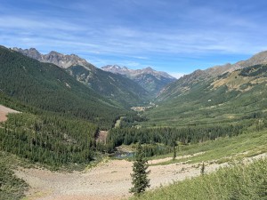
The scenery was good at the start, and Walt warned us that soon we'd have nowhere to pull off the trail for lunch. With that in mind, we stopped at a spur, parked, and had a good lunch. The scenery was really nice, staring at huge mountains in front of us.

We got moving again fairly quickly, though. It wasn't long before we were at the pass. As soon as we could see the other side we couldn't believe how gorgeous it was. It was very colorful, and very pretty.

We looked down the trail and couldn't see anyone coming up, so we headed down the long stretch of narrow trail. We immediately saw the old, illegal trail that used to bring people down from the pass not that long ago. It was very steep and it looked very loose and scary. No, thanks!

It was tough to keep our eyes on the road while we descended, but it was a pretty narrow trail with a big drop-off. We did our best to pay attention, and everyone made it through just fine.

We went into the trees, and the trail suddenly changed. It was shady, and everything was green. It was definitely a different feel.

We could see mines and remnants of tramways up on the Silver Mountain to the north, though there wasn't much left. It looked like it was rough mining.

The little town of Ophir was very cute, and we finally saw other vehicles. It was pretty crowded, actually. We slowly worked our way through town, and everyone noticed the Ophir post office. It is a little shack with barely enough room for a stool and work table. Cute!

When we got to the pavement, we turned north to go to Alta Lakes. Ophir Pass isn't just a handy way to get over to the other side -- it's absolutely gorgeous.

almost_to_the_pass
around_a_curve
blue_sky
colorful
curve
descent
early_bridge
green_near_ophir
lookout_peak
lots_of_trees
lunch
mineral_creek
narrow_trail
old_trail
ophir_part_1
ophir_part_2
ophir_pass_sign
over_the_pass
red-topped_mountain
san_miguel_county_line
see_for_miles
shady_spots
south_lookout_peak
start_of_the_trail
starting_down
talus
through_trees
trail_ahead
trailer_cutoff
trailhead_sign
uncompahgre_national_forest
valley_view
very_few_trees
water_crossing_1
water_crossing_2
yellow_mountain

Reports from Other Days: 3

Use the arrows or dots to flip through the previews of the other reports for Ophir Pass. Click one of them to read more and see all of the photos from that day.

September 5, 2020

Led by Matt K.
Ophir Pass was the last trail of the day for us, and it was still very nice and sunny. As we drove up Ophir Pass, we were passed by a lot of other people making their way down the Pass. We did stop for a short break before the shelf-road…
»
  • 1
  • 2
  • 3
Join Us!
If you aren’t a Member or Subscriber, you can’t see all of the content on this site. Get membership information to see why this site is best when you join and log in

Information for Subscribers

When you log in you’ll see more information here:

  • Recent Community Forum posts
  • Recent polls
  • Upcoming Events you can attend
  • Links to online users

© 2000-2021 · TrailDamage.com · Terms and Conditions · About · Contact
Trail information is only accurate on the date posted. Trails may have changed or closed since that date. Use this information for historical purposes only.
Contact the Forest Service or Bureau of Land Management for up-to-date trail information.

/* ----------------------------------------- */ /* View slug: reports-other-reports-for-same-trail-slider - start */ /* ----------------------------------------- */ /* place the prev/next controls on the sides */ .td-transition-controls .wpv-filter-next-link, .td-transition-controls .wpv-filter-previous-link { border: none; font-size: 300%; position: absolute; top: 70px; } .td-transition-controls .wpv-filter-previous-link { left: 0; } .td-transition-controls .wpv-filter-next-link { right: 0; } /* center the page selector horizonatally */ .td-transition-controls ul.wpv_pagination_dots { text-align: center; margin-top: 10px; } /* center the page selector horizonatally */ .td-transition-controls ul.wpv_pagination_dots li.wpv_pagination_dots_item, .td-transition-controls .wpv_pagination_dots li a { display: inline-block; float: none; } /* remove the default styles */ .td-transition-controls .wpv_pagination_dots li a { text-decoration: none; border-bottom: none; } .td-slider-container { padding: 0 25px; margin-bottom: 20px; position: relative; width:100%; display:table; } .td-slides { position: relative; } .td-slides-image { float:left; display:table-cell; } .td-slides-image img { border:1px solid #c0c0c0; } .td-slides-content { padding:4px 4px 4px 10px; border-top:1px solid #c0c0c0; border-right:1px solid #c0c0c0; border-bottom:1px solid #c0c0c0; display:table-cell; height:227px; overflow:hidden; } .td-slides-content h3 { margin-top:8px; } .td-slides-leader { font-size:smaller; margin-top:4px; } /* ----------------------------------------- */ /* View slug: reports-other-reports-for-same-trail-slider - end */ /* ----------------------------------------- */
/* ----------------------------------------- */ /* Content Template: Template for a Single Report - start */ /* ----------------------------------------- */ .entry-header { display:none; } .entry-content h1 { margin-top:16px; padding-top:0; } h1 a { color:#222; } h1 a:hover { color:#666; } p.entry-meta { font-size:small; } #report-body-spacer { clear:both; width:100%; height:20px; } #addtoany-bar { margin-bottom:2em; text-align:center; } .category-reports .post-info .author, .post-info .date { display: none; } .addthis_recommended_horizontal { text-align:center !important; } /* ----------------------------------------- */ /* Content Template: Template for a Single Report - end */ /* ----------------------------------------- */ /* ----------------------------------------- */ /* Content Template: Loop item in REPORTS Runners - start */ /* ----------------------------------------- */ #runners-container { width:100%; clear:both; } .runner { border:1px solid #c0c0c0; margin:0 6px 6px 0; float:left; width:49%; height:81px; } .runner-image { float: left; } .runner-image img { margin:2px 10px 0 2px; height:75px; width:75px; } .runner-name { text-transform:uppercase; } .runner-name a { color:#222; } .runner-name a:hover { color:#666; } .runner-vehicle { font-size:small; } @media only screen and (max-width: 768px) { .runner { width:100%; } } /* ----------------------------------------- */ /* Content Template: Loop item in REPORTS Runners - end */ /* ----------------------------------------- */