TrailDamage.com

Photos, videos and information about 4x4 trails in Colorado and Utah

  • Trails
    • Colorado
    • Utah
  • Reports
    • Featured Photos
    • Featured Videos
    • Reports Calendar
  • Members
  • Search
  • Trail Damage Winners
  • FAQ
  • Community
  • Upcoming Events
  • Membership
  • Log In
  • Facebook
  • Instagram
  • RSS
  • Twitter
  • YouTube

North Creek Pass 111012

October 12, 2011 by Monica

North Creek Pass

Trail Run on October 12, 2011
Report and photos by Monica I., Trail Leader
View trail information for North Creek Pass

Monica I.
Red 2010 Jeep Wrangler Rubicon
Hoa Q.
Black 1995 Land Rover Range Rover
Mike S.
Silver 2004 Jeep Wrangler Rubicon

There was snow on Abajo Peak and we weren't sure what to expect from the trail. We were taking it from the south end to the north end so we wouldn't find out for a little while. It was about 65 degrees at the trailhead so we had our hopes up.

The first parts of the trail were gorgeous, surrounded by thick and healthy aspen trees. Most of them had hundreds of yellow leaves though some were still green. It was definitely scenic.

We didn't stop very much until we got to the big switchback. There we parked and wandered around, enjoying the views. There is a big hill of talus that you can climb that really gives you some great angles on the scenery.

Even though we had gone many miles already it didn't seem to take long at all to get to the spur to Jackson Ridge. We took it, hoping to find something more challenging. We definitely found it when we found snow on the trail.

It was wet snow at first but then it turned to slick snow that packed down tightly. There were ruts in the road and one side dropped off quite a bit. We were sliding around a lot and then Monica had her fill of the danger. We turned around but then found on the map that we were almost at the end of the spur anyway.

When we got almost back to where the spur started we climbed up to the top of the ridge. What luck! The views were incredible. But the best part was that we were standing on top of a ridge filled with the stripes we'd been seeing on the sides of some of the mountains. Mike guessed that it was some old reclamation after mining operations. It was very overgrown but it would be a very long time before the stripes were no longer visible. We stayed there for a while just talking about it.

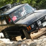
But we did get back to the trail eventually. The snow turned to a black mud that got all over Mike and our vehicles. It was nasty as we climbed.

We stopped at the pass for picture taking so Hoa could get us all in the snow. The sun was starting to go down and the trail was covered in a little to a lot of snow all the way down the other side. We took it slow but it wasn't long before the snow stopped being a danger. We were soon out and on the pavement.

The Blanding and Monticello areas have lots of deer because they don't hand out many hunting passes. We drove by at least a hundred of them on the way to town. It was crazy.

We got to Monticello and aired up in the parking lot of the pizza place as the sun went down. Then we went in and had a good dinner. It was the perfect end to a great first day.

abajo_peak
aspen_flat_sign
aspen_layers
aspens_part_1
aspens_part_2
aspens_part_3
aspens_part_4
aspens_part_5
aspens_part_6
basin
camp_jackson_sign
climbing
colors
dark_mud
dirt_trail
downhill_in_snow
green_and_yellow
group_shot
hiking_signs
hoa_on_the_trail_part_1
hoa_on_the_trail_part_2
hoa_taking_pictures
hoa_to_monticello
jackson_ridge
mellow
mike_and_hoa
mike_on_the_trail
monica_on_the_trail
near_the_pass
parked_at_the_tight_switchback
road_closure_sign
robertsons_pasture_sign
see_for_miles
seeing_snow
shades_of_green
shady_corner
sign_at_the_north_end
signs_at_the_south_end
skyline_trail_sign
snow_at_the_top
snow-capped
south_end_marker_1
south_end_marker_2
valley_view
view_from_jackson_ridge
watershed_sign
waves
winter_aspens
Join Us!
If you aren’t a Member or Subscriber, you can’t see all of the content on this site. Get membership information to see why this site is best when you join and log in

Information for Subscribers

When you log in you’ll see more information here:

  • Recent Community Forum posts
  • Recent polls
  • Upcoming Events you can attend
  • Links to online users

© 2000-2021 · TrailDamage.com · Terms and Conditions · About · Contact
Trail information is only accurate on the date posted. Trails may have changed or closed since that date. Use this information for historical purposes only.
Contact the Forest Service or Bureau of Land Management for up-to-date trail information.

/* ----------------------------------------- */ /* View slug: reports-other-reports-for-same-trail-slider - start */ /* ----------------------------------------- */ /* place the prev/next controls on the sides */ .td-transition-controls .wpv-filter-next-link, .td-transition-controls .wpv-filter-previous-link { border: none; font-size: 300%; position: absolute; top: 70px; } .td-transition-controls .wpv-filter-previous-link { left: 0; } .td-transition-controls .wpv-filter-next-link { right: 0; } /* center the page selector horizonatally */ .td-transition-controls ul.wpv_pagination_dots { text-align: center; margin-top: 10px; } /* center the page selector horizonatally */ .td-transition-controls ul.wpv_pagination_dots li.wpv_pagination_dots_item, .td-transition-controls .wpv_pagination_dots li a { display: inline-block; float: none; } /* remove the default styles */ .td-transition-controls .wpv_pagination_dots li a { text-decoration: none; border-bottom: none; } .td-slider-container { padding: 0 25px; margin-bottom: 20px; position: relative; width:100%; display:table; } .td-slides { position: relative; } .td-slides-image { float:left; display:table-cell; } .td-slides-image img { border:1px solid #c0c0c0; } .td-slides-content { padding:4px 4px 4px 10px; border-top:1px solid #c0c0c0; border-right:1px solid #c0c0c0; border-bottom:1px solid #c0c0c0; display:table-cell; height:227px; overflow:hidden; } .td-slides-content h3 { margin-top:8px; } .td-slides-leader { font-size:smaller; margin-top:4px; } /* ----------------------------------------- */ /* View slug: reports-other-reports-for-same-trail-slider - end */ /* ----------------------------------------- */
/* ----------------------------------------- */ /* Content Template: Template for a Single Report - start */ /* ----------------------------------------- */ .entry-header { display:none; } .entry-content h1 { margin-top:16px; padding-top:0; } h1 a { color:#222; } h1 a:hover { color:#666; } p.entry-meta { font-size:small; } #report-body-spacer { clear:both; width:100%; height:20px; } #addtoany-bar { margin-bottom:2em; text-align:center; } .category-reports .post-info .author, .post-info .date { display: none; } .addthis_recommended_horizontal { text-align:center !important; } /* ----------------------------------------- */ /* Content Template: Template for a Single Report - end */ /* ----------------------------------------- */ /* ----------------------------------------- */ /* Content Template: Loop item in REPORTS Runners - start */ /* ----------------------------------------- */ #runners-container { width:100%; clear:both; } .runner { border:1px solid #c0c0c0; margin:0 6px 6px 0; float:left; width:49%; height:81px; } .runner-image { float: left; } .runner-image img { margin:2px 10px 0 2px; height:75px; width:75px; } .runner-name { text-transform:uppercase; } .runner-name a { color:#222; } .runner-name a:hover { color:#666; } .runner-vehicle { font-size:small; } @media only screen and (max-width: 768px) { .runner { width:100%; } } /* ----------------------------------------- */ /* Content Template: Loop item in REPORTS Runners - end */ /* ----------------------------------------- */