TrailDamage.com

Photos, videos and information about 4x4 trails in Colorado and Utah

  • Trails
    • Colorado
    • Utah
  • Reports
    • Featured Photos
    • Featured Videos
    • Reports Calendar
  • Members
  • Search
  • Trail Damage Winners
  • FAQ
  • Community
  • Upcoming Events
  • Membership
  • Log In
  • Facebook
  • Instagram
  • RSS
  • Twitter
  • YouTube

Mount Baldy 220529

May 29, 2022 by Matt Kuczborski

Mount Baldy

Trail Run on May 29, 2022
Report and photos by Matt K., Trail Leader
View trail information for Mount Baldy

Matt K.
White 2016 Jeep Wrangler Unlimited Rubicon
Walt S.
Gray 2022 Jeep Wrangler Unlimited Rubicon 392

We met up at the trailhead for Mount Baldy. It looked like it was going to be nice day with the sun out, but a bit on the colder side.

At the trailhead, there was no snow on the trail but that did not last too long. The higher in elevation we drove, the more snow we ran into.

Matt and Walt drove through the big water holes. They were not that deep at that time.

The snow did not give us any issues on the trail. There were tracks on the trail from other vehicles that had already driven through.

We did pass a few Jeeps driving down Mount Baldy before we got to the shelf road.

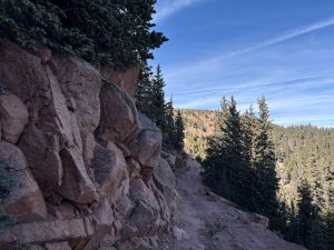
When we reached the shelf road, the only tracks on the road were from 4-wheelers. We continued making our way up the shelf road of Mount Baldy. In the sunny areas on the shelf road most of the snow had melted, but in the shady areas there was some snow on the trail.

When we got to the area where the hill on the shelf road was visible, we ran into a rockslide that blocked the trail. We thought only a 4-wheeler could make it past the big rocks without falling off the side of the trail.

There was just a little widening with a gentle slope on the uphill side right by the rockslide, so we decided to turn around instead of trying to drive backwards up the trail, which would have been pretty difficult and dangerous too since we were on the narrow shelf road. It did take us some time to turn both Jeeps around to go back. Matt, who had been in the lead, turned around first and managed without further issues after two tries. There was not much room for two Jeeps to pass each other, but Matt parked really close to the downhill side and Walt pulled passed him into the bit of gently sloped area on the uphill side, then Matt drove down the trail a bit and we were able to get Walt turned around as well.

When we were near the end of the shelf road on Mount Baldy, we ran into a few more Jeeps coming up to the shelf road. We told them about the rockslide. There was also no good spot for them to turn around where they were, so they drove in reverse for a little while until there was room enough to turn around in the treed area.

When we made it to the large open turn to go up Mount Baldy, we stopped for a late lunch. After lunch, we took the trail that went to the west for a way out. After we were out, we aired up and went home. We all had a great time on the trail, and we hoped the rockslide would be cleared soon.

IMG_1445
IMG_1446
IMG_1447
IMG_1448
IMG_1449
IMG_1450
IMG_1451
IMG_1452
IMG_1453
IMG_1454
IMG_1455
IMG_1456
IMG_1457
IMG_1458
IMG_1459
IMG_1460
IMG_1461
IMG_1462
IMG_1463
IMG_1464
IMG_1465
IMG_1466
IMG_1467
IMG_1468
IMG_1469
IMG_1470
IMG_1471
IMG_1472
IMG_1473
IMG_1474
IMG_1475
IMG_1476
IMG_1477
IMG_1478
IMG_8389
IMG_8391
IMG_8393
IMG_8394

Reports from Other Days: 7

Use the arrows or dots to flip through the previews of the other reports for Mount Baldy. Click one of them to read more and see all of the photos from that day.

May 15, 2021

Led by Matt K.
Mount Baldy was the only other trail for the day after we did Eagle Rock. It was still sunny out. Most of Mount Baldy was also dry and easy driving until we got above 10,000 feet because there was also snow on the trail at elevation. There were quite a…
»
  • 1
  • 2
  • 3
  • 4
  • 5
  • 6
  • 7
Join Us!
If you aren’t a Member or Subscriber, you can’t see all of the content on this site. Get membership information to see why this site is best when you join and log in

Information for Subscribers

When you log in you’ll see more information here:

  • Recent Community Forum posts
  • Recent polls
  • Upcoming Events you can attend
  • Links to online users

© 2000-2022 · TrailDamage.com · Terms and Conditions · About · Contact
Trail information is only accurate on the date posted. Trails may have changed or closed since that date. Use this information for historical purposes only.
Contact the Forest Service or Bureau of Land Management for up-to-date trail information.

/* ----------------------------------------- */ /* View slug: reports-other-reports-for-same-trail-slider - start */ /* ----------------------------------------- */ /* place the prev/next controls on the sides */ .td-transition-controls .wpv-filter-next-link, .td-transition-controls .wpv-filter-previous-link { border: none; font-size: 300%; position: absolute; top: 70px; } .td-transition-controls .wpv-filter-previous-link { left: 0; } .td-transition-controls .wpv-filter-next-link { right: 0; } /* center the page selector horizonatally */ .td-transition-controls ul.wpv_pagination_dots { text-align: center; margin-top: 10px; } /* center the page selector horizonatally */ .td-transition-controls ul.wpv_pagination_dots li.wpv_pagination_dots_item, .td-transition-controls .wpv_pagination_dots li a { display: inline-block; float: none; } /* remove the default styles */ .td-transition-controls .wpv_pagination_dots li a { text-decoration: none; border-bottom: none; } .td-slider-container { padding: 0 25px; margin-bottom: 20px; position: relative; width:100%; display:table; } .td-slides { position: relative; } .td-slides-image { float:left; display:table-cell; } .td-slides-image img { border:1px solid #c0c0c0; } .td-slides-content { padding:4px 4px 4px 10px; border-top:1px solid #c0c0c0; border-right:1px solid #c0c0c0; border-bottom:1px solid #c0c0c0; display:table-cell; height:227px; overflow:hidden; } .td-slides-content h3 { margin-top:8px; } .td-slides-leader { font-size:smaller; margin-top:4px; } /* ----------------------------------------- */ /* View slug: reports-other-reports-for-same-trail-slider - end */ /* ----------------------------------------- */
/* ----------------------------------------- */ /* Content Template: Template for a Single Report - start */ /* ----------------------------------------- */ .entry-header { display:none; } .entry-content h1 { margin-top:16px; padding-top:0; } h1 a { color:#222; } h1 a:hover { color:#666; } p.entry-meta { font-size:small; } #report-body-spacer { clear:both; width:100%; height:20px; } #addtoany-bar { margin-bottom:2em; text-align:center; } .category-reports .post-info .author, .post-info .date { display: none; } .addthis_recommended_horizontal { text-align:center !important; } /* ----------------------------------------- */ /* Content Template: Template for a Single Report - end */ /* ----------------------------------------- */ /* ----------------------------------------- */ /* Content Template: Loop item in REPORTS Runners - start */ /* ----------------------------------------- */ #runners-container { width:100%; clear:both; } .runner { border:1px solid #c0c0c0; margin:0 6px 6px 0; float:left; width:49%; height:81px; } .runner-image { float: left; } .runner-image img { margin:2px 10px 0 2px; height:75px; width:75px; } .runner-name { text-transform:uppercase; } .runner-name a { color:#222; } .runner-name a:hover { color:#666; } .runner-vehicle { font-size:small; } @media only screen and (max-width: 768px) { .runner { width:100%; } } /* ----------------------------------------- */ /* Content Template: Loop item in REPORTS Runners - end */ /* ----------------------------------------- */