TrailDamage.com

Photos, videos and information about 4x4 trails in Colorado and Utah

  • Trails
    • Colorado
    • Utah
  • Reports
    • Featured Photos
    • Featured Videos
    • Reports Calendar
  • Members
  • Search
  • Trail Damage Winners
  • FAQ
  • Community
  • Upcoming Events
  • Membership
  • Log In
  • Facebook
  • Instagram
  • RSS
  • Twitter
  • YouTube

Mosquito Pass 050903

September 3, 2005 by Mark Fleury

Mosquito Pass

Trail Run on September 3, 2005
Report and photos by Mark F., Trail Leader
View trail information for Mosquito Pass

Mark F.
Blue 2002 Jeep Wrangler
Gary R.
Yellow 1978 Jeep CJ-7

After we ran the Mount Bross trail and had lunch in Fairplay, we returned northward to route 12 going over Mosquito Pass. We took the turnoff up the valley to the South London Mine. About a mile up this valley we came to a three headed junction with the two side routes being chained and numerous signs between the center and right side route. Since one of the signs stated there was a locked gate ahead we decided to return to the main route to Mosquito Pass.

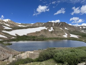
About a half mile above the North London Mine, a road comes up from the south (left) and is also marked locked gate ahead. We could not locate the gate from this high vantage point, but observed two lakes in this elevated valley which appeared to be partially ice rimed. We also observed three routes in various locations to the north and northeast, either going to lakes or partially up the sides of the mountains. We agreed these would be worth a future exploring trip.

From the North London Mine to the pass the road has numerous sections of rocks mixed with holes. Neither of us had to make a second attempt in any of these areas. There was still a large area of snow off to the side of the road near the top and we encountered a number of vehicles on the road and parked at the top.

At the pass we took the short spur to the south to get a better view of the area and avoid the crowd stopped at the pass. We were interested in taking the spur to the north but could not find anyone who knew its condition. Perhaps there is no way to turn around at the end and the return would be by backing up for two miles. We decided that would also be for another time.

The decent on the three or four switchbacks toward Leadville was uneventful. The west side is very mild compared to the east side.

Our descent on the switchbacks toward Leadville was uneventful. The west side is much easier.

We decided to try the Birdseye Gulch trail which begins near the base of the switchbacks. The first 1/5 mile had a smoother surface than the Mosquito Pass trail. It then becomes rocky with two sections (one level and one sloping) requiring a good line for a stock vehicle. There is a long, rutted, sloping section that could be interesting in wet weather. After a shallow, small stream crossing there is an extensive marshy area with deep, soft, black mud. Gary tried to cross this section in two locations and needed the help of a strap to return back to solid ground. We decided to return and attempt the remainder of the trail another time.

gary_and_mark
gary_on_birdseye_gulch_part_1
gary_on_birdseye_gulch_part_2
gary_on_birdseye_gulch_part_3
leadville
mark_and_gary_above_mosquito_pass
mark_and_gary
sign_for_father_dyer
sign_for_mosquito_pass
trail_on_the_east_side_of_the_pass
valley_to_the_northeast
valley_to_the_southeast

Reports from Other Days: 5

Use the arrows or dots to flip through the previews of the other reports for Mosquito Pass. Click one of them to read more and see all of the photos from that day.

August 15, 2020

Led by Matt K.
We met up at a gas station, and we waited for some time before finding out one of our group was not going to make it.  So we left to the start of Mosquito Pass.  We aired down in a small parking area right off the main highway. Soon after…
»
  • 1
  • 2
  • 3
  • 4
  • 5
Join Us!
If you aren’t a Member or Subscriber, you can’t see all of the content on this site. Get membership information to see why this site is best when you join and log in

Information for Subscribers

When you log in you’ll see more information here:

  • Recent Community Forum posts
  • Recent polls
  • Upcoming Events you can attend
  • Links to online users

© 2000-2023 · TrailDamage.com · Terms and Conditions · About · Contact
Trail information is only accurate on the date posted. Trails may have changed or closed since that date. Use this information for historical purposes only.
Contact the Forest Service or Bureau of Land Management for up-to-date trail information.

/* ----------------------------------------- */ /* View slug: reports-other-reports-for-same-trail-slider - start */ /* ----------------------------------------- */ /* place the prev/next controls on the sides */ .td-transition-controls .wpv-filter-next-link, .td-transition-controls .wpv-filter-previous-link { border: none; font-size: 300%; position: absolute; top: 70px; } .td-transition-controls .wpv-filter-previous-link { left: 0; } .td-transition-controls .wpv-filter-next-link { right: 0; } /* center the page selector horizonatally */ .td-transition-controls ul.wpv_pagination_dots { text-align: center; margin-top: 10px; } /* center the page selector horizonatally */ .td-transition-controls ul.wpv_pagination_dots li.wpv_pagination_dots_item, .td-transition-controls .wpv_pagination_dots li a { display: inline-block; float: none; } /* remove the default styles */ .td-transition-controls .wpv_pagination_dots li a { text-decoration: none; border-bottom: none; } .td-slider-container { padding: 0 25px; margin-bottom: 20px; position: relative; width:100%; display:table; } .td-slides { position: relative; } .td-slides-image { float:left; display:table-cell; } .td-slides-image img { border:1px solid #c0c0c0; } .td-slides-content { padding:4px 4px 4px 10px; border-top:1px solid #c0c0c0; border-right:1px solid #c0c0c0; border-bottom:1px solid #c0c0c0; display:table-cell; height:227px; overflow:hidden; } .td-slides-content h3 { margin-top:8px; } .td-slides-leader { font-size:smaller; margin-top:4px; } /* ----------------------------------------- */ /* View slug: reports-other-reports-for-same-trail-slider - end */ /* ----------------------------------------- */
/* ----------------------------------------- */ /* Content Template: Template for a Single Report - start */ /* ----------------------------------------- */ .entry-header { display:none; } .entry-content h1 { margin-top:16px; padding-top:0; } h1 a { color:#222; } h1 a:hover { color:#666; } p.entry-meta { font-size:small; } #report-body-spacer { clear:both; width:100%; height:20px; } #addtoany-bar { margin-bottom:2em; text-align:center; } .category-reports .post-info .author, .post-info .date { display: none; } .addthis_recommended_horizontal { text-align:center !important; } /* ----------------------------------------- */ /* Content Template: Template for a Single Report - end */ /* ----------------------------------------- */ /* ----------------------------------------- */ /* Content Template: Loop item in REPORTS Runners - start */ /* ----------------------------------------- */ #runners-container { width:100%; clear:both; } .runner { border:1px solid #c0c0c0; margin:0 6px 6px 0; float:left; width:49%; height:81px; } .runner-image { float: left; } .runner-image img { margin:2px 10px 0 2px; height:75px; width:75px; } .runner-name { text-transform:uppercase; } .runner-name a { color:#222; } .runner-name a:hover { color:#666; } .runner-vehicle { font-size:small; } @media only screen and (max-width: 768px) { .runner { width:100%; } } /* ----------------------------------------- */ /* Content Template: Loop item in REPORTS Runners - end */ /* ----------------------------------------- */