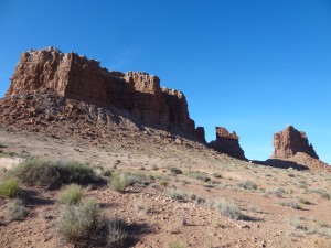
TrailDamage.com

Photos, videos and information about 4x4 trails in Colorado and Utah

  • Trails
    • Colorado
    • Utah
  • Reports
    • Featured Photos
    • Featured Videos
    • Reports Calendar
  • Members
  • Search
  • Trail Damage Winners
  • FAQ
  • Community
  • Upcoming Events
  • Membership
  • Log In
  • Facebook
  • Instagram
  • RSS
  • Twitter
  • YouTube

Molly’s Castle 130525

May 25, 2013 by Monica

Molly’s Castle

Trail Run on May 25, 2013
Report and photos by Monica I., Trail Leader
View trail information for Molly’s Castle

Jeffrey M.
Khaki 2006 Jeep Wrangler Unlimited Rubicon
Roger R.
White 2005 Jeep Wrangler Unlimited Rubicon
Monica I.
Red 2010 Jeep Wrangler Rubicon
Walt S.
Gray 2018 Jeep Wrangler Unlimited Rubicon
Bill S.
Khaki 2004 Jeep Wrangler Rubicon
Mike S.
Silver 2004 Jeep Wrangler Rubicon

None of us had been to Goblin Valley State Park and we were driving right by it, so we wanted to check it out on our way to Green River. There was a trail we could take between the highway and the park, so we aimed for it. Without the GPS waypoint we would have missed it. We turned off and headed toward Molly's Castle, the bluff we could see from the highway.

The beginning was a blast. It was a straight road covered in soft sand that was pretty deep in spots. We could see far ahead of us so we could actually go as fast as we wanted to go. It was a good time.

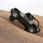
Once we got close to Molly's Castle we had to slow down because the trail abruptly changed from soft sand to patches of slickrock. There were even some ledges and bumps along the way, totally changing the trail. We weren't aired down, so it was especially bumpy.

The bluff itself was huge and pretty cool. We didn't see anyone climbing it, but we imagined it was popular with climbers.

Route finding was a bit weird in spots as the trail wasn't marked. It also didn't get used often as far as we could tell. We ended up finding our way through.

After the slickrock portion it was back to dirt but it was washed out and eroded in spots so it wasn't a fast trail. We thought it might continue as a trail on the other side of the pavement at the trail's end, but that part was paved.

It was a fun little trail. We turned left to go into the park. It was a bit expensive for what you got, we thought. You paid to go just a couple of miles past the Visitor Center to a parking lot with picnic tables. There were lots of people there. The wind was very, very strong. Only Jeffrey and Cody walked down the stairs to explore the goblins.

There were lots of signs to read and we hung out, but it was windy enough to drive us away. We soon found ourselves back in our Jeeps and headed for Green River. Even though we didn't do any real wheeling we still had a great day of scenery. It was nice to get to Green River and a shower.

big_view
bumps
cody_in_goblins
cody_taking_pictures
desert_views
formerly_muddy
goblin_1
goblin_2
goblin_3
goblin_4
goblin_5
goblin_6
goblin_7
goblin_8
goblin_valley_fees_2013
goblin_valley_part_1
goblin_valley_part_2
goblin_valley_part_3
goblin_valley_part_4
goblin_valley_part_5
goblin_valley_part_6
goblin_valley_part_7
goblin_valley_sign_1
goblin_valley_sign_2
goblin_valley_sign_3
goblin_valley_sign_4
goblin_valley_sign_5
goblin_valley_visitor_center
jeeps_at_goblin_valley
jeffrey_and_cody_part_1
jeffrey_and_cody_part_2
jeffrey_in_goblins
layers
ledges
mollys_castle_part_1
mollys_castle_part_2
mollys_castle_part_3
mollys_castle_part_4
next_to_mollys_castle
on_the_trail
red_and_white
sandy
see_for_miles
sign_near_goblin_valley
slickrock_section
start_of_the_trail
trail_ahead
walt_at_goblin_valley

Reports from Other Days: 2

Use the arrows or dots to flip through the previews of the other reports for Molly’s Castle. Click one of them to read more and see all of the photos from that day.

May 13, 2016

Led by Monica I.
We had been planning our Hanksville trip for a few years, and we were excited because it was finally here. We planned on doing a lot of trails in the Maze District of Canyonlands National Park, at least one trail in Capitol Reef National Park, and a slot canyon near…
»
  • 1
  • 2
Join Us!
If you aren’t a Member or Subscriber, you can’t see all of the content on this site. Get membership information to see why this site is best when you join and log in

Information for Subscribers

When you log in you’ll see more information here:

  • Recent Community Forum posts
  • Recent polls
  • Upcoming Events you can attend
  • Links to online users

© 2000-2021 · TrailDamage.com · Terms and Conditions · About · Contact
Trail information is only accurate on the date posted. Trails may have changed or closed since that date. Use this information for historical purposes only.
Contact the Forest Service or Bureau of Land Management for up-to-date trail information.

/* ----------------------------------------- */ /* View slug: reports-other-reports-for-same-trail-slider - start */ /* ----------------------------------------- */ /* place the prev/next controls on the sides */ .td-transition-controls .wpv-filter-next-link, .td-transition-controls .wpv-filter-previous-link { border: none; font-size: 300%; position: absolute; top: 70px; } .td-transition-controls .wpv-filter-previous-link { left: 0; } .td-transition-controls .wpv-filter-next-link { right: 0; } /* center the page selector horizonatally */ .td-transition-controls ul.wpv_pagination_dots { text-align: center; margin-top: 10px; } /* center the page selector horizonatally */ .td-transition-controls ul.wpv_pagination_dots li.wpv_pagination_dots_item, .td-transition-controls .wpv_pagination_dots li a { display: inline-block; float: none; } /* remove the default styles */ .td-transition-controls .wpv_pagination_dots li a { text-decoration: none; border-bottom: none; } .td-slider-container { padding: 0 25px; margin-bottom: 20px; position: relative; width:100%; display:table; } .td-slides { position: relative; } .td-slides-image { float:left; display:table-cell; } .td-slides-image img { border:1px solid #c0c0c0; } .td-slides-content { padding:4px 4px 4px 10px; border-top:1px solid #c0c0c0; border-right:1px solid #c0c0c0; border-bottom:1px solid #c0c0c0; display:table-cell; height:227px; overflow:hidden; } .td-slides-content h3 { margin-top:8px; } .td-slides-leader { font-size:smaller; margin-top:4px; } /* ----------------------------------------- */ /* View slug: reports-other-reports-for-same-trail-slider - end */ /* ----------------------------------------- */
/* ----------------------------------------- */ /* Content Template: Template for a Single Report - start */ /* ----------------------------------------- */ .entry-header { display:none; } .entry-content h1 { margin-top:16px; padding-top:0; } h1 a { color:#222; } h1 a:hover { color:#666; } p.entry-meta { font-size:small; } #report-body-spacer { clear:both; width:100%; height:20px; } #addtoany-bar { margin-bottom:2em; text-align:center; } .category-reports .post-info .author, .post-info .date { display: none; } .addthis_recommended_horizontal { text-align:center !important; } /* ----------------------------------------- */ /* Content Template: Template for a Single Report - end */ /* ----------------------------------------- */ /* ----------------------------------------- */ /* Content Template: Loop item in REPORTS Runners - start */ /* ----------------------------------------- */ #runners-container { width:100%; clear:both; } .runner { border:1px solid #c0c0c0; margin:0 6px 6px 0; float:left; width:49%; height:81px; } .runner-image { float: left; } .runner-image img { margin:2px 10px 0 2px; height:75px; width:75px; } .runner-name { text-transform:uppercase; } .runner-name a { color:#222; } .runner-name a:hover { color:#666; } .runner-vehicle { font-size:small; } @media only screen and (max-width: 768px) { .runner { width:100%; } } /* ----------------------------------------- */ /* Content Template: Loop item in REPORTS Runners - end */ /* ----------------------------------------- */