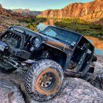
TrailDamage.com

Photos, videos and information about 4x4 trails in Colorado and Utah

  • Trails
    • Colorado
    • Utah
  • Reports
    • Featured Photos
    • Featured Videos
    • Reports Calendar
  • Members
  • Search
  • Trail Damage Winners
  • FAQ
  • Community
  • Upcoming Events
  • Membership
  • Log In
  • Facebook
  • Instagram
  • RSS
  • Twitter
  • YouTube

Moab Rim 191020

October 20, 2019 by Matt Kuczborski

Moab Rim

Trail Run on October 20, 2019
Report and photos by Matt K., Trail Leader
View trail information for Moab Rim

Matt K.
White 2016 Jeep Wrangler Unlimited Rubicon
Niko K.
Gray 2017 Jeep Wrangler Unlimited

We aired down in the parking area by the start of Moab Rim trail. The parking lot was mostly empty. After airing down, we started going up Moab Rim. It did not take long to get to the first obstacle which is called Devil's Crack. We both had to try a few times to get up and over the obstacle. We did get a lot of pictures with wheels off the ground in the Devil's Crack.

After that, the trail leading up to the Z-Turn was slow going but not very hard at all. It was off-camber in many spots, so we just had to pick the line we thought would be the best.

At the Z-Turn we both stopped and walked the obstacle. We both chose the same line to get up Z-Turn, but for the very top of Z-Turn where Matt went more to the left then Niko. Niko picked up a person who then took pictures for us. He rode with Niko on the rest of Moab Rim.

After the Z-Turn we had to make our way up to a steep incline with lots of small steps. On the way up, we both had no problems with the small steps.

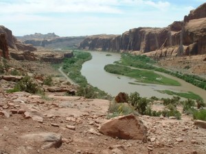
We stopped at an overlook stop for a short break, then continued to the "Y" in the road.

At the "Y" we went to the left and went to the Dome. Matt and Niko both went over the top of the Dome through the tire test stop near the very top. It was a steep and fun climb to the top.

On the way to the end of Moab Rim and the second overlook we both went down Sand Hill. It was fun going down Sand Hill but I don’t think a Jeep would be able to go up the hill, because the sand was very deep. After Sand Hill we went to the overlook. It looks out over the Moab Valley, and with the trees starting to turn yellow it was beautiful to look at.

After the overlook we returned the way we came back to the start of Moab Rim. For most of Moab Rim trail, we had no issues except for the one spot where Matt almost rolled his Jeep. It was the area that had the small steps and was very steep. Matt tried a different line going down one of the steps and almost went over the side of the cliff, but luckily he did not.

Going down the Z-Turn was fun and we didn’t have any trouble with the obstacle.

At Devil's Crack, Matt and Niko had to try two times to get the right line to make it down the Crack. Back at the parking area, we stopped for lunch and a break. It's an awesome trail!

IMG_5107
IMG_5108
IMG_5109
IMG_5110
IMG_5111
IMG_5112
IMG_5113
IMG_5114
IMG_5115
IMG_5116
IMG_5117
IMG_5118
IMG_5119
IMG_5120
IMG_5121
IMG_5122
IMG_5123
IMG_5124
IMG_5125
IMG_5126
IMG_5127
IMG_5128
IMG_5130
IMG_5132
IMG_5133
IMG_5135
IMG_5136
IMG_5137
IMG_5138
IMG_5139
IMG_5140
IMG_5141
IMG_5142
IMG_5143
IMG_5145
IMG_5146
IMG_5147
IMG_5148
IMG_5149
IMG_5150
IMG_5151
IMG_5152
IMG_5153
IMG_5154
IMG_5155
IMG_5156
IMG_5157
IMG_5158
IMG_5159
IMG_5161
IMG_5162
IMG_5163
IMG_5164
IMG_5165
IMG_5166
IMG_5167
IMG_5168
IMG_5169
IMG_5170
IMG_5171
IMG_5172
IMG_5173
IMG_5174
IMG_5175
IMG_5176
IMG_5177
IMG_5178
IMG_5179
IMG_5180
IMG_5181
IMG_5182

Reports from Other Days: 4

Use the arrows or dots to flip through the previews of the other reports for Moab Rim. Click one of them to read more and see all of the photos from that day.

May 16, 2004

Led by Monica I.
We had walked a bit of this trail last year and decided it was too much for us with the group we had then. This year we were up for it so we took it on. Though it was scary in places it was a great trail and had a…
«
  • 1
  • 2
  • 3
  • 4
Join Us!
If you aren’t a Member or Subscriber, you can’t see all of the content on this site. Get membership information to see why this site is best when you join and log in

Information for Subscribers

When you log in you’ll see more information here:

  • Recent Community Forum posts
  • Recent polls
  • Upcoming Events you can attend
  • Links to online users

© 2000-2022 · TrailDamage.com · Terms and Conditions · About · Contact
Trail information is only accurate on the date posted. Trails may have changed or closed since that date. Use this information for historical purposes only.
Contact the Forest Service or Bureau of Land Management for up-to-date trail information.

/* ----------------------------------------- */ /* View slug: reports-other-reports-for-same-trail-slider - start */ /* ----------------------------------------- */ /* place the prev/next controls on the sides */ .td-transition-controls .wpv-filter-next-link, .td-transition-controls .wpv-filter-previous-link { border: none; font-size: 300%; position: absolute; top: 70px; } .td-transition-controls .wpv-filter-previous-link { left: 0; } .td-transition-controls .wpv-filter-next-link { right: 0; } /* center the page selector horizonatally */ .td-transition-controls ul.wpv_pagination_dots { text-align: center; margin-top: 10px; } /* center the page selector horizonatally */ .td-transition-controls ul.wpv_pagination_dots li.wpv_pagination_dots_item, .td-transition-controls .wpv_pagination_dots li a { display: inline-block; float: none; } /* remove the default styles */ .td-transition-controls .wpv_pagination_dots li a { text-decoration: none; border-bottom: none; } .td-slider-container { padding: 0 25px; margin-bottom: 20px; position: relative; width:100%; display:table; } .td-slides { position: relative; } .td-slides-image { float:left; display:table-cell; } .td-slides-image img { border:1px solid #c0c0c0; } .td-slides-content { padding:4px 4px 4px 10px; border-top:1px solid #c0c0c0; border-right:1px solid #c0c0c0; border-bottom:1px solid #c0c0c0; display:table-cell; height:227px; overflow:hidden; } .td-slides-content h3 { margin-top:8px; } .td-slides-leader { font-size:smaller; margin-top:4px; } /* ----------------------------------------- */ /* View slug: reports-other-reports-for-same-trail-slider - end */ /* ----------------------------------------- */
/* ----------------------------------------- */ /* Content Template: Template for a Single Report - start */ /* ----------------------------------------- */ .entry-header { display:none; } .entry-content h1 { margin-top:16px; padding-top:0; } h1 a { color:#222; } h1 a:hover { color:#666; } p.entry-meta { font-size:small; } #report-body-spacer { clear:both; width:100%; height:20px; } #addtoany-bar { margin-bottom:2em; text-align:center; } .category-reports .post-info .author, .post-info .date { display: none; } .addthis_recommended_horizontal { text-align:center !important; } /* ----------------------------------------- */ /* Content Template: Template for a Single Report - end */ /* ----------------------------------------- */ /* ----------------------------------------- */ /* Content Template: Loop item in REPORTS Runners - start */ /* ----------------------------------------- */ #runners-container { width:100%; clear:both; } .runner { border:1px solid #c0c0c0; margin:0 6px 6px 0; float:left; width:49%; height:81px; } .runner-image { float: left; } .runner-image img { margin:2px 10px 0 2px; height:75px; width:75px; } .runner-name { text-transform:uppercase; } .runner-name a { color:#222; } .runner-name a:hover { color:#666; } .runner-vehicle { font-size:small; } @media only screen and (max-width: 768px) { .runner { width:100%; } } /* ----------------------------------------- */ /* Content Template: Loop item in REPORTS Runners - end */ /* ----------------------------------------- */