TrailDamage.com

Photos, videos and information about 4x4 trails in Colorado and Utah

  • Trails
    • Colorado
    • Utah
  • Reports
    • Featured Photos
    • Featured Videos
    • Reports Calendar
  • Members
  • Search
  • Trail Damage Winners
  • FAQ
  • Community
  • Upcoming Events
  • Membership
  • Log In
  • Facebook
  • Instagram
  • RSS
  • Twitter
  • YouTube

Medano Pass 050807

August 7, 2005 by Monica

Medano Pass

Trail Run on August 7, 2005
Report and photos by Monica I., Trail Leader
View trail information for Medano Pass

Bob S.
Green 1997 Jeep Wrangler
Bob R.
Green 2003 Jeep Wrangler Rubicon
Monica I.
Red 2010 Jeep Wrangler Rubicon
Ladd G.
Green 2003 Jeep Wrangler Rubicon

The Great Sand Dunes are one of the coolest things to see in Colorado. While driving to the trailhead you can see a grassy plain, huge sand dunes, and rocky Sangre de Cristo mountains all at the same time. We stopped at the Visitor's Center to walk out on the sand for a bit while Bob R. buried himself up to his ankles in the wet sand. We took our tourist pictures and got back in the Jeeps to do the trail.

It starts off as a sandy road and soon we got to a parking area where everyone decided to air down and disconnect sway bars. Then we continued on the smooth sand, around corners and over small hills. We got very close to the sand dunes and watched people climb up and down them.

We were passing some hikers when they asked us for a ride. We packed them and their packs into the Jeeps and drove them a little way to where they were meeting some people.

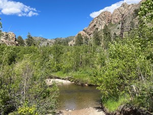
Unfortunately the sandy trail soon turns to a rocky dirt trail as you leave the proximity of the dunes and start to head up to the pass in the mountains. While you're there you cross Medano Creek multiple times. The creek was never very deep and we had fun splashing through it.

We started to climb to the top, passing some awesome camp sites and a few other vehicles on the way. No one was camping, which was surprising. The sites are all far from each other and some are large enough for a group of our usual size, so we might camp the next time we are out in that area.

When we got to the pass there were a few people on horses. The pass is marked with the sign at the border of the Great Sand Dunes park. It's still in the trees.

We drove a little way down the other side looking for a better view but the trees are pretty thick. We stopped at a wide, flat area for lunch in the sun and talked more about our trip to Blanca Peak the day before.

The trail on the way out is mellow and we all enjoyed the quiet as we drove out to the highway. We aired up and Bob S. and Monica headed off to do Hermit Pass while Ladd and Bob R. headed for home. It was a nice, relaxing trip.

beware_of_bears
bob_r_in_sand
bob_r_splash_part_1
bob_r_splash_part_2
bob_r_splash_part_3
bob_r_splash_part_4
bob_r_walking
bob_s_and_monica
bob_s_splash_part_1
bob_s_splash_part_2
bob_s_splash_part_3
bob_s_splash_part_4
bob_s_splash_part_5
bob_s_splash_part_6
bob_s_splash_part_7
bob_s_splash_part_8
bob_s_splash_part_9
bob_s_tourist
cabin
colorful
contrast
creager_reservoir_part_1
creager_reservoir_part_2
dunes_in_the_distance
dunes
flat_trail
green_jeeps
grooves_in_sand
ladd_in_the_sand
ladd_splash_part_1
ladd_splash_part_2
ladd_splash_part_3
ladd_splash_part_4
ladd_splash_part_5
ladd_splash_part_6
little_people
lunch
meadow
monica_posing
monica_splash_part_1
monica_splash_part_2
monica_splash_part_3
mountains
rocky_trail
sand_and_sky
sandy_trail
sign_on_the_trail
sign_to_hiking_trail
to_the_end
trees_in_the_sand
walking_towards_the_dunes
water_crossing_1_part_1
water_crossing_1_part_2
water_crossing_2
water_crossing_3
water_crossing_4
water_crossing_5_part_1
water_crossing_5_part_2
wet_sand

Reports from Other Days: 3

Use the arrows or dots to flip through the previews of the other reports for Medano Pass. Click one of them to read more and see all of the photos from that day.

August 26, 2007

Led by Matt K.
It was a beautiful, warm and sunny day. We had just come down from camping at Lake Como on the Blanca Peak trail, so our day had really started out well. We headed up Highway 150, topped off our fuel tanks, and then proceeded on to pay our way at…
»
  • 1
  • 2
  • 3
Join Us!
If you aren’t a Member or Subscriber, you can’t see all of the content on this site. Get membership information to see why this site is best when you join and log in

Information for Subscribers

When you log in you’ll see more information here:

  • Recent Community Forum posts
  • Recent polls
  • Upcoming Events you can attend
  • Links to online users

© 2000-2022 · TrailDamage.com · Terms and Conditions · About · Contact
Trail information is only accurate on the date posted. Trails may have changed or closed since that date. Use this information for historical purposes only.
Contact the Forest Service or Bureau of Land Management for up-to-date trail information.

/* ----------------------------------------- */ /* View slug: reports-other-reports-for-same-trail-slider - start */ /* ----------------------------------------- */ /* place the prev/next controls on the sides */ .td-transition-controls .wpv-filter-next-link, .td-transition-controls .wpv-filter-previous-link { border: none; font-size: 300%; position: absolute; top: 70px; } .td-transition-controls .wpv-filter-previous-link { left: 0; } .td-transition-controls .wpv-filter-next-link { right: 0; } /* center the page selector horizonatally */ .td-transition-controls ul.wpv_pagination_dots { text-align: center; margin-top: 10px; } /* center the page selector horizonatally */ .td-transition-controls ul.wpv_pagination_dots li.wpv_pagination_dots_item, .td-transition-controls .wpv_pagination_dots li a { display: inline-block; float: none; } /* remove the default styles */ .td-transition-controls .wpv_pagination_dots li a { text-decoration: none; border-bottom: none; } .td-slider-container { padding: 0 25px; margin-bottom: 20px; position: relative; width:100%; display:table; } .td-slides { position: relative; } .td-slides-image { float:left; display:table-cell; } .td-slides-image img { border:1px solid #c0c0c0; } .td-slides-content { padding:4px 4px 4px 10px; border-top:1px solid #c0c0c0; border-right:1px solid #c0c0c0; border-bottom:1px solid #c0c0c0; display:table-cell; height:227px; overflow:hidden; } .td-slides-content h3 { margin-top:8px; } .td-slides-leader { font-size:smaller; margin-top:4px; } /* ----------------------------------------- */ /* View slug: reports-other-reports-for-same-trail-slider - end */ /* ----------------------------------------- */
/* ----------------------------------------- */ /* Content Template: Template for a Single Report - start */ /* ----------------------------------------- */ .entry-header { display:none; } .entry-content h1 { margin-top:16px; padding-top:0; } h1 a { color:#222; } h1 a:hover { color:#666; } p.entry-meta { font-size:small; } #report-body-spacer { clear:both; width:100%; height:20px; } #addtoany-bar { margin-bottom:2em; text-align:center; } .category-reports .post-info .author, .post-info .date { display: none; } .addthis_recommended_horizontal { text-align:center !important; } /* ----------------------------------------- */ /* Content Template: Template for a Single Report - end */ /* ----------------------------------------- */ /* ----------------------------------------- */ /* Content Template: Loop item in REPORTS Runners - start */ /* ----------------------------------------- */ #runners-container { width:100%; clear:both; } .runner { border:1px solid #c0c0c0; margin:0 6px 6px 0; float:left; width:49%; height:81px; } .runner-image { float: left; } .runner-image img { margin:2px 10px 0 2px; height:75px; width:75px; } .runner-name { text-transform:uppercase; } .runner-name a { color:#222; } .runner-name a:hover { color:#666; } .runner-vehicle { font-size:small; } @media only screen and (max-width: 768px) { .runner { width:100%; } } /* ----------------------------------------- */ /* Content Template: Loop item in REPORTS Runners - end */ /* ----------------------------------------- */