TrailDamage.com

Photos, videos and information about 4x4 trails in Colorado and Utah

  • Trails
    • Colorado
    • Utah
  • Reports
    • Featured Photos
    • Featured Videos
    • Reports Calendar
  • Members
  • Search
  • Trail Damage Winners
  • FAQ
  • Community
  • Upcoming Events
  • Membership
  • Log In
  • Facebook
  • Instagram
  • RSS
  • Twitter
  • YouTube

McClellan Mountain 070908

September 8, 2007 by Monica

McClellan Mountain

Trail Run on September 8, 2007
Report and photos by Monica I., Trail Leader
View trail information for McClellan Mountain

Chad S.
Blue 2004 Jeep Wrangler
Don W.
Silver 2005 Jeep Wrangler Rubicon
Bob R.
Green 2003 Jeep Wrangler Rubicon
Mike S.
Silver 2004 Jeep Wrangler Rubicon
Mike C.
Red 2012 Jeep Wrangler Unlimited Rubicon
Mark F.
Blue 2002 Jeep Wrangler

We ran this trail in the opposite direction just after running Argentine Pass. That meant we started at the Waldorf Mine and went up the big hill. It wasn't as fun running the rocks at the end in that direction, but it was still a fantastic time.

We all had a great time climbing the loose hill to start the trail, and we took the northern-most switchbacks first. We planned on going to the Santiago Mine on the way back down.

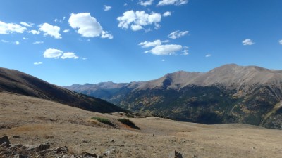
The way up to the top was very scenic and no one had any issues. It was chilly (and sometimes cold) but sunny, so we all worked on our tans on whatever skin was still exposed.

When we got to the top of the switchbacks we found an Explorer at the top. We parked all around it and chatted briefly with the owners. They were all smiles, and they headed back down before we did.

The top was a rush, looking down on the other side. If you accidentally kept going on the trail you wouldn't survive. It was really, really steep and very far to the bottom. We even saw a mangled car at the very bottom.

We saw many, many people on the hiking trail to Grays Peak and Torreys Peak. It was very crowded. The day was perfect for a hike, though.

We soon started down and caught up to the Explorer at the switchback with the spur just as a Cherokee was on its way up. We all met at that intersection and it was like it was choreographed as vehicles moved out of the way. We kept going on the spur as the other two cars passed each other on the switchback.

We went up to the overlook but it wasn't much to see, so thankfully it was short. Then we headed off to the unnamed mine.

The trail there was much different. It was narrow in most places and overgrown in some areas. Some of the rock had come down into the trail in some places, making it very tippy at times. One part was a little loose, too. The switchbacks were tight as we worked our way down.

We all explored the area around the unnamed mine for a bit, enjoying the lack of wind. It would have been a great place for lunch, so we'll have to remember that spot.

We soon headed back up to the main trail and then down to the Santiago Mine. When we got there, some of us went into the mine while others stayed chatting at the vehicles. The people in the Explorer were there, and it turned out that one of them was writing a book about that mine and others in the area. He was full of information about it, and we were lucky to have been there at the same time.

We spent a lot of time exploring the mine and the area, but then headed back down. The rocky section working its way down to the Argentine Pass trail was very narrow, with thick pine tree branches all over our Jeeps. The portion of the trail after crossing Argentine Pass was much better, and we had fun on the rocks.

When we got to one of the few escape trails that takes you back up to Argentine Pass we split up, with half of the group going out to head for home with the other half staying down to explore the rocky section.

While we were splitting up, Chad's tie rod simply fell off of his Jeep. He stopped, and we all got out. Miraculously, Don found the castle nut in about three seconds, and he had a cotter pin. Chad was back in business in no time.

The rest of the rocky trail was fun, and we all noticed the fantastic camp spots down in that area. We even saw a deer very close to the trail. Soon we were off the trail and we headed back to the Argentine Pass trailhead and turned to finish Guanella Pass. It was a great day in the high country.

around_a_bend
at_the_top
bob_in_the_santiago_mine
car_over_the_top
chad_above_timberline
chad_hood
chad_in_scenery
chad_on_the_trail
chad_trail_damage_part_1
chad_trail_damage_part_2
climbing
creek_crossing
creek_in_the_trail
deer
don_in_scenery
green
hiking_trail_to_torreys_peak_and_grays_peak
i-70
jeeps_on_the_trail
long_straight_trail
lots_of_trail
lower_part_of_the_trail
mark_on_the_trail
mellow_trail
mike_c_on_the_trail
mike_s_and_don_at_the_top
mike_s_on_the_trail
mountain_view
mountains_in_cloud_shadows
narrow_and_tippy
near_the_top
over_the_top
pendleton_mountain
puddle
rocky_downhill
santiago_mine_part_1
santiago_mine_part_2
santiago_mine_part_3
santiago_mine_part_4
santiago_mine_part_5
santiago_mine_part_6
santiago_mine_part_7
santiago_mine_part_8
santiago_mine_part_9
spur_to_the_overlook
switchback_to_the_unnamed_mine
switchbacks
thinning_trees
through_aspens
tippy_parking
torreys_peak_part_1
torreys_peak_part_2
trail_below
trail_into_the_sky
tundra_trail
under_power_lines
unnamed_mine_part_1
unnamed_mine_part_2
unnamed_mine_shack_part_1
unnamed_mine_shack_part_2
unnamed_mine_shack_part_3
up_to_a_switchback

Reports from Other Days: 4

Use the arrows or dots to flip through the previews of the other reports for McClellan Mountain. Click one of them to read more and see all of the photos from that day.

September 15, 2018

Led by Monica I.
We started our day with Argentine Pass, and we had lunch at the top.  The sky was clear and the weather was perfect.  We saw a lot of people on the trail but everyone was happy to be out, so it was nice to see everyone.  We started at the…
»
  • 1
  • 2
  • 3
  • 4
Join Us!
If you aren’t a Member or Subscriber, you can’t see all of the content on this site. Get membership information to see why this site is best when you join and log in

Information for Subscribers

When you log in you’ll see more information here:

  • Recent Community Forum posts
  • Recent polls
  • Upcoming Events you can attend
  • Links to online users

© 2000-2021 · TrailDamage.com · Terms and Conditions · About · Contact
Trail information is only accurate on the date posted. Trails may have changed or closed since that date. Use this information for historical purposes only.
Contact the Forest Service or Bureau of Land Management for up-to-date trail information.

/* ----------------------------------------- */ /* View slug: reports-other-reports-for-same-trail-slider - start */ /* ----------------------------------------- */ /* place the prev/next controls on the sides */ .td-transition-controls .wpv-filter-next-link, .td-transition-controls .wpv-filter-previous-link { border: none; font-size: 300%; position: absolute; top: 70px; } .td-transition-controls .wpv-filter-previous-link { left: 0; } .td-transition-controls .wpv-filter-next-link { right: 0; } /* center the page selector horizonatally */ .td-transition-controls ul.wpv_pagination_dots { text-align: center; margin-top: 10px; } /* center the page selector horizonatally */ .td-transition-controls ul.wpv_pagination_dots li.wpv_pagination_dots_item, .td-transition-controls .wpv_pagination_dots li a { display: inline-block; float: none; } /* remove the default styles */ .td-transition-controls .wpv_pagination_dots li a { text-decoration: none; border-bottom: none; } .td-slider-container { padding: 0 25px; margin-bottom: 20px; position: relative; width:100%; display:table; } .td-slides { position: relative; } .td-slides-image { float:left; display:table-cell; } .td-slides-image img { border:1px solid #c0c0c0; } .td-slides-content { padding:4px 4px 4px 10px; border-top:1px solid #c0c0c0; border-right:1px solid #c0c0c0; border-bottom:1px solid #c0c0c0; display:table-cell; height:227px; overflow:hidden; } .td-slides-content h3 { margin-top:8px; } .td-slides-leader { font-size:smaller; margin-top:4px; } /* ----------------------------------------- */ /* View slug: reports-other-reports-for-same-trail-slider - end */ /* ----------------------------------------- */
/* ----------------------------------------- */ /* Content Template: Template for a Single Report - start */ /* ----------------------------------------- */ .entry-header { display:none; } .entry-content h1 { margin-top:16px; padding-top:0; } h1 a { color:#222; } h1 a:hover { color:#666; } p.entry-meta { font-size:small; } #report-body-spacer { clear:both; width:100%; height:20px; } #addtoany-bar { margin-bottom:2em; text-align:center; } .category-reports .post-info .author, .post-info .date { display: none; } .addthis_recommended_horizontal { text-align:center !important; } /* ----------------------------------------- */ /* Content Template: Template for a Single Report - end */ /* ----------------------------------------- */ /* ----------------------------------------- */ /* Content Template: Loop item in REPORTS Runners - start */ /* ----------------------------------------- */ #runners-container { width:100%; clear:both; } .runner { border:1px solid #c0c0c0; margin:0 6px 6px 0; float:left; width:49%; height:81px; } .runner-image { float: left; } .runner-image img { margin:2px 10px 0 2px; height:75px; width:75px; } .runner-name { text-transform:uppercase; } .runner-name a { color:#222; } .runner-name a:hover { color:#666; } .runner-vehicle { font-size:small; } @media only screen and (max-width: 768px) { .runner { width:100%; } } /* ----------------------------------------- */ /* Content Template: Loop item in REPORTS Runners - end */ /* ----------------------------------------- */