TrailDamage.com

Photos, videos and information about 4x4 trails in Colorado and Utah

  • Trails
    • Colorado
    • Utah
  • Reports
    • Featured Photos
    • Featured Videos
    • Reports Calendar
  • Members
  • Search
  • Trail Damage Winners
  • FAQ
  • Community
  • Upcoming Events
  • Membership
  • Log In
  • Facebook
  • Instagram
  • RSS
  • Twitter
  • YouTube

Lead King Basin 050903

September 3, 2005 by Monica

Lead King Basin

Trail Run on September 3, 2005
Report and photos by Monica I., Trail Leader
View trail information for Lead King Basin

Dave E.
Blue 1999 Jeep Cherokee
Bob R.
Green 2003 Jeep Wrangler Rubicon
Micheal S.
Maroon 1988 Jeep Cherokee
Cheryl W.
Orange 2006 Jeep Wrangler Unlimited Rubicon
Ladd G.
Green 2003 Jeep Wrangler Rubicon
Monica I.
Red 2010 Jeep Wrangler Rubicon
Dave B.
Black 2004 Jeep Wrangler Rubicon
Walt S.
Gray 2022 Jeep Wrangler Unlimited Rubicon 392

This trail run was the start of our Labor Day weekend trip to trails in the Crested Butte area. We had hoped to do this along with Schofield Pass and Crystal City, but unfortunately there was still too much snow from last winter on Schofield Pass for us to tackle that one. It just meant we ended up with a longer evening spent in Crested Butte, which gave us lots of time to relax and enjoy our evening.

Our day was sunny and gorgeous, which was nice. It also made it very dusty, though.

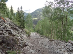
We took our time and worked our way up and over the hills, enjoying the scenery. We saw one Jeep that was giving people tours, and even found Randy out with friends and family on the trail (another member not with us for this trip).

We stopped for lunch at a small camping area and enjoyed the sunshine close to timberline. The weather couldn't have been any better!

When we got to the intersection for Crystal City and Schofield Pass we finally decided that we weren't going to go check out the snow on Schofield Pass. There didn't seem to be enough room to turn around -- at least not with as many vehicles as we had. Later, we found out that people were even having to winch ATVs through the snow. It sounded much too dangerous and risky so we were going to have to save Schofield Pass for another trip.

We turned right and headed down for Crystal City instead. Lead King Basin was just as beautiful as ever, and we really enjoyed our trip there.

airing_down
aspens
bob_on_the_trail
cheryl_in_dust
cheryl_on_the_trail
colorful
crystal_river_part_1
crystal_river_part_2
crystal_river_part_3
crystal_river_part_4
crystal_river_part_5
crystal_river_part_6
dave_and_stephanie
dave_and_walt
dave_b_on_the_trail
dave_e_at_lunch
dave_e_on_the_trail
dusty_trail
early_climb
easy_trail
falling_water
green_and_brown
intersection_near_marble
ladd_and_bob
ladd_and_dave_b
ladd_on_the_trail
ladd_parked
long_trail
mellow_section
menacing_mountains
michael_on_the_trail
mountain_range
mountains
mud
popular_mountain
river_rocks
rocky
sign_at_trailhead
sign
smooth_trail
start_of_the_trail
trail_across_the_valley
trail_on_the_edge
trail_with_a_view
view_at_lunch
walt_on_the_trail
water_crossing_1
water_crossing_2
waterfalls_part_1
waterfalls_part_2
watery
wild_flowers

Reports from Other Days: 2

Use the arrows or dots to flip through the previews of the other reports for Lead King Basin. Click one of them to read more and see all of the photos from that day.

August 10, 2012

Led by Monica I.
We remembered Lead King Basin as the tougher of the two trails when compared to Crystal City. We found out we were wrong, though. Yes, it’s steeper and possibly more dangerous, but it was dry, smooth, and easy for us. It actually ended up being the quicker trail. We came…
»
  • 1
  • 2
Join Us!
If you aren’t a Member or Subscriber, you can’t see all of the content on this site. Get membership information to see why this site is best when you join and log in

Information for Subscribers

When you log in you’ll see more information here:

  • Recent Community Forum posts
  • Recent polls
  • Upcoming Events you can attend
  • Links to online users

© 2000-2023 · TrailDamage.com · Terms and Conditions · About · Contact
Trail information is only accurate on the date posted. Trails may have changed or closed since that date. Use this information for historical purposes only.
Contact the Forest Service or Bureau of Land Management for up-to-date trail information.

/* ----------------------------------------- */ /* View slug: reports-other-reports-for-same-trail-slider - start */ /* ----------------------------------------- */ /* place the prev/next controls on the sides */ .td-transition-controls .wpv-filter-next-link, .td-transition-controls .wpv-filter-previous-link { border: none; font-size: 300%; position: absolute; top: 70px; } .td-transition-controls .wpv-filter-previous-link { left: 0; } .td-transition-controls .wpv-filter-next-link { right: 0; } /* center the page selector horizonatally */ .td-transition-controls ul.wpv_pagination_dots { text-align: center; margin-top: 10px; } /* center the page selector horizonatally */ .td-transition-controls ul.wpv_pagination_dots li.wpv_pagination_dots_item, .td-transition-controls .wpv_pagination_dots li a { display: inline-block; float: none; } /* remove the default styles */ .td-transition-controls .wpv_pagination_dots li a { text-decoration: none; border-bottom: none; } .td-slider-container { padding: 0 25px; margin-bottom: 20px; position: relative; width:100%; display:table; } .td-slides { position: relative; } .td-slides-image { float:left; display:table-cell; } .td-slides-image img { border:1px solid #c0c0c0; } .td-slides-content { padding:4px 4px 4px 10px; border-top:1px solid #c0c0c0; border-right:1px solid #c0c0c0; border-bottom:1px solid #c0c0c0; display:table-cell; height:227px; overflow:hidden; } .td-slides-content h3 { margin-top:8px; } .td-slides-leader { font-size:smaller; margin-top:4px; } /* ----------------------------------------- */ /* View slug: reports-other-reports-for-same-trail-slider - end */ /* ----------------------------------------- */
/* ----------------------------------------- */ /* Content Template: Template for a Single Report - start */ /* ----------------------------------------- */ .entry-header { display:none; } .entry-content h1 { margin-top:16px; padding-top:0; } h1 a { color:#222; } h1 a:hover { color:#666; } p.entry-meta { font-size:small; } #report-body-spacer { clear:both; width:100%; height:20px; } #addtoany-bar { margin-bottom:2em; text-align:center; } .category-reports .post-info .author, .post-info .date { display: none; } .addthis_recommended_horizontal { text-align:center !important; } /* ----------------------------------------- */ /* Content Template: Template for a Single Report - end */ /* ----------------------------------------- */ /* ----------------------------------------- */ /* Content Template: Loop item in REPORTS Runners - start */ /* ----------------------------------------- */ #runners-container { width:100%; clear:both; } .runner { border:1px solid #c0c0c0; margin:0 6px 6px 0; float:left; width:49%; height:81px; } .runner-image { float: left; } .runner-image img { margin:2px 10px 0 2px; height:75px; width:75px; } .runner-name { text-transform:uppercase; } .runner-name a { color:#222; } .runner-name a:hover { color:#666; } .runner-vehicle { font-size:small; } @media only screen and (max-width: 768px) { .runner { width:100%; } } /* ----------------------------------------- */ /* Content Template: Loop item in REPORTS Runners - end */ /* ----------------------------------------- */